Winter 2002/2003
Winter 2002/2003 |
|||||||
|
|
|||||||
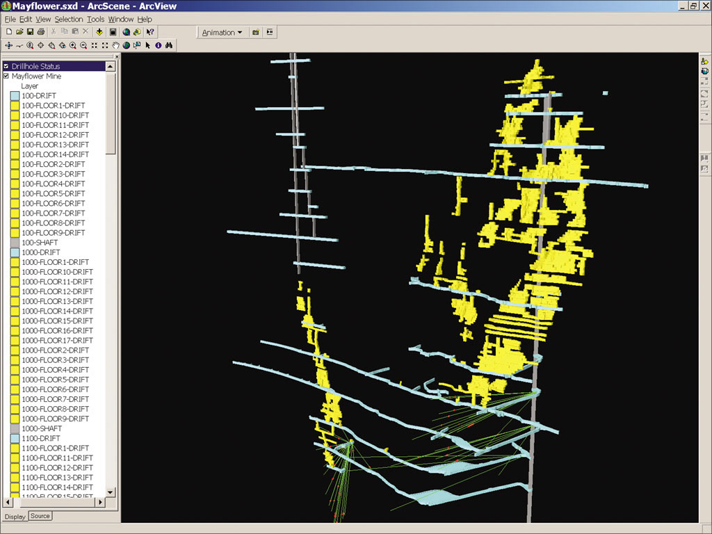
Virtual 3D Model of the Mayflower Mine
Mining Gold in Montana With GIS and Underground Modeling |
|||||
In the movie The Treasure of the Sierra Madre, Humphrey Bogart says, "If there was gold in them mountains, how long would it have been there? Millions and millions of years, wouldn't it? So what's our hurry? A couple of days more or less ain't gonna make any difference." At the time the movie was set, the 1920s, finding gold was often based on a tip, a hunch, or just dumb luck. Today the mining of precious metals is more often done by corporations and funded by investors, not by grizzled prospectors. But patience, such as Bogart's character advises, is as important as ever in making mining profitable. In the mid-1990s, Brimstone Mining, Inc., purchased the historic Mayflower Mine in southwest Montana. The Mayflower Mine had been a top gold producer in the 1930s. The value of gold when Brimstone bought the mine, along with the prospect of applying more advanced mining techniques, provided the stimulus to reopen the mine. Years of previous mining activity had left numerous "stopes," open underground areas where ore had been extracted, and "drifts," horizontal tunnels that led from the access shafts to the ore bodies. In all, mining had been conducted at 20 different horizontal levels reaching 1,900 feet below ground level. Detailed mapping of these excavations over the years reflect the times at which they were conducted. Brimstone had a collection of drafting on linen, old paper maps, and surveys of varying degrees of detail and accuracy. Brimstone needed to bring in experts to help it make sense of the data. In 1998 it hired Esri Business Partner DTM Consulting of Bozeman, Montana, to help it visualize the extent of the historic excavation and help plan future drilling by identifying and quantifying new reserves. DTM is a GIS consulting firm with a strong background in natural resources and earth sciences. DTM's experience in the mining sector and detailed knowledge of the local geology, combined with its extensive GIS and CAD capabilities, made it a perfect choice for completing this task. The firm has clients in the areas of environmental assessment, water resource management, oil and gas, mining, and urban and rural planning. "The Mayflower is a fairly complex mine with a lot of things going on geologically," says David Marshall, co-owner, DTM Consulting. "In order for the exploration to proceed efficiently, we needed a way to visualize everything that has gone on and help the client identify potential new ore reserves, place exploratory drill holes, and target the new reserves." DTM immediately began to use GIS to compile all the data that had been collected over the years into a three-dimensional database. According to Marshall, 10 or 15 years ago the data would have been managed by hand.
"What we did is to take all of the historic data sources and put them in a digital format so we could visualize them within the GIS," says Tony Thatcher, co-owner, DTM Consulting. "The process involved in the analysis and targeting of potential new gold reserves is greatly streamlined by working within the digital environment." Much of the drafting of the old mine working surveys was done with a CAD system. The actual drafting was done with a large-format digitizer using CAD software and constructed in such a way that it could be easily imported into ArcView. Additional digitizing of geology, assay values, and other infrastructure within the mine was done within the GIS. All features were given 3D attributes such as elevation and height. "We created a series of maps of constant elevation representing each drift, stope, and shaft level," says Marshall. "For instance, there might be a map called the 1,400 level, and that's all the information that's at 1,400 feet below ground level. There's a whole series of these stacked levels that, when combined, create a 3D model of the mine workings. Everything was digitized for import into ArcView 3.2 with the ArcView 3D Analyst extension." One of the biggest challenges to DTM was compiling data from multiple sources of unknown reliability. Once exploratory drilling in the mine began, mistakes could prove very costly. "The mined out areas throughout the complex really wiggle around all over the place as they followed the high-grade ore reserves," says Thatcher. "If you're just looking at paper maps, which are drawn at different times at different scales, it's very hard to visualize from that information how the whole mine is actually laid out and what the geologic control is. You want to start a new exploratory drill hole in a direction that hasn't been mined out. If you accidentally hit one of the drifts or stopes, that's a lost drill hole, and there goes about $30,000 down the tubes. If we're off by a degree or two, that might make the difference between success and failure. So we can drill these virtual drill holes in electronic space and really refine how the drill hole needs to be set up in order to hit a prospective target. This process can potentially save tens or even hundreds of thousands of dollars." In addition to helping determine where to mine next, the 3D images and animation capabilities allowed DTM and Brimstone to demonstrate their plans in an easily understood fashion to potential investors. "This type of project is usually not funded internally through the actual mining company, but rather through investment capital," says Marshall. "Being able to visualize what is taking place under the ground makes them a little more comfortable about putting their money down." DTM worked with Brimstone for more than a year on the Mayflower Mine project. Unfortunately, about halfway through the project, the price of gold dropped dramatically. It fell from its 1996 price of more than $400 an ounce to less than $300 an ounce by the end of 1997 and has not fully recovered. Brimstone abandoned its plan to continue exploration and sold its interest in the Mayflower Mine. However, the potential to explore and glean the remaining gold from the mine still exists--when the time is right. According to DTM, with a favorable gold price, a successful exploration project for a mine of this scale could yield between $20 million and $50 million. In the meantime, DTM has been working with advancing GIS technologies and is ready to apply its skills to the Mayflower Mine again, if called on by the mine's new owners. "One of the things we've worked on subsequent to this project has been a series of custom analytical tools that run within the ArcView 3.2 environment--Avenue extensions and scripts--that allow us to analyze the 3D geologic information," says Marshall. "We can even more accurately understand the geological environment in which these gold deposits formed. From that we can extrapolate where we might find more gold reserves. Overall, we've improved our analytical capability for this type of data." "We'd also probably bring this into the new ArcGIS 8.2 environment. The visualization capabilities within ArcGIS 3D Analyst are greatly improved," adds Thatcher. "We can do much better visualizations for potential investors including animated fly-throughs." Although the Mayflower Mine project is on hold, DTM Consulting is far from idle. It continues to consult on other mining projects, but the DTM partners say that one of the most active and growing sectors of its Business is water resource management. The firm has been busy lately helping state regulatory agencies meet EPA mandates associated with the Clean Water Act. For more information on DTM Consulting, Inc., contact David Marshall or Tony Thatcher (tel.: 406-585-5322, e-mail: david@dtmgis.com or tony@dtmgis.com, Web: www.dtmgis.com). |