Winter 2002/2003
Winter 2002/2003 |
|||||||
|
|
|||||||
Germany's State Government Integrates GIS as a Core Technology
Northrine-Westfalia's Department of Agriculture Distributes Geodata to Thousands of Employees |
|||||
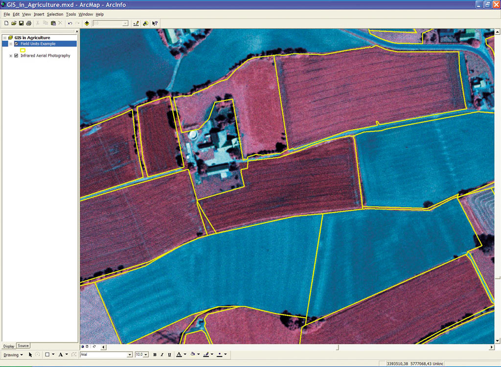
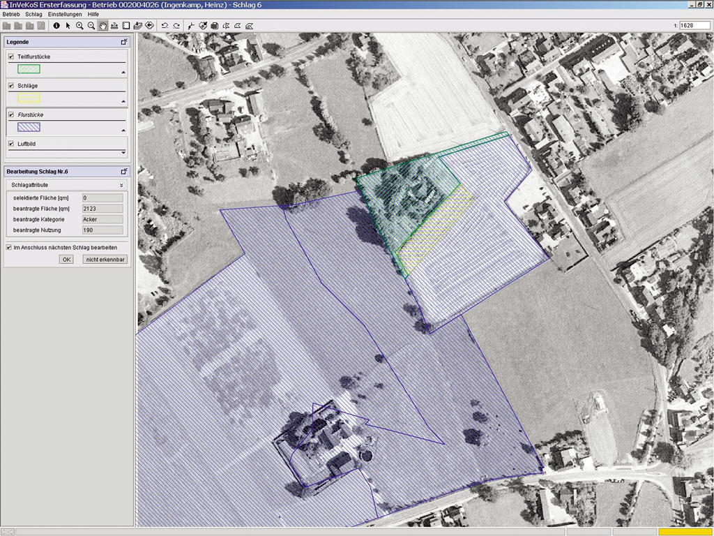
Germany's state of Northrine-Westfalia (NRW) has a large Department of Agriculture with thousands of employees. In 1998, the department realized that it needed a way to distribute its geographic data departmentwide. The department possesses many kinds of basic data such as topographic maps (scales from 1:200,000 to 1:5,000), a digital elevation model (scale 1:5,000, vertical accuracy of 10m, horizontal accuracy of +/-20 cm), and aerial photography (30 cm resolution). It also houses specific data such as environmental protection area boundaries, soil maps, administrative boundaries, and much more. The Institute for Agricultural and Forestal Informatics (afi) of the University of M�nster in NRW analyzed the implementation of GIS for the Department of Agriculture. The department then recognized that GIS was capable of handling the many spatial tasks that it needed accomplished and decided to integrate GIS as a core technology within its already existing information technology (IT) structure in all fields of application. Since then, afi and its partners have formed the Competence Center-GIS for Agriculture and Forestry (CC-GIS). CC-GIS consortium members include afi; con terra GmbH (M�nster), an Esri Business Partner and software vendor; the Institute for Geoinformatics (IfGI) of the University of M�nster; and pro-Plant Company (M�nster), a designer of crop consultancy software. CC-GIS had a mission to establish GIS as a core technology for NRW's agriculture and forestry. The results have been impressive. The core of the integration is a geodataserver, comprising the Oracle relational database management system and ArcSDE 8.2 for storing and maintaining all geospatial data in a central location. ArcIMS 4 is used to distribute all geodata departmentwide to thousands of department employees. Olaf N�lle, project manager and GIS coordinator at afi, says, "At afi, we have finished an agricultural geodata layer for our state called farm site-location coverage. Using GIS, we now have access to information about every farm in Northrine-Westfalia (approximately 60,000 locations). Nearly all agricultural activities are attached to the agricultural parcel, or field unit; therefore, the field unit is integral to the government agriBusiness incorporation of GIS. We have developed a method to partially derive field parcels automatically using official cadastral data and aerial photographs produced by the state's Land Survey and Mapping Agency." N�lle states, "Besides the implementation of a fundamental GIS such as ArcSDE, we are implementing specific GIS applications for studies such as watershed management, erosion protection, agricultural planning, environmental protection, and mobile acquisition of soil samples. We are now migrating from ArcView 3.x to ArcGIS, while incorporating additional tools such as ArcPad." The Bigger PictureIn a 2000 mandate from the European Union (EU), all farmers of member states are required to use GIS when they apply to EU for agricultural funding (see "European Union Mandates GIS for AgriBusiness Aid"). The intent of the mandate is to ease the burden of paperwork and to increase accuracy and analysis through updated technology. To make this possible for all in the agriBusiness industry, GIS Web services are being developed to assist farmers.
The EU regulatory order for GIS has become one of the most important driving forces for the use of GIS within Germany's agricultural domain. To support regulation compliance by its affiliates, EU is providing grants to departments of agriculture and other agencies that will enable them to integrate the GIS technology they need. Because of EU's economic support and legal thrust, for example, several German state agencies already have geodataservers up and operating. As a consequence, departments of agriculture of member states consider the correct application of GIS a necessity for the integrated administration and control system for agricultural funding. Although EU has issued the mandate to its members, it leaves the method of meeting these requirements at the member state level. The state of Northrine-Westfalia is responding with a foresight that not only looks to a GIS that offers EU compliance but also has a vision of the potential of GIS to offer services beyond the scope of the mandate. Moreover, NRW's solution considers not only compliance on a national level but makes it possible for the small Business farmer to successfully meet compliance requirements as well. Looking AheadThe partners of CC-GIS (especially afi, con terra GmbH, and IfGI) and a variety of parties from the private and public sectors are working toward building a spatial data infrastructure for the state of Northrine-Westfalia--GeoDataInfrastructure Initiative NRW (GDI NRW). N�lle describes his vision of this data spatial infrastructure: "At first, agricultural geospatial services could simply be a field unit documentation service accessible via the Internet by every farmer. From this point, we can extend consulting services. It is all about using and refining existing geodata. In this context geodata is no longer seen as simply data but as a product that must be brought to market. Making geodata accessible through geospatial services within a geodata infrastructure gives the product both value and customer appeal. The geodata servers will operate as network nodes within this infrastructure." When all this becomes a reality, NRW and CC-GIS will provide online geospatial services to small farm Businesses that are not accustomed to using GIS. Most owners of small farm operations do not have GIS on their desktops. Through geospatial services, however, these farmers can complete aid applications on the Internet using GIS-enabled Web services. The application will allow the farmer to identify, edit, or create field units based on aerial photographs and cadastral data, thus enabling the farmer to complete the application from the farm office. Once the farmer has sent information to the server, the server application will confirm the correctness of the data. Should this be incongruent with the geodatabase, farm bureau employees will take mobile GIS units into the field to resolve discrepancies. Farmers will also be able to take advantage of the IT support offered by local farm bureau offices where a representative can assist them with filling out the online applications. For more information, contact Olaf N�lle, the Institute for Agricultural and Forestal Informatics of the University of M�nster (tel.: 0251-83-39767, fax: 0251-83-39763, e-mail: nolleo@ifgi.uni-muenster.de). |