Winter 2002/2003
Winter 2002/2003 |
|||||||
|
|
|||||||
Trying to Prevent Extinction With GIS
Saving the Po'ouli--A Critically Endangered Hawaiian Forest Bird |
|||||
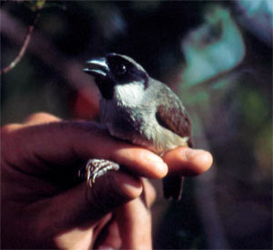
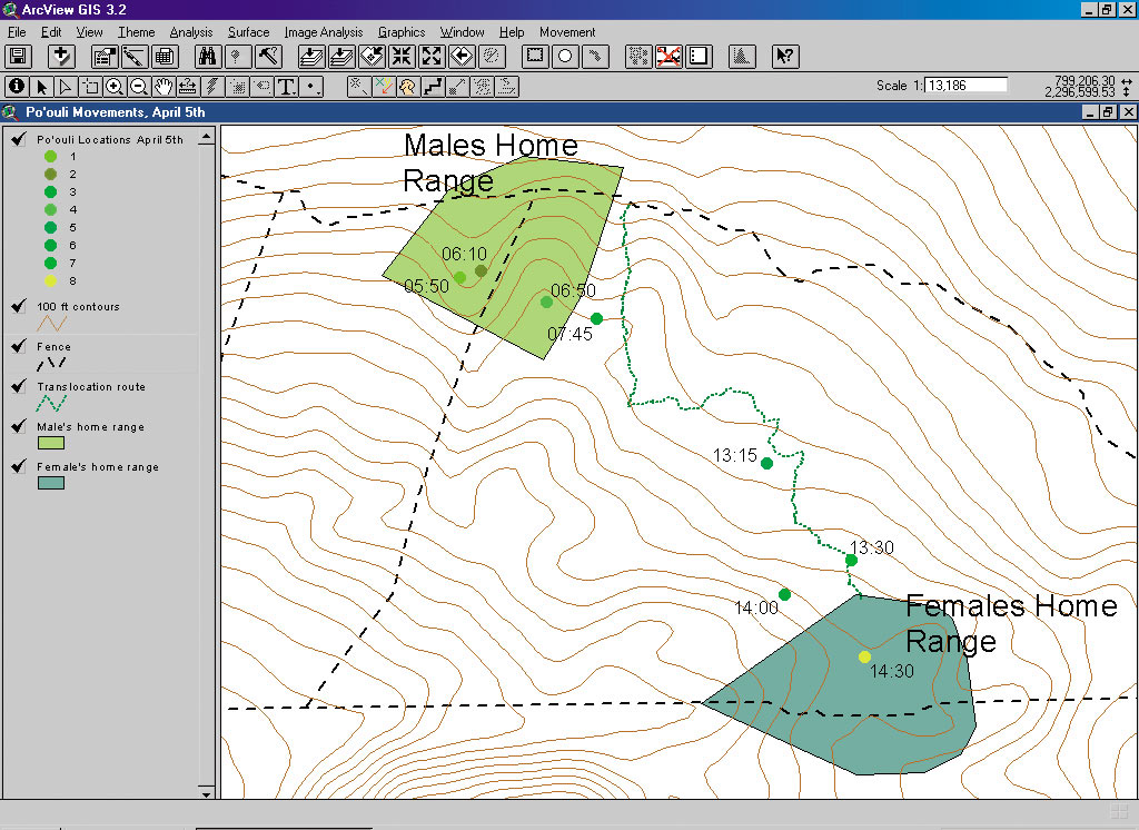
On May 4, 2002, a small group of scientists working for the Maui Forest Bird Recovery Project, Hawaii, caught and translocated one of the world's most endangered birds. This was done in a last ditch effort to save the Po'ouli, a critically endangered Hawaiian forest bird, with a known population of only three individuals. It was a culmination of many years of work by several state and federal agencies, and GIS was an integral part of its success. The Po'ouli, or black-faced honeycreeper, is found in an extremely rugged and remote area of rainforest on the windward slopes of Maui, Hawaii. This area is between 5,000 and 7,000 feet in elevation and averages more than 365 inches of rain per year. At the time of the species discovery in 1973, there were thought to be roughly 140 individuals. Its population has been in a steady decline, and since 1997 only three birds have remained. Each of these birds lives in separate areas of the forest, and close field monitoring has indicated that there is little chance of natural pair formation. By 1999, with no new individuals, and no sign that the three birds would interact and breed, the U.S. Fish and Wildlife Service and the State of Hawaii Division of Natural Resources reached a decision to move one of the two females into the lone male's home range. The task of carrying out this translocation attempt was assigned to the Maui Forest Bird Recovery Project. To accomplish this task it was necessary to catch one of these females using mist nets. Trying to catch an individual bird is always difficult. The solution was to map the birds' home ranges using past field sightings. Marked sightings in the field dating back to 1998 were collected with a Trimble Pro XR GPS unit. Unmarked sightings were approximated in ArcView 3.2 using bearing and distance measurements from fixed locations in the field based on recorded field observations. The scientists then used the Animal Movement Analysis extension to ArcView to identify home ranges for each of the birds. This extension was produced by the United States Geological Survey Alaska Biological Science Center and contains a wide range of functions useful in the analysis of animal movement. The team created home ranges using the kernel analysis function. Field biologists then used this analysis to place nets, which maximized efforts to capture two of the three remaining Po'ouli. Radiotelemetry platforms were constructed months in advance. The team tested its method by radio tracking people within the Po'ouli home ranges. The plan was to first capture the male Po'ouli and attach a radio transmitter to his back. Using radiotelemetry and Location of a Signal (LOAS) software, his movements throughout each day could be monitored in the field. LOAS uses the coordinates of tracking location and bearing data from that location to angulate the position of a radio transmitter. It allows the input of multiple bearings in spreadsheet form and the export of locational data as ArcView shapefiles. This information would be used to locate the male in the field once the female was captured and brought to the male's home range. The female would then have a radio transmitter attached to her and would be released near the location of the male. It was hoped that if the two Po'ouli came into contact, the female might stay in the male's territory or the male would follow the female back to her home range.
The team's effort first focused on catching the male for transmitter attachment. Although the male was sighted frequently, he still had not been caught after the team had spent 30 days in the field. The team then decided to focus on catching the female. This was done to complete the translocation before the end of the suspected breeding season. Since the male's daily movements could not be traced by radiotelemetry, the release site of the female would have to be determined by using maps created in ArcView with the Animal Movement Analyst extension if the male could not be located visually. The team created maps using the kernel analysis function with the most recent sightings of the male Po'ouli. Further fieldwork was scheduled, and the team relocated to the female's home range. Again, the team used home range maps created from the female's resight history to help place mist nets in the female's territory. The team was concerned about the female's well-being because she had not been seen for more than eight months. However, luck was on their side; after 12 days, the female was caught. After taking a few quick measurements, the team placed her in a transport container and hiked 2.5 kilometers to the male's home range. After a one hour and 15-minute hike, the team fitted the bird with a .8 gram radio transmitter and placed her in a holding cage where she could be monitored prior to release. After the team rechecked the transmitter signal and receiver frequencies, they carried the female into the male's home range. Despite focused effort, the male could not be found. So the team decided to release the female based on kernel analysis of dusk sightings of the bird during the previous three weeks. Upon release, the female was radio tracked after sunset to determine whether or not she roosted in the male's territory overnight. Previous translocation and release work with other species indicated that there was a high probability that she would immediately fly back to her home range. The following morning radio tracking began before dawn. The female's signal was still being received in the male's home range, but shortly after sunrise she began to move. Telemetry results show that the female stayed in the male's home range until approximately 10:00 a.m. Throughout the rest of the day, however, radio tracking confirmed that she was heading directly back to her own territory. The radio tracking team managed to track her progress and was able to triangulate her position several times during her return. Within 24 hours of her capture, the female Po'ouli was back in her original home range, covering a distance of more than 1.7 kilometers and an elevation gain of greater than 1,000 feet. There was no indication that the two birds ever came into contact with each other. Although the female's return was obviously disappointing, there was still considerable work to be done. Radio tracking continued for the next nine days until the transmitter battery expired. The data collected was continuous and on a much shorter temporal scale than other data collected previously for this species. It contributes greatly, however, to the knowledge of this species and will play an important role in future work. Since no breeding pair was formed, a new strategy is being formed to save this species. It seems likely that the next step for this species will be to try and breed them in captivity. If so, then GIS will also contribute to this next phase of the recovery effort. Information gathered during the translocation will be used to recapture these individuals. For more information, contact Bill Sparklin, Maui Forest Bird Recovery Project (e-mail: poouli@maui.net, Web: www.mauiforestbird.org). |