Winter 2003/2004
Winter 2003/2004 |
|||||||
|
|
|||||||
GIS Helps Response to Southern California Fires |
|||||||||||||
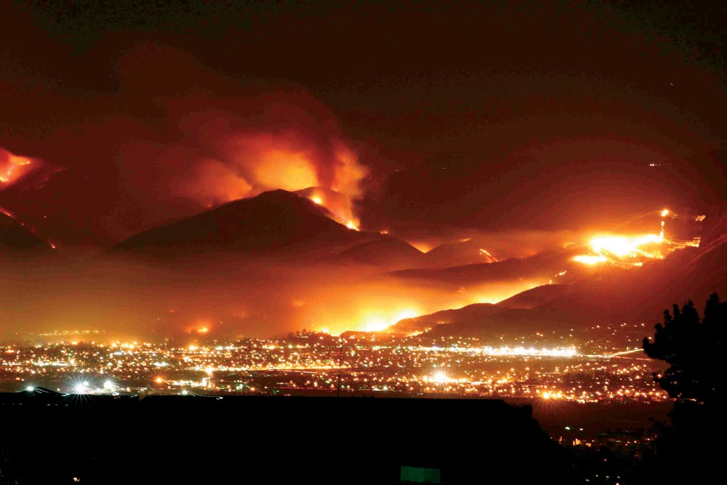
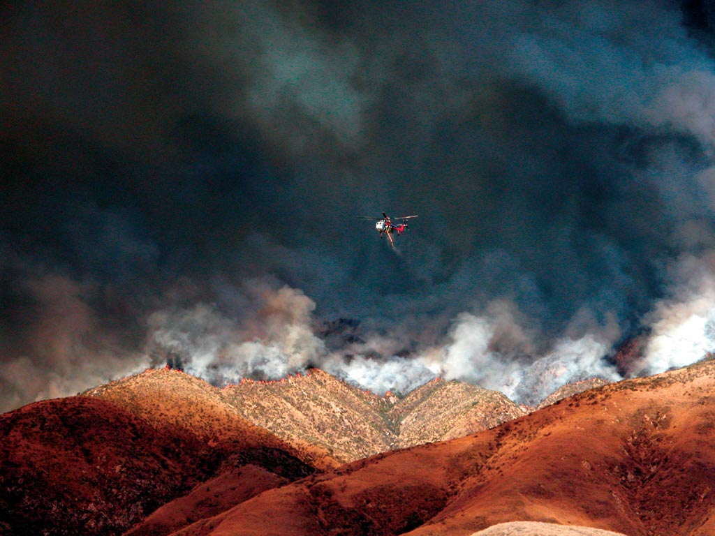
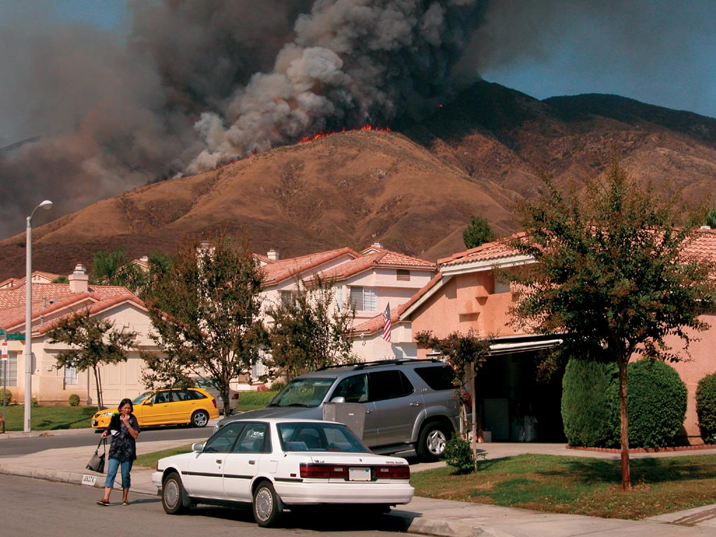
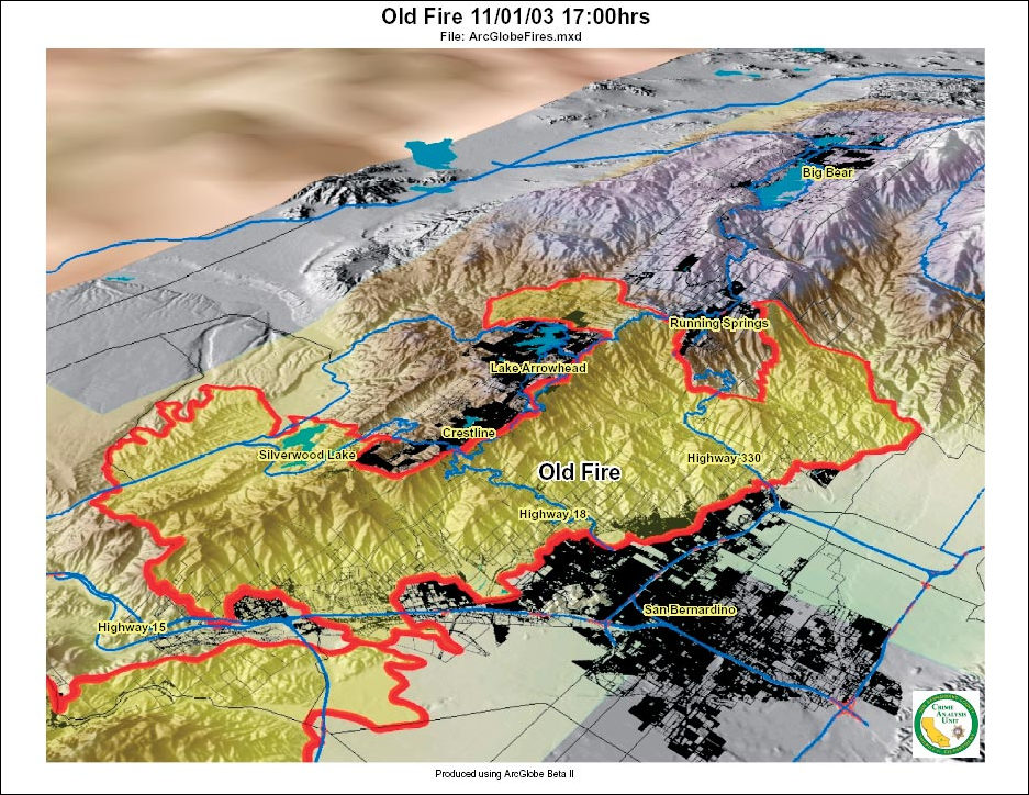
With fires raging all over Southern California—in San Diego, San Bernardino, Los Angeles, Ventura, and Riverside Counties—scorching hundreds of thousands of acres, displacing tens of thousands of people, and destroying thousands of homes, emergency responders worked with all their might to put out the fires with every possible human resource and tool available—and computer mapping played a key role. Emergency response GIS applications included 3D mapping of fire areas and communities, identification of critical facilities, allocation of resources and equipment, incident perimeter mapping, daily strategy and assessment meetings, and creation of mitigation plans. Emergency responders also used GIS to analyze vegetation, slope, and other landscape features to help understand potential and actual fire behavior. Public information professionals leveraged GIS to answer questions about fire locations, road closures, and damaged or undamaged property locations. Law enforcement used GIS to plan evacuations, monitor events, and investigate possible criminal activities. Government officials drew on Web GIS and other GIS services to understand wildfire damage and communicate information to both constituents and other government representatives and agencies. In addition, maps and GIS demonstrations were central components at separate meetings to brief then Governor-elect Arnold Schwarzenegger, then Governor Gray Davis, and President George W. Bush (see sidebar). Three-Dimensional Analysis and Visual Fly-ThroughEmergency responders, operations commanders, government officials, and others used GIS software for daily briefings and strategy sessions. Some of these sessions included the use of ArcGIS 3D Analyst 9 software's ArcGlobe application to provide 3D mapping of fire areas and communities. Officials viewed and analyzed 3D GIS data while navigating landscapes in a virtual environment. The technology helped firefighters and fire managers become quickly oriented to factors such as vegetation types, slope characteristics, and values at risk. In addition, ArcGlobe was used to help organize evacuations, locate fire lines, model fire progression, and help predict fire behavior. Fire, law enforcement, local, state, and federal officials and others worked with a common spatial database and visualization tool for decision making and collaboration.
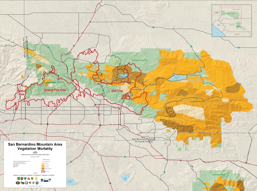
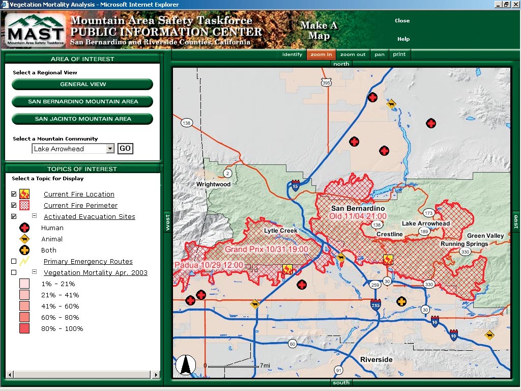
The use of three-dimensional analysis and visual fly-through provided several benefits. For instance, the overview and orientation that ArcGlobe provided was only otherwise available by flying in a helicopter to view the fire conditions. ArcGlobe also provided a safe, cost-effective, and efficient method to look at many different data sets integrated and displayed based on user specifications. Esri GIS technicians assisted incident commanders as they performed overall incident command briefings, which were held twice a day when shifts changed. The GIS analysis presented during the briefings was based on emergency responder requests and the specific, daily needs at the Incident Command Post. Data input into ArcGIS included high-resolution imagery, vegetation data, fire perimeter and fire progression data, digital elevation models, land parcel and structure data, and asset location data. Web Sites Provided Live MapsWeb sites provided live maps and information for recent major fires as well as fire prevention and planning. The first of two newly launched GIS-enabled Web sites provided (and continues to provide) current Southern California fire news and emergency response information that was of immediate interest to the public. The second site provided information on fire prevention strategies, programs, and resources that is of more long-term interest. Both of these related Web sites were developed and are maintained by Esri and its partner agencies at the direction of several affected government agencies. These sites make extensive use of GIS maps and live mapping technology to keep the public informed. Both Web sites are posted on the CalMAST Web site (www.calmast.org). "The Web is a powerful tool for putting out information quickly and easily to those who need it," says Russ Johnson, public safety solutions manager, Esri. "During the fires, these Web sites gave agencies and private citizens critical information such as fire perimeters, vegetation conditions, safe evacuation routes, and fire safe measures that the public can employ." The first Web site—the Mountain Area Safety Taskforce (MAST) Public Information Center Web site (www.calmast.org/mast/public/default.htm)—contains information about fire hazard conditions and fire prevention programs in the San Bernardino–San Jacinto Mountain area of San Bernardino and Riverside Counties. This Web site was launched in September 2003 for the San Bernardino and Riverside County MAST organizations in response to drought and bark beetle related fire hazard conditions (see sidebar). This Web site provided the initial foundation for near real-time updates of the fire perimeters of the Grand Prix and Old Fires (named after roads near which the fires were first spotted). Work on the Web site has been accomplished through a group of concerned private organizations and public agencies assisted by Esri. General information pertaining to the hazardous conditions, fire prevention projects, volunteer opportunities, and emergency preparedness are accessible via this Web site. Press releases, maps and photos, fire prevention guidance, tree removal guidance and assistance information, a calendar of events, and an interactive Make A Map function and geodatabase, that together enable users to make maps for a specific area of interest, can also be accessed.
The second Web site—the San Bernardino Joint Information Center Web site was developed by Esri working with several partner agencies including the American Red Cross, California Department of Forestry and Fire Prevention, California Highway Patrol, California Office of Emergency Services, Caltrans, City of Rancho Cucamonga, City of San Bernardino, Riverside County Transportation Department, San Bernardino County, San Bernardino Fire Department, U.S. Bureau of Land Management, U.S. Federal Emergency Management Agency, U.S. Forest Service, and U.S. Geological Survey. The Web site was created as the official source for information about active fires in the San Bernardino National Forest. The site primarily focused on the Grand Prix and Old Fires but also provided information on the active fires in Los Angeles, San Diego, and Ventura Counties. The latest closures and evacuations and fire perimeter and online maps, as well as printable maps and satellite images, were provided at the Web site. In addition, information was available on Red Cross shelters, financial assistance, insurance-related information from the state of California, flight restrictions, school closures, public safety, and much more. Links to Related Web SitesAlso included in the two Web sites is GeoMAC Wildland Fire Support for fire managers and the MODIS (moderate resolution imaging spectoradiometer) Active Fire Mapping Program (activefiremaps.fs.fed.us) for large incident fire maps. The GeoMAC Web site (www.geomac.gov) alone received nearly 1.25 million hits from October 26 through October 31, 2003. GeoMAC is a real-time application that provides geospatial information on the status, location, and proximity of wildfires to life, property, and infrastructure. This visual representation of active fires gives managers a better idea of which fires pose the greatest risk and require immediate fire fighting resources. GeoMAC is supported by a multiagency group with members from the Bureau of Indian Affairs, Bureau of Land Management, National Interagency Fire Center, National Oceanic and Atmospheric Administration, National Park Service, Office of Wildland Fire Coordination, U.S. Department of Agriculture, U.S. Department of the Interior, U.S. Fish and Wildlife Service, U.S. Forest Service, and the U.S. Geological Survey. Private corporations, including Esri, ERDAS–Leica, IBM, and Sun Microsystems, provide mapping software applications, computer hardware, and technical expertise to the GeoMAC effort. Links were also available at the two Web sites to geodata.gov and several other sites to provide state maps and satellite imagery. GIS Helps San Bernardino County SheriffThe San Bernardino County Sheriff's Department and other local police agencies used GIS software for a host of evacuation activities and responses to the Grand Prix and Old Fires. GIS-generated maps were used to help carry out evacuations, monitor traffic, display fire perimeters, assess damage, patrol evacuated areas, plan community reentry, and much more. Esri supplied software, hardware, including plotters, and GIS professionals to assist the sheriff's GIS staff on-site.
The Sheriff's Department took the lead on the law enforcement GIS projects, acting as the coordinating agency for all other police agencies. Within an hour after the Old Fire started, the Sheriff's Department and Esri were generating the first maps for the fire showing the location and the detailed road network for the mountain communities in immediate danger. Such a quick response was possible through the collaborative MAST effort. The Sheriff's Department shared GIS maps and data with fire and other agencies, including the San Bernardino County Emergency Center, California Highway Patrol, and local police agencies. Maps are also being used as part of the arson investigation. Esri personnel worked on-site to support the Sheriff's Department by plotting maps of various areas affected by the fires. Esri's Database Services Department provided daily fire perimeter shapefiles. Many of the map requests were for specific close-ups of the burned inhabited areas showing streets and parcels. These maps helped provide the Sheriff's Department a continuously updated, accurate understanding of the emergency. Big Bear Fire MitigationThe incident management team used GIS to create digital maps and contingency plans for the mountain community of Big Bear in the event that the Old Fire scorched its way past firefighter perimeters. Esri provided GIS technicians from its Professional Services Group and software for this effort.
An Incident Command Post was established at the convention center in Big Bear. It was tasked with addressing the possibility that the Old Fire might spread past Lake Arrowhead and toward Big Bear Valley, a heavily populated resort community nestled in the San Bernardino National Forest. The Operations Group used GIS to create fire progression maps, topographical maps, property maps, and more. Information about the locations of utility infrastructure—such as power lines, towers, and aboveground gas valves—was also incorporated because local utility companies provided CAD data in a format compatible with GIS. These maps were used for a number of decision-support purposes. For instance, GIS was used in the field to capture the locations of fire breaks. At the Incident Command Post, the data was digitally updated in a central GIS database. This allowed the GIS unit to quickly disseminate up-to-date information to the primary Old Fire Incident Command Post, helping track the progress of field units and identify plans for the construction of contingency fire breaks to prevent the fire from entering Big Bear Valley. "A lot of the information was dynamic, with constant data updates and historical data viewed for various purposes," says Ray Carnes, Esri. A second group also using the services of the GIS unit was the Information Group, responsible for handling public and media inquiries. Digital and paper fire maps showing fire perimeter, fire progression, fire break, property data, and more helped inform affected communities about what was occurring and helped support the media in their reporting efforts. A third group consisting of Bureau of Land Management staff used digital 3D maps to make a presentation on Wednesday, November 5, to senior government officials on the latest status of the fire, its containment, and final wildfire plans. In the aftermath of the contingency planning and with the fire 100 percent contained, the new Big Bear maps were brought back to the primary Incident Command Post for final fire response efforts, reentry operations, and rehabitation work. Recovery Work
"The Southern California wildfires impacted millions of people," says Johnson, "and we at Esri worked closely with incident management teams, emergency responders, and others to help in any way we could. We assisted government agencies with many different types of GIS analysis and mapping services. These efforts helped assess risks, map fire perimeters, allocate resources, evacuate residents, protect property, create contingency plans, and more. With events now over, we're doing what we can to help the recovery efforts." Esri staff are working on a number of recovery fronts. Staff are currently working with the U.S. Forest Service and San Bernardino County flood control officials to model possible winter mud slides that could result from heavy rains. "We're working to do what we can to speed up the recovery for those affected by wildfires," says Johnson. "We currently work with a number of agencies, and we will continue to do so for as long as necessary." Esri gratefully acknowledges data provided by DigitalGlobe, Inc. For more information, contact Russ Johnson, Esri public safety solutions manager (tel.: 909-793-2853, ext. 1-1836; e-mail: russ_johnson@esri.com). |