Winter 2003/2004
Winter 2003/2004 |
|||||||
|
|
|||||||
Supporting Its Watershed Protection Program
New York City Department of Environmental Protection Uses GIS to Locate Impervious Surfaces |
|||||
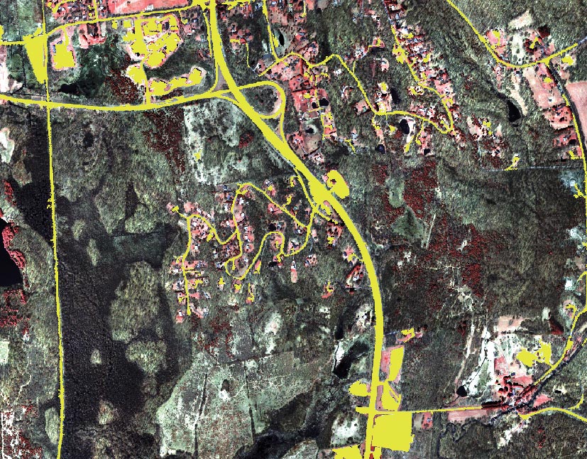
The New York City (NYC) Water Supply System consists of approximately 2,000 square miles within the Catskill, Delaware, and Croton Watersheds in upstate New York. The water supply system, providing drinking water to almost nine million people in the NYC metropolitan and surrounding areas, consists of 19 drinking water reservoirs with a total storage capacity of 580 billion gallons and a series of connecting aqueducts. This is the largest gravity-fed and unfiltered water supply system in the world. Maintaining the high quality of fresh water that meets or exceeds all state and federal drinking water standards is of the utmost importance. The challenges of accurately modeling water quality, monitoring population and development trends, and managing land use practices for the watersheds are formidable. Effective use of GIS and remote sensing technologies is a key ingredient in the success of the watershed protection program administered by the New York City Department of Environmental Protection (NYC DEP). To meet these challenges, NYC DEP has embarked on a major information systems architecture initiative that embraces GIS as the core enabling technology. Esri Business Partner PAR Government Systems Corporation of Rome, New York, has a long history of performing image classification and feature extraction using various commercially available software packages as well as custom in-house software. PAR, in cooperation with the New York State Department of Environmental Conservation, supports NYC DEP by collecting remotely sensed imagery, developing imagery-derived products, building a geodatabase, and designing and developing water quality modeling software tools. Impervious Surface Extraction ProcessOne focus area is the development of land use/land cover products based on automated remote sensing techniques, which includes the extraction of impervious surface features. Impervious surfaces are ground features (e.g., artificial structures such as roads, roofs, tennis courts, parking lots) that do not absorb water and that adversely impact water runoff factors. Locating and quantifying impervious surfaces in a watershed are critical to estimating nonpoint source pollution loading because of runoff, a key component for maintaining clean drinking water. Research indicates there is an imperviousness threshold beyond which no combination of best management practices can mitigate the additional pollutant load resulting from excessive development. The impervious surface identification process was implemented to meet NYC DEP needs for watershed protection and provide a consistent, repeatable methodology for future analyses in support of ongoing monitoring of land use trends and impact to water quality. Terry Spies, GIS coordinator for Watershed Lands and Community Planning in the Bureau of Water Supply at NYC DEP, says, "This data will be useful to NYC DEP for mapping refined land use classes when used with other land cover data, quantifying the level of development in the NYC watersheds, and evaluating the water quality impacts of that development." Application of this methodology over time tracks the change in impervious cover within the New York City watersheds. The resulting impervious surface layer and detected changes integrate with a set of modeling support tools that provide a mechanism to evaluate the impact on the quality of drinking water supplies.
For this study, Esri Business Partner Visual Learning Systems' Feature Analyst extension for ArcGIS was selected primarily because of its powerful feature extraction capabilities but also because it is fully integrated with the ArcGIS Desktop products (ArcView, ArcInfo, and ArcEditor). ArcInfo is PAR's preferred GIS software package for spatial analysis, custom spatial analysis tool development, and spatial data management architecture development. Because Feature Analyst is an extension to ArcInfo and ArcView, the imagery is easily accessed and viewed and the impervious sample sets are quickly created using the interactive tools, allowing the entire extraction to be completed within the ArcGIS Desktop products. The process reduces the need to constantly switch between software packages and eliminates the concern over file compatibility. Impervious surfaces were extracted for the Croton Watershed (approximately 400 square miles) using digital aerial imagery at 0.3-meter ground resolution. The imagery source, collected during the fall of 2001 (minimal vegetative cover or leaf-off conditions), was delivered to PAR radiometrically balanced and orthorectified. PAR mosaicked the three-band color-infrared orthoimagery for data sets that are radiometrically consistent across daily collections. The resulting mosaics were the basis for the impervious feature identification performed using Feature Analyst and ArcGIS. Shape Versus CompositionThe difficulty with creating a standardized radiometric signature for impervious surfaces is because of the large variety of artificial materials used to create these surfaces. Materials include concrete, asphalt, wood, rubber, metals, and plastics. Some of these materials have radiometric signatures that mimic naturally occurring substances from which they are made. Thus, the shape of the surface can be just as important as the composition. It is rare, in nature, to find structures with precise 90-degree corners; this is typical for artificial structures. It is also rare for natural boundaries to be straight edges; however, artificial features often are designed with straight lines. The impervious feature extraction was performed with this in mind. Using a process that considers only the radiometric signature would give up a large amount of information when searching for man-made objects in a natural landscape. A combination of radiometric and spatial properties improves the classification significantly. Thus, data created for impervious surfaces should take both the radiometry and the geometry into consideration. The first step in any Feature Analyst extraction is to specify samples of the desired features. The software uses these samples to automatically extract all similar regions by "learning" the samples' spectral and neighborhood characteristics. For optimum performance the selected features should represent the generalized morphology of the feature class. Areas selected for the NYC drinking watersheds included double lane roadways with and without the double yellow dividing line, highways, driveways, and houses with a variety of roof configurations and materials. Through repeated application of the Feature Analyst software, the extraction criteria are iteratively refined, thus improving results. Combining and separating classes at intermediate stages of the operation allow complex class definitions that build upon previous class definitions. This is especially useful for the extraction of features such as roads where the shape of the roads is consistent across the scene, but the image radiometry varies because of shadows, reflections, or different pavement materials. A key component of the impervious surface feature extraction is the ability to conduct contextual classification via input templates defined by the user. Termed kernels, these templates allow the software to match the shapes of objects and recognize objects in their proper context. For instance, asphalt roofs and roads have similar radiometry but vary significantly in shape and context. The template selected is a primary determinant of the feature extraction's success. This is one of the timesaving benefits of machine learning. Once the kernel and the inputs are selected, the analyst needs only to evaluate each of the intermediate products and refine the learning process. Results from the impervious feature extraction exceeded the expectations of NYC DEP. The accuracy assessment for the entire Croton Watershed region showed an overall accuracy of 97.5 percent. Research has shown that impervious surface studies to date report accuracies as high as 85–90 percent for the overall classification in a watershed. These studies were for impervious or urban classes within a comprehensive land cover classification. The feature extraction methodology attains higher accuracies because the process concentrates on finding only the impervious surfaces rather than on a general classification of the entire image. The resultant impervious GIS data set(s) will allow NYC DEP to better quantify impervious surfaces and include impervious data in its spatial analyses and water quality modeling. For more information, contact George Washburn (e-mail: george_washburn@partech.com), Jennifer Barber (e-mail: jennifer_barber@partech.com), or Kevin Opitz (e-mail: kopitz@vls-inc.com). Some statements in this article were based on research by Terrence E. Slonecker, David B. Jennings, and Donald Garofalo and published in "Remote Sensing of Impervious Surfaces: A Review," Remote Sensing Reviews, Vol. 20, pp. 227-255, 2001. |