Winter 2003/2004
Winter 2003/2004 |
|||||||
|
|
|||||||
The State of Israel Manages Its Seaports and Railways With Enterprise GIS |
|||
|
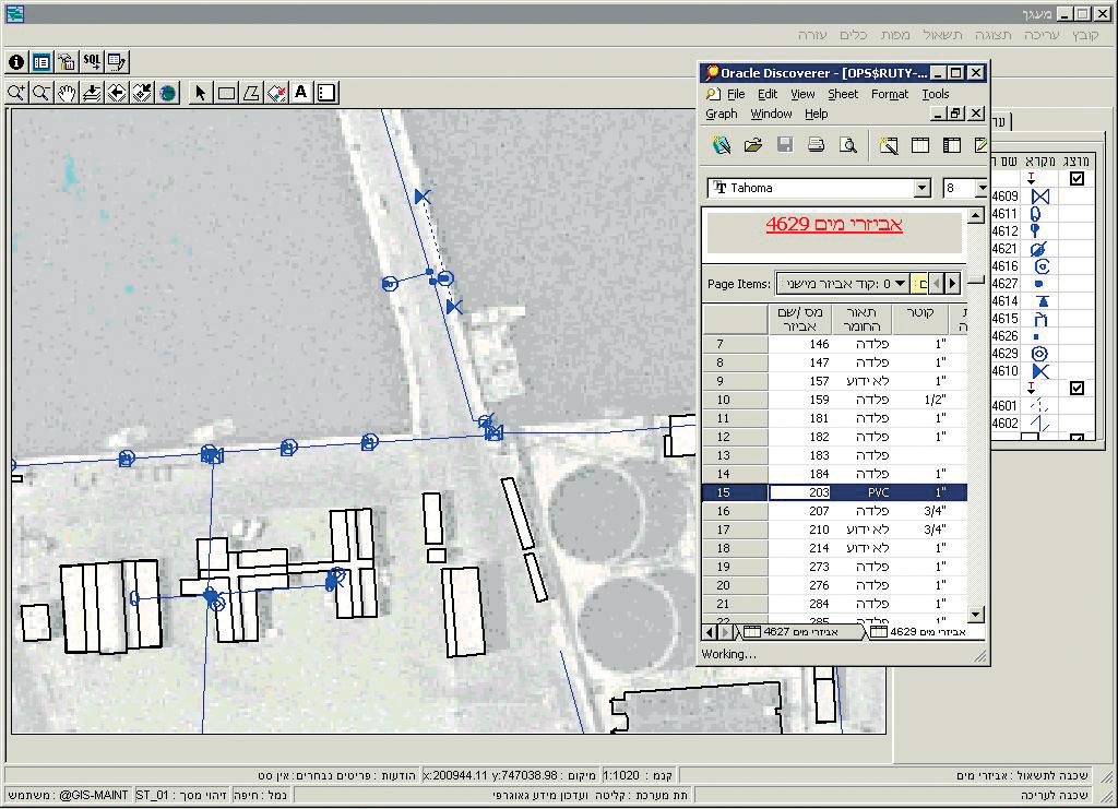
The State of Israel operates three commercial seaports and a railway operating along 991 km of line. It is the responsibility of the Ports and Railways Authority (PRA) to develop, operate, maintain, and manage these operations. PRA is headed by a government-appointed board, comprising 17 public and civil service members. There are two main challenges facing PRA. One is to maintain its services with the cost and quality at levels to meet the existing demand. The other is to plan for and develop new projects to satisfy future requirements of the economy in passenger and cargo transportation.
In 1999, PRA began one of the largest GIS projects in Israel. With a multimillion dollar budget, the goal of the project was to provide a complex GIS system, which would be the cornerstone of many PRA activities. This is the largest budget for a single GIS project in the civilian sector of Israel. This budget covers three components: software, software development and support, and outsourcing. Ruth Schlichter, a PRA project manager, states, "We see GIS as one of the cornerstones of information management in our organization." Rather than managing and maintaining the software, geographic data, and human resources in-house, PRA chose to outsource this work. Presently the Tel Aviv, Israel-based company Geoda Ltd. provides GIS services to PRA including maintaining, integrating, and updating data in the GIS database; providing software updates and upgrades; and providing software support. The enterprise GIS system Geoda developed with PRA has the following main components: assets, facility, and document management; alphanumeric queries; integrated data reporting; integration of CAD and GIS data; and a multiuser environment. Assets management involves PRA's buildings, contracts, operational areas, etc. It also includes legacy assets, whereby GIS provides the ability to visualize data from legacy systems and contribute important spatial referencing to legacy assets data. PRA and Geoda examined the various options, then chose to build the system using Oracle, ArcGIS Desktop (ArcView and ArcInfo), ArcSDE, and MapObjects. The facilities managed include water, sewage, electricity, communications, and drainage. Using GIS has given PRA the ability to act quickly in the case of a failure within the facilities. "This GIS system is involved on a 24/7 basis in most of our activities including planning, assets and facilities management, operation management, and others," Schlichter says. GIS has been designed to provide a Failure Card, which is a map of the failure location and any descriptive text or documents regarding the failure. The Failure Card provides the repairing crew with information about the failure along with possible dangers. Another component was an enhanced GIS–CAD converter (and vice versa) since some facilities planning is still performed using a CAD system. For this conversion the rules are flexible and may be adapted to different information schemas in AutoCAD drawings (layers, blocks, attributes, etc.). The system has been designed so that any document from the system database can be attached to geographic features; therefore, the document becomes an integrated part of the feature information data set. Documents can also be retrieved for viewing as part of a general information retrieving process. These documents may include images, word processing files, CAD drawings, etc. The system contains a special Query Builder component, which helps to build and run SQL queries through a simple and intuitive interface. The query result can be displayed using either an alphanumeric result or a geographic one using ArcGIS Desktop. Frequently used queries can be stored. The system was also designed from the ground up to work within a multiuser environment, utilizing one central application server. The system includes security to manage users and data by establishing the need for permissions either on objects (geographic layers) or operations. Also, within this enterprise GIS, an enterprise data reporting system using Oracle was combined using ArcSDE to enhance the services to the end user. One of the challenges of the project was to provide PRA with software and a complete geographic database simultaneously. The software included the previously mentioned packages along with some enhanced interfacing to provide PRA with the main components for the enterprise GIS. The geographic database was created from the legacy orthophotography, CAD drawings, paper maps, and PRA alphanumeric data. Most of the CAD drawings and scanned maps (once digitized) were converted to shapefiles. Since the system was based on ArcSDE, it had the ability to store GIS data in a relational database (Oracle). The database consists of layers of geographic information, and every layer represents certain types of objects (water pipes, buildings, electric lines, etc.). Using ArcSDE allows for a spatially enabled database table, and since geographic layers are database tables, any feature of the database can be used as a business table (constraints, triggers, PL/SQL programming, etc.). There was further data integration, along with a quality control process, providing PRA with a stable database from which to run its operations. For more information, contact Michael Ginzburg, software development manager, Geoda Ltd. (e-mail: michael@geo-da.co.il, tel.: 972-58-265526). |