Winter 2003/2004
Winter 2003/2004 |
|||||||
|
|
|||||||
Texas Department of Transportation Uses GIS for Official Travel Map |
|||||
|
The mission of the Texas Department of Transportation (TxDOT) is to provide safe, effective, and efficient movement of people and goods. Established in 1917 as the Texas Highway Department, TxDOT administers state and federal funds for highway construction, maintenance, navigation, and safety. The Travel Division of TxDOT supports the TxDOT mission by inspiring safe and pleasurable travel to and within Texas. The Texas Official Travel Map is one of several publications produced by the Travel Division for this purpose.
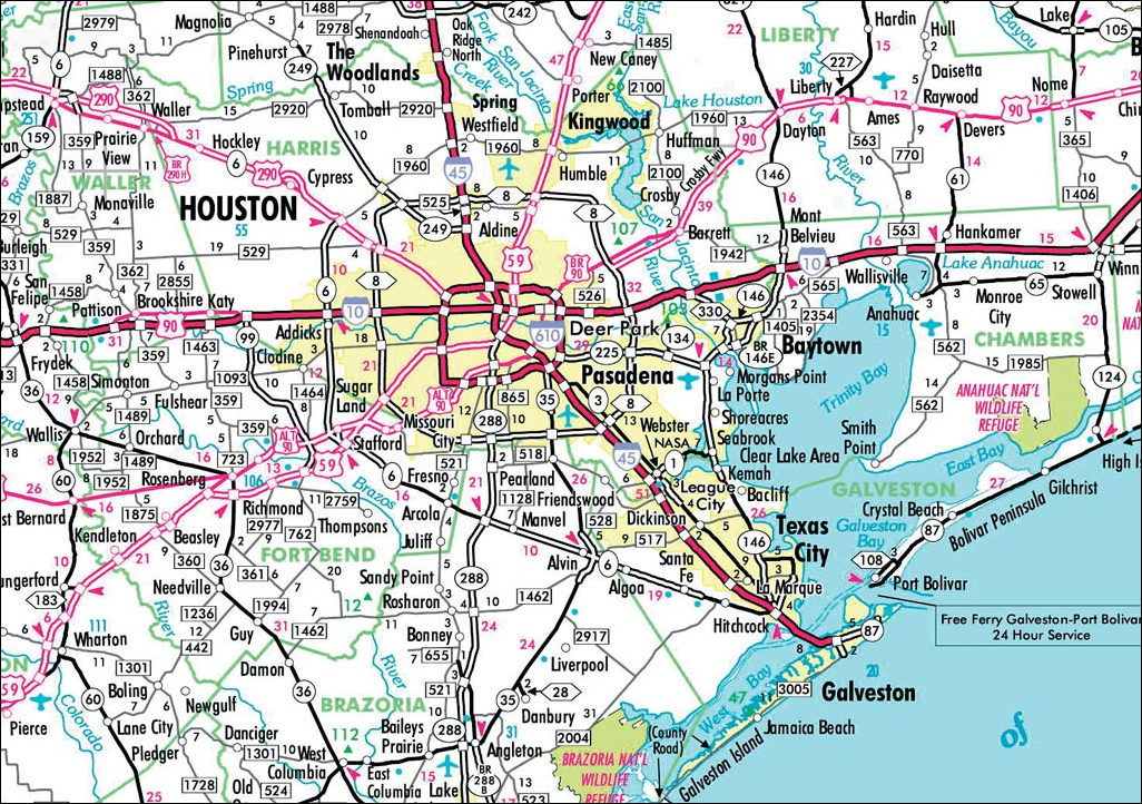
The map is a standard, folded road map with the state of Texas on one side at a scale of approximately 1:1,500,000 and insets of major cities on the other side at various larger scales. When folded, the map has front and back covers that include illustrations and text. The map shows county lines, cities, roads, rivers, lakes, and other feature data and indexes to features such as state parks, national wildlife refuges, forests, and grasslands. Other items on the map include a chart showing the mileage between cities in Texas, various pieces of travel information, and a legend. When the time came to update the map, the Travel Division began by updating its mapmaking processes using GIS technology from Esri, which was being used in TxDOT. "All previous editions of the travel map were made using traditional cartographic methods, scribe coat, and stick-up text," explains Dan Mullis, the Travel Division's travel map editor. "The processes involved in updating the map had become increasingly more difficult and more expensive. Given the impending growth in TxDOT's GIS technology, it became clear that producing the map with GIS technology was our best option. It was important that we employ this new technology to modernize the map." Developing Automated Mapping ProcessesIn February 2001, following the issuance of a request for proposal, TxDOT awarded Esri Professional Services a contract to begin developing database driven processes to create the next version of the Texas Official Travel Map, document these new processes, and train TxDOT staff on the developed procedures. In redesigning these processes, TxDOT and Esri developed procedures and technology for producing the map in an all digital environment. "The key to the development of the automated mapping procedures was the implementation of a single centralized database," explains Mullis. "With ArcGIS and database-driven technology, the geodatabase used by this project for the production of typical road maps contains all the geographic feature data that TxDOT once kept in a variety of digital formats."
The first step in updating this process was to build a prototype of one portion of the map. TxDOT focused this prototype effort on the city of Houston. The prototype included the creation of a detailed map of the Houston area and the prototype layout for the map product. The prototype focused on bringing data from many different sources into a single geodatabase with a common data dictionary. These sources included coverages and shapefiles, and the vast majority came from design files maintained by the Transportation Planning and Programming Division within TxDOT. Next, symbology for the map was created and assigned to features. ArcGIS Desktop was used to label the features and convert them to annotation. Once all the data was combined into a single ArcSDE geodatabase, a database designed to support cartographic production, Esri used ArcGIS Desktop for cartographic finishing and Adobe Illustrator for map layout. After cartographic finishing and quality control, TxDOT worked with its prepress and printing vendors to produce printer proofs of the map. Based on the success of the prototype area, TxDOT moved forward with its plans to develop the complete Texas Official Travel Map including 26 city insets. To begin this phase, TxDOT completed implementation of an agencywide enterprise geodatabase that is maintained by its Information Systems Division and Geographic Information Systems and Database Administration sections. TxDOT staff migrated statewide data from numerous state and federal sources, many of which were used during prototyping. Esri took this migrated data and developed an update scenario with custom software tools that took data from the GIS enterprise geodatabase and pulled the changed features into GIS Data ReViewer; the Travel Division could then update the travel map geodatabase. "Using the commercial off-the-shelf-based GIS Data ReViewer for managing updated features," says Mullis, "eliminated the need for more expensive custom application development." The process developed during this digitization project gives TxDOT more powerful tools to create other map-based products quickly and accurately for the traveling public. "The process we created for the Texas Official Travel Map offers several key advantages to TxDOT," says Holly Ying, Esri project manager. "It automates and improves the map production process by using a seamless enterprise geodatabase and ArcSDE solution." Adds David Watkins, Esri Professional Services Division, "The process allows the Travel Division to easily create map products for additional travel publications or to suit other business objectives. It also streamlines the update process of changes from the TxDOT enterprise geodatabase to the travel map geodatabase." For more information, contact Dan Mullis, Texas DOT Travel Division (tel.: 512-486-5875, e-mail: dmullis@dot.state.tx.us), or David Watkins, Esri cartographic technical manager (tel.: 909-793-2853, ext. 1-1165; e-mail: dwatkins@esri.com). |
 Whether taking a wildflower tour through the hill country in central Texas, escaping to one of the many state parks in the northeast part of the state, or driving the 899 miles of U.S. Highway 83 that extends from the Oklahoma state line in the panhandle to the Mexico border at Brownsville, visitors to the state of Texas rely on the Texas Official Travel Map to guide them through this vast landscape.