 |
Four Mountains, Four Esri T-Shirts!
Wayne Banister and Company
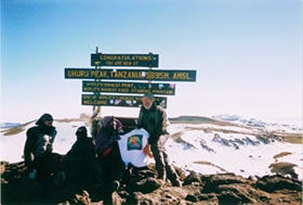
Wayne Banister, director of Business Development for bd Systems, Spatial Division, and daughter Niki, along with guides Gasper and Bernard of the African Walking Company, climbed to the summit of the highest mountain in Africa, the Uhuru Peak of Mount Kilimanjaro. Although the spirit was willing, the subfreezing temperatures at 19,340 feet prevented actually wearing the Esri T-shirt. The Uhuru Peak, called the "Roof of Africa," was the culmination of their five-day trek through the various climate zones on Mount Kilimanjaro. The actual ascent from Kibo Hut (15,000 feet) starts at midnight with arrival at Gilman's Point, the crater rim, at sunrise. |
|
Stephen C. Brown (right) and Mike Lewis
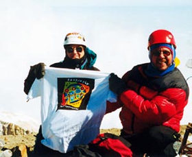
Stephen C. Brown (right), assistant professor and graduate advisor, Department of Earth and Environmental Sciences, University of Texas, San Antonio, and environmental engineer Mike Lewis (left) are pictured on the summit of the 18,500-foot Mexican volcano Pico de Orizaba. Orizaba is part of a global climate change study through mapping of the planet's glaciers. Stephen tells us that mountain glaciers close to the equator are like "mine canaries" in that they can be used to detect very small, but rapid, changes in the global climate. The photo was taken by San Antonio, Texas, attorney David Cain. |
Daniel J. Stark
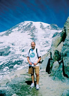
In August 2002, Daniel J. Stark, natural resource planner and GIS program manager, Fishman Environmental Services, Portland, Oregon, and his then-fianc� went to Rainier National Park to write their wedding vows. They took a hike from Paradise Lodge to Panorama Point (6,800 feet) for inspiration. Back at the lodge, they scripted the wedding ceremony and wrote their vows. They were married a month later. Under the circumstances, it was nice that Daniel thought to bring along his Esri T-shirt, here snapped on Panorama Point. |
|
Bryan and Doreen Blake
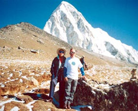
Bryan Blake, acting GIS applications manager, Transport Management Centre, Eveleigh, NSW Australia, and his wife, Doreen, spent five weeks recently in Nepal trekking in the Annapurna Ranges and the Everest Region. Naturally, he just happened to wear an Esri T-shirt. We're told that Kala Patar was breathtaking–literally, as there is approximately 50 percent less oxygen there than at sea level.
Check out more Esri T-Shirt pictures in the new expanded section below.
|
Expanded T-Shirts
 Joseph J. Kerski Joseph J. Kerski
 |
|
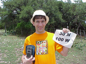
In June 2003, Joseph J. Kerski, geographer, U.S. Geological Survey, Denver, Colorado, was teaching a GIS course for teachers at Texas State University. He made a pilgrimage to latitude 30 N/longitude 100 W as part of the world confluence project (www.confluence.org)—this was in south central Texas in big game ranch country. The goal of the project is to visit each of the latitude-longitude integer degree intersections in the world and document the visits in photographs and stories. Excluding the oceans, there are still 13,565 confluences to be found! Good thing Joseph could document his Esri T-shirt as well. |
Cathy Genest Godfrey
 |
|
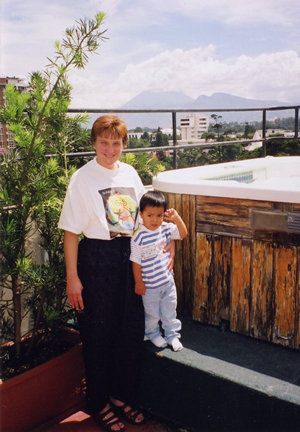
Cathy Genest Godfrey, GIS/GPS coordinator, ACRT, Inc., Cuyahoga Falls, Ohio, tells us, "This photo was taken in Guatemala City, Guatemala. That is me with my new son, Jasper. Jasper was adopted from an orphanage in Guatemala City. He is 2 1/2 years old. I was excited and nervous to become a new mother, but I still remembered to bring along my Esri T-shirt." |
Jon Hodge
 |
|
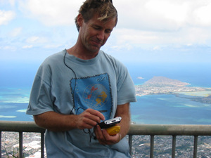
Jon Hodge, GIS analyst with the City and County of Honolulu, Honolulu Land Information System, recently went on a mission to collect GPS data using ArcPad and Trimble Pathfinder Pocket-for which wearing his Esri T-shirt was an essential part. The location was the "Stairway to Heaven" on the windward side of Oahu just above Kaneohe, Hawaii. Shown in the background is Kaneohe Bay from the top of the stairway. The hike to the top was a gruesome 3,848 steps-often straight up. |
Jeff Arnold
 |
|
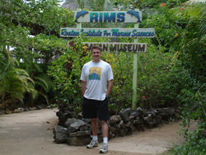
Jeff Arnold, operations manager, Center for Advanced Land Management Information Technologies, University of Nebraska, was in Roatan, Honduras, recently and had his picture taken while wearing his Esri T-shirt. At least we know Jeff has his priorities right! |
Wear an Esri T-shirt in a unique location and send a photograph to ArcNews. While digital photos sent via e-mail (tmiller@esri.com) are preferred, prints or slides can be sent to Thomas K. Miller, ArcNews Editor, ArcNews T-Shirt Feature, Esri, 380 New York Street, Redlands, California 92373-8100, USA. For additional information on this feature, contact Thomas K. Miller (tel.: 909-793-2853, ext. 1-2217).
|