Winter 2003/2004
Winter 2003/2004 |
|||||||
|
|
|||||||
Web-Based TV Inspection in Union City, California
Union Sanitary District Uses GIS for 21st Century Wastewater Management |
|||||
Located on the edge of San Francisco Bay, the Union Sanitary District (USD) in Union City, California, serves a population of 318,000 in Union City and the nearby cities of Fremont and Newark, with 103,000 wastewater connections and 760 miles of sewer lines. Many small- to medium-sized organizations, such as USD, have a common problem: how to tie numerous, sophisticated infrastructure management information systems together with GIS in a way that streamlines day-to-day operational processes, improves efficiency, and lowers costs; and how to do it with limited personnel and financial resources. Like many metropolitan areas, the tri-cities of USD's service area have been growing at a rapid pace. For years, USD day-to-day operational processes involved time-consuming manual referencing across multiple systems and data sources. For instance, field maintenance crews have had to use static map books kept in their trucks, and reprinted only periodically, to make what's underground visible. Keeping up with what's new underground is a constant challenge. BackgroundLong before a new car wash, hotel, or office complex appears aboveground, substantial work has been done in the permitting and site preparation processes, some of it, literally, underground. The exact location of a parcel, the specifications of the new lateral to the sewer main, its relationship to existing sewer lines, the depth of those lines, their size and capacity, maintenance status, and other nearby planned building development must all be reviewed before USD can issue a wastewater permit. In some cases, issuance is simple. In others, significant upgrades may be required that involve engineering for planning and design and finance for tracking new assets as they are put into the ground. Once a sewer line is in place and operational, maintenance services become essential for ongoing, low-cost operation. Knowing where pipes are physically located, the age of a pipeline, the locations of abandoned sewers, dates, locations and occurrences of spills and stoppages, complaints of odors, and the nature of repairs or corrections are all crucial to effective infrastructure and resource management. Project Start-UpThe GIS program began in 1996 with ArcInfo and ArcView on a few workstations for ad hoc mapping for engineering and other needs, and much of the time was spent on data conversion. But the USD vision was to link its systems electronically with an Intranet-based GIS, and by making accurate, up-to-date information available to the entire organization, simplify many cumbersome daily activities. Early in 2002, a request for qualifications was issued to selected firms in the GIS services marketplace. After the proposal evaluation process, Esri Business Partner MoosePoint Technology of Santa Rosa, California, was selected to consult on the project, and ArcIMS was installed on a Dell Power Edge 2550 server. In May 2002, the project started in key meetings with the USD teams responsible for collection services, commercial/residential customers, and industrial customers to define the scope of the project.
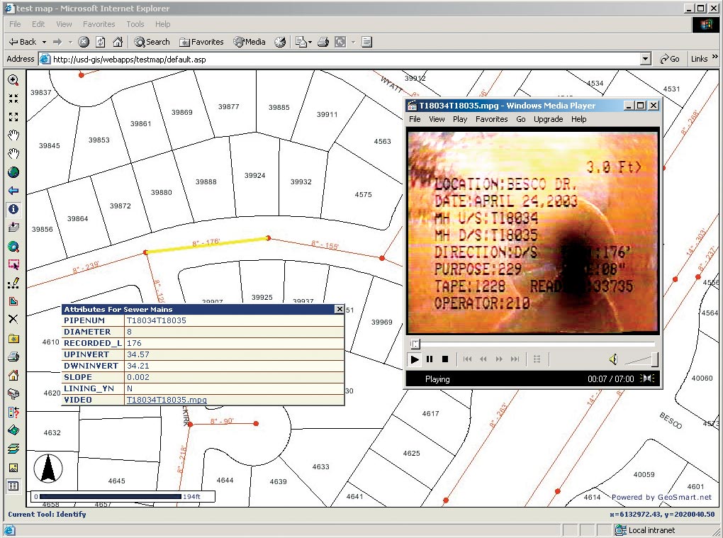
With the scope of the initial phase agreed upon, the first step was a proof of concept to link the ArcIMS mapping software directly to Esri Business Partner Hansen Information Technologies' maintenance database on an Oracle/UNIX Sun Ultra 1 server platform, where 10 years of work order and TV inspection history were stored. The Hansen Work Order (WO) data set was the first of numerous data sets in multiple databases to be accessible to ArcIMS and a companion product, Internet server-based GeoSmart.net. (GeoSmart.net is MoosePoint's proprietary Web site application builder, which utilizes a Site Builder Wizard to allow nonprogramming staff to build and maintain sophisticated Web applications.) Important for this application, GeoSmart.net connected directly to external databases and permitted their seamless integration with existing ArcIMS map services. This made it very easy when the WO database was later converted to Microsoft SQL Server on a Dell server. It also provided enhanced printing capabilities. The single architectural requirement for GeoSmart.net was that it must reside on a Web page server. For the initial phase of the USD project, ArcIMS, GeoSmart.net, and SQL Server all resided on a single server. The configuration is entirely scalable; therefore, if performance begins to lag as utilization increases, ArcIMS can be moved to its own server and then to SQL Server. Finally, Web page servers with load balancing can be added. Project ScopeThe initial phase of the project focused on delivering the top five priorities previously agreed upon within USD management. They included
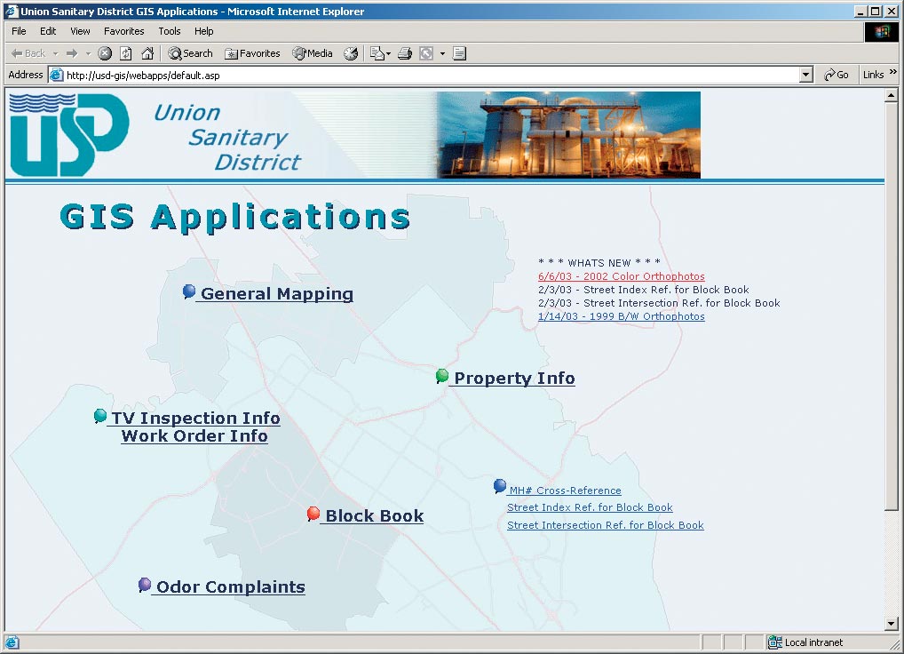
These applications were developed using the enterprise version of GeoSmart.net. Only the WO reports and TV inspection report required custom programming. A final application involved the use of ArcGIS 8.2 to allow the renumbering of all manholes based on a revised grid layout. It provides the option to select a grid block to obtain the highest manhole number in use in that block so that new manhole numbers may be assigned with the next consecutive available number. The new USD grid will be consistent with those used by surrounding cities and the water district, permitting more cooperative mapping efforts. The project was completed and delivered in late August 2002. Project ImplementationGIS Coordinator Fred Wong of USD has been careful and deliberate in designing and rolling out applications to selected user groups. With Esri's ArcIMS and MoosePoint software and a substantial number of data sets available, it was easy to create multilayered, multifunction Web site applications. All five of the Intranet applications built to date were designed to accomplish a specific functional process or task, resulting in discrete applications that are highly focused and easy-to-use. The use of GeoSmart.net technology allows these Web site applications to be easily modified and new applications easily added—with no programming skills or understanding of Internet technology needed. And, since the applications are all funneled through the same code base, migration to future versions of ArcIMS will be automatic. By linking the inspection report data in the Hansen maintenance database to the map services for mains and manholes, a common routine was simplified, the likelihood of error was reduced, and the Collection Services team's day got better. Field maintenance crews have USD's new Block Book application that allows them to identify a day's WOs and print out current, high-resolution maps of the day's work sites in minutes, assuring them of the most up-to-date information possible. For more information, contact Fred Wong, GIS coordinator, Union Sanitary District (tel.: 510-477-7635, e-mail: fred_wong@unionsanitary.com), or Dave Bishop, MoosePoint Technology (e-mail: dave@moosepoint.com, tel.: 707-566-6720, Web: www.moosepoint.com). |