Winter 2004/2005
Winter 2004/2005 |
|||||||
|
|
|||||||
The Environmental and Spatial Technology Program
Arkansas Students Trek the Land to Make a Difference for Emergency Services |
|||||
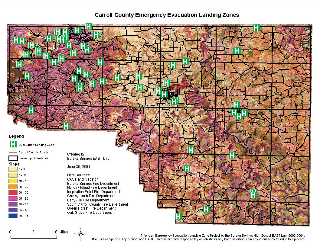
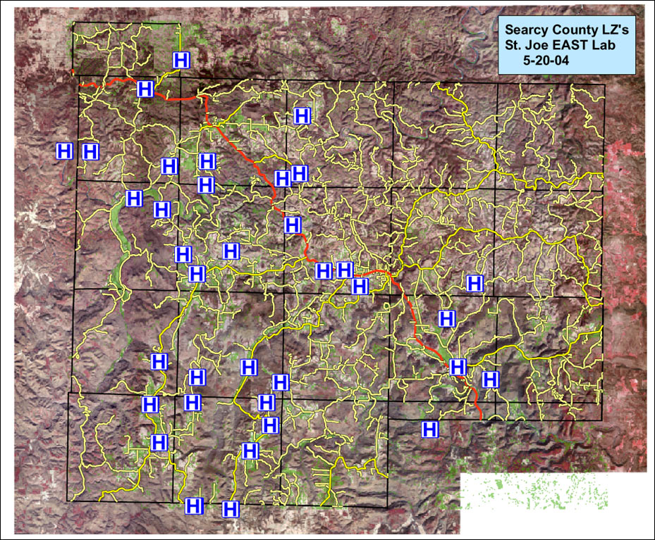
The rural area of northwestern Arkansas boasts a wooded, mountainous terrain that has enticed many to call the region home, making it the sixth fastest growing region in the United States. However, the very elements that make the area appealing also contribute to the difficulty its citizens face in a time of emergency or disaster. Boone, Carroll, Searcy, and Washington Counties make up the 3,000-square-mile region, and all are inhabited by citizens who are dependent on helicopters to evacuate the area during a natural disaster or medical emergency. In turn, the helicopters are dependent on a 10,000-square-foot unobstructed area for their landing zone. With vast stretches of land that include lakes, rivers, and hills, it is critical that emergency workers know the location of usable helicopter landing zones. Carroll County recognized the need for all public safety departments to have access to accurate and current data on all of the available helicopter landing zones in the area. Although many of these departments already had their own coordinates for local zones, there were discrepancies in their information. The Carroll County 911 Department turned to Eureka Springs High School in Eureka Springs, Arkansas, for help. Students in the school's Environmental and Spatial Technology (EAST) program were eager to help the county identify and map acceptable landing zones. The EAST Initiative is a nonprofit organization, operating in more than 200 high schools in seven states, that emphasizes using advanced technology applications to conduct community service projects. Led by Mila Powell, EAST facilitator, at Eureka Springs High School, the Eureka Springs EAST students excitedly put their skills to work for the community. The program, which covers an array of technical disciplines, included GIS/GPS projects that prepared the students for the rigorous emergency evacuation landing zone project. With a grant from the Winthrop Rockefeller Foundation and the additional forces of neighboring EAST students in Alpena, Fayetteville, and St. Joe, the students embarked on their journey across the northwestern Arkansas land armed with Trimble GPS units and ArcView and ArcEditor software. "Once we started the project, we wanted a lot of sharing of data as well as sharing of skills among the students," says Powell. "There were different lists of landing zones in the area from different sources. We set out to combine the lists from firefighters, paramedics, helicopter evacuation services workers, county officials, and 911 personnel. Our original task was to combine all these lists into a centralized database using the ArcGIS software we had already used, so we invited different people from these organizations to our EAST conference at Eureka Springs in October 2003 to explain what we wanted to do. We quickly discovered that almost all of the coordinates they had were wrong; we're talking more than 750 coordinates in Carroll County alone." The initial setback in their plans did not affect the students' purpose. Approximately eight students from each high school teamed up with police, firefighters, and other emergency personnel to visit each landing site in the four counties. Using Trimble GeoExplorer 3 handheld GPS receivers, the students began researching and mapping areas that met all the requirements of a landing zone. They used 100-foot measuring tapes, a clinometer (slope measuring tool), and the GeoExplorer 3 rovers to record the exact GPS locations. Landing zones that had obstructions were removed from the maps, and other pertinent information was collected, including the name of the landing zone; terrain data, such as slope level and elevation; names of and distance to the nearest roads and distance from trees, fences, bodies of water, and other obstacles; the addresses and phone numbers of the nearest homes; and other information that would aid emergency workers in executing the fastest evacuation. To begin the mapping process, Eureka Springs EAST students downloaded data for Carroll County, township boundaries from the University of Arkansas' Center for Advanced Spatial Technologies' GeoStor, and road data provided by the Arkansas Geographic Information Office. Using ArcGIS Spatial Analyst, the class converted elevation raster data to slope data through the Surface Analysis tool. Once they added the data, the students analyzed the information for the necessary landing zone conditions; a 100- by 100-foot area; 0 to 5 percent slope; and any possible hazards, such as trees, fences, power lines, buildings, or other obstacles. The St. Joe EAST lab found an efficient way to add all the landing zone information by creating a consolidated shapefile and adding it to the underlying map. Using the ArcEditor software's ArcCatalog application, the students corrected the coordinates until the landing zone data was correctly placed. Students, accompanied by emergency personnel, verified the coordinates using Trimble GeoExplorer 3 rovers.
"Once the students collected the necessary data, they returned to the lab and used ArcView and ArcEditor to create layered maps," says Powell. "During this process, the students not only learned how to collect the data, they also learned the GIS software necessary to create the detailed maps. ArcGIS 9 played a valuable role in the project. It enabled the students to easily learn how to use GIS technology with such comprehensive data." After the students transferred all the data into the ArcGIS application, they used the Identify tool to get the correct coordinates and create another consolidated shapefile, which was the final data of the landing zones. After adding the corrected shapefiles, students zoomed into each town, labeled the landing zones with the zone name and coordinates, and created the maps. Upon completion, they printed 8- by 11-inch and 2- by 3-foot versions of the maps for local fire and police departments, the Carroll County 911 Department, and the Air Evac personnel. Nine months after the Eureka Springs and St. Joe EAST students stepped foot into their surrounding wilderness, they completed their county map. As a result of their efforts, the county's emergency vehicles contain hard-copy maps of each landing zone complete with the name of the zone, latitude and longitude readings, and major roads and highways in the area. Landing zone wall maps for each county enable emergency services personnel to clearly locate landing zones during emergency situations. Future plans include a Web site that will contain all the landing zones for the four counties, giving local residents necessary information about the closest landing zones in their area in the event of a medical emergency or natural disaster. "This project allowed kids to work with other kids outside their normal clique," explains Powell. "They learned to appreciate and understand kids from other towns, which was one of my goals from the beginning. There was also a lot of technical sharing and interpersonal understanding. The students who knew more about GIS/GPS would guide the other students through the processes." The impact of the project has already been felt by emergency workers. "In August, I was at the county fair and a firefighter came up to me and told me that just last week they had an emergency and they used our map to find a landing zone," says Powell. "We helped save a person's life. I felt fantastic, and the kids were thrilled to know we had such an impact. It's incredible." The success of the project has prompted the community to enlist the EAST students in other important projects. The fire marshal recruited the Eureka Springs EAST students to help the city get FireWise certification. The students were asked to provide assessment teams with maps, which included houses, roads, and other information required by the program. "This program is preparing the students for a future where they'll be good, productive citizens," says Powell. "They get to pick the technology and project they work on, as long as it is helping the community. It can be a lot of work, but it is worth it when it is for a good cause." For more information, contact Mila Powell (e-mail: mlpowell@es.k12.ar.us, tel.: 479-253-2936). |