Winter 2004/2005
Winter 2004/2005 |
|||||||
|
|
|||||||
Dominion and Verizon Use Mobile GIS and GPS to Conduct Joint-Use Pole Survey |
|||
|
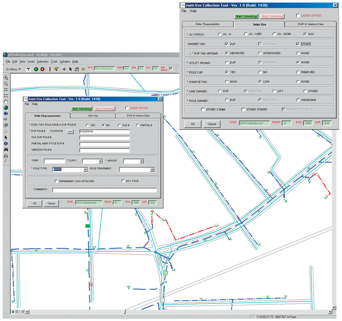
By Randy Trott, Timmons Group Dominion Virginia Power and Verizon, two large companies providing power and phone service to their clients, share thousands of poles in their combined service territories in an effort to reduce the number of poles placed in the field. Utility poles are used to attach devices (e.g., transformers) and circuit lines. Some poles are shared and have attachments from multiple companies; in the utility industry, these shared poles are termed "joint use." Pole owners gain revenue by leasing space to other companies with the amount of revenue based on the number of leased attachments. Traditionally, it has been difficult to track pole ownership, attachments, and leasing revenues.
The federal and state mandates require periodic rate adjustments associated with joint-use agreements. Utility companies must maintain accurate records of pole ownership and joint-use status for utility poles in combined service areas. Pole inventories and attachments are very dynamic. Poles are highly susceptible to man-made and natural occurrences, and once damaged, they must be replaced. Other changes can affect pole-related data: overhead circuits are often rerouted or placed underground, and new commercial and residential developments require infrastructure growth, meaning more power and phone service. Many utility companies are using joint-use surveys to update pole ownership and joint-use status to meet standards and reporting requirements. In the past, paper maps were used in the field as a guide for referencing pole locations as well as for plotting their location for future identification. Information was handwritten and converted to digital format in the office. This was a typical scenario before the introduction of mobile computers and GPS and GIS technologies. In 2001, Dominion and Verizon contracted with Esri Business Partner Timmons Group, a full-service GIS consulting firm headquartered in Virginia, to conduct a joint-use survey in their combined territories located throughout Virginia. Dominion and Verizon chose Timmons Group for its qualifications, including field crews, extensive experience with GPS technologies, and a geospatial applications development group needed to undertake this project. The survey consisted of collecting GPS coordinates and attribute information on 620,000 poles associated with 16,000 miles of service lines, using an average of 10 field technicians working at any given time. Timmons Group helped the two companies develop a method to collect joint-use and ownership data in an efficient and accurate manner. Data was captured and submitted as a final product digitally. This digital information provided a spatially enabled database and the framework for a GIS. Timmons Group deployed a team of surveyors equipped with mobile pen tablets, such as the Fujitsu 3500. These systems were chosen based on their mobility, outdoor screen readability, Windows 2000 compatibility, and ability to interface with a GPS receiver using a standard RS-232 serial port. The Trimble PRO XR Pathfinder system was chosen to fulfill the GPS component because of its ability to collect real-time corrected positions. Applications DevelopmentA crucial component of the solution was a GIS-enabled asset inventory software application based on Esri's suite of desktop applications. This solution needed to integrate with GIS and GPS and support multiple technicians collecting data in the field for long periods of time. The application component that was scoped, designed, and ultimately built allows users to view electrical devices, circuits, and other supporting GIS base layers. In addition, users are provided with a user-friendly interface to facilitate the collection of joint-use data. Data is captured in an Esri geodatabase customized to meet the business requirements of both Dominion and Verizon. Poles, number, and type of attachments were captured for all joint-use poles. This facilitated the quantification of leasing factors for any given pole in the shared service area. The joint-use collection application consists of a suite of asset inventory tools to enable field personnel to collect and store utility pole asset attributes and coordinate data collected using GPS. Visual Basic and Esri's ArcObjects were used to build a customized common object model-based extension to ArcView. A joint-use toolbar was built to house collection, query, modification, and edit tools for spatial and attribute information. Trimble Pathfinder Tools Software Development Kit (SDK) and Visual Basic were used to develop the GPS interface. The GPS receiver component handles all communications between the GPS receiver and the application, including the configuration and supply of real-time differential corrections from radio beacons and satellites. Coordinate transformation and unit conversion components included in SDK were also utilized to convert the utility data collected into the Virginia State Plane projection. The SSF Writer component was used to customize the creation of an SSF file with unique point records that could be related back to the GIS data after postprocessing and differential correction. The application provided real-time status feeds into the ArcMap application within ArcView to display GPS information, such as position dilution of precision (PDOP), differential global positioning system (DGPS), and satellite availability and position collection directly onto the custom toolbar. The Tablet PC Support for the ArcView extension from Esri was utilized to achieve redlining and gesturing functionality. Tablet PC Support interfaces enabled functionality to be built, allowing the pen motion to be stored as Microsoft INK in an annotation feature class. Application users utilized this technology to draw, circle, and note assets in the field or identify potential problems during surveying. Other functionality was built into the application using Microsoft INK technologies to, for example, allow on-screen navigation through "gesturing." Users could draw a right arrow on the screen with a stylus. This gesture triggers the current view in the ArcMap document to pan to the right. The user interface was designed based on a rule-based matrix enabling a "smart" application, which would disable attribute choices that did not follow the logic inherent in the decision matrix. This served to reduce the amount of human error associated with collecting important attribute information. Joint-use surveys typically require a high accuracy standard. This rule-base matrix approach allowed for a higher-quality end product while reducing the amount of postprocessing associated with internal quality control efforts. Prior to development of this tool, 12 to 16 hours per week were spent on quality assurance/quality control efforts. With the correct hardware in place and a mobile GIS platform, a new method of conducting joint-use surveys was established for Dominion and Verizon. The ability to collect joint-use data and GPS coordinates in the field using mobile technology improved on old methods and now enables Dominion and Verizon to update and maintain joint-use data more effectively with the use of GIS. This article was written in conjunction with the Joint Use Department at Dominion. For more information, contact Matt Gregory, GIS supervisor, Timmons Group (e-mail: matt.gregory@timmons.com). |