Winter 2004/2005
Winter 2004/2005 |
|||||||
|
|
|||||||
Iraq's Explosive Remnants of War Cleanup Is Supported by GIS |
|
|
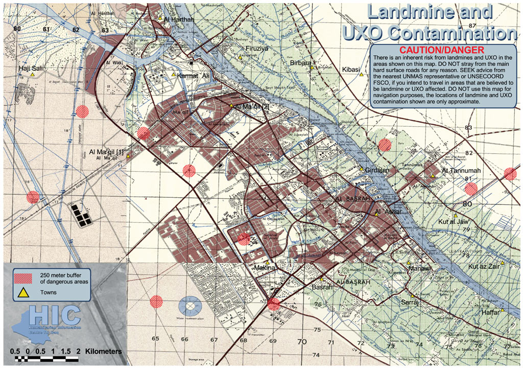
From the mountains of northern Iraq to the salt marshes of southern Iraq to the western deserts along the Tigris and Euphrates River valleys, Explosive Remnants of War (ERW) threaten the daily lives of Iraqi communities. ERW includes land mines, as well as such items as unexploded ordnance, cluster submunitions, and abandoned stockpiles of munitions, The Vietnam Veterans of America Foundation (VVAF) Information Management and Mine Action Programs (iMMAP) have been in the forefront of international efforts to define and implement field data and GIS-based methodologies for managing humanitarian mine action information. Most recently, VVAF has played a central role in efforts to define and manage such efforts in Iraq. Humanitarian mine action activity in Iraq began in 1991 and, by 2004, had expanded into a robust program in the three Kurdish-administered governorates of Dahuk, Erbil, and Suleymaniyah located in the north of the country. However, the remainder of the country was largely without any humanitarian mine action efforts until the end of major hostilities in May 2003. Humanitarian mine action (HMA) is the term used in international aid circles to define the gamut of tasks that address the impact of land mines and other ERW. HMA includes activities and programs ranging from survey, clearance, and mine risk education to victim assistance, stockpile destruction, and research and development. In Iraq, VVAF's iMMAP, under various contracts with elements of the United Nations (UN) (UN Mine Action Service, Department of Peacekeeping Operations; UN Development Program) and the United States government (Department of State, Office of Weapons Removal and Abatement; Department of Health and Human Services, Centers for Disease Control and Prevention, International Emergency Refugee Health Branch), has been the focal point for all information regarding ERW hazards. Working in Iraq and the surrounding region, iMMAP staff have collected, compiled, quality controlled, and analyzed available data. iMMAP has had three critical roles: served as a conduit for data collection, compilation, and data management from external sources; performed information management training and capacity building for the Iraqi National Mine Action Authority (NMAA); and conducted large-scale country surveys to precisely define the geographic extent and the social and economic impact of ERW in Iraq. Data ManagementVVAF's iMMAP staff were deployed to the Coalition Forces (CF) Humanitarian Operations Center (HOC) in Kuwait in early February 2003. Funded by the United Nations, as well as the United States government, iMMAP's Joseph M. Donahue was the official conduit for the release of CF bombing data for public use. In Kuwait, Donahue received periodic spreadsheets from HOC and the U.S. Army Corps of Engineers describing reported locations of cluster munition strikes, ground unit reported minefields, and other ERW hazards. These were e-mailed to VVAF headquarters in Washington, D.C., where the information was imported into ArcView, converted to shapefiles, and overlaid on Russian 1:200,000 scale maps (1:250,000 scale and larger maps were restricted from public use). These maps were compiled and posted to the United Nations' Humanitarian Information Center Web site in PDF format. Such information was critical for planning immediate clearance requirements and tasks once approval was given for aid agencies to enter Iraq following cessation of major hostilities. This steadily updated flow of information also quickly provided the basis for collaboration and cooperation among civilian and military specialists addressing the ERW hazard. iMMAP's Chuck Conley was selected to lead the United Nations Mine Action Planning Team in Larnaka, Cyprus. There, he provided technical leadership in compiling this data stream with other data sources into an initial prioritization model. The model used ArcView to buffer communities and built-up areas to create hazard indexes to classify and prioritize the initial data regarding suspected contaminated areas. In mid-May 2003, Conley deployed to Basrah, Iraq, to set up the Information Management System for Mine Action (IMSMA), as well as GIS management applications, and to establish procedures for collecting, reporting, and quality controlling HMA data from all sources. Based in the United Nations' Area Mine Action Coordination Team office, Conley also produced maps and graphics used for individual tasks to military and civilian clearance specialists throughout southern Iraq. iMMAP technical support staff continue to provide technical support at NMAA Regional Mine Action Centers in Basrah and Erbil, as well as at NMAA headquarters in Baghdad. Tools Used in IraqThe HMA community uses IMSMA (www.imsma.ethz.ch), which is the internationally accepted standard for mine action information management and is currently deployed in 28 countries. Developed by the Swiss Federal Institute for Technology, IMSMA is a front end that rests on ArcView and either Microsoft Access or SQL Server. SurveyCritical to any humanitarian undertaking is defining the problem. In HMA, surveys are used to collect, define, and validate information. In 2003, VVAF's iMMAP undertook an Emergency Mine Action Survey (EMAS) for the United Nations Mine Action Service. Covering areas of new contamination, EMAS documented the extent of this contamination, as well as the general impact upon communities. This was followed by a national land mine impact survey (LIS), currently ongoing. iMMAP Drs. Irshad Sheikh and Aldo Benini designed, structured, and fielded the protocols for both surveys. LIS will, for the first time, unify multiple data sets with data collected at the field level through processes that include community mapping exercises. These efforts will produce the first full picture of the geographic extent and severity of contamination in Iraq. LIS will allow NMAA to determine the extent and impact of contamination throughout Iraq and to prioritize assets to best mitigate this contamination. The results of LIS in Iraq will provide policy makers at the regional, national, and international levels with detailed and standardized data regarding the socioeconomic impact of land mines, unexploded ordnance, and munitions caches upon communities in Iraq. Policy makers will be able to focus efforts in the most affected areas first, and HMA specialists will be able to specifically target programs and resources for mine risk education, technical survey, marking, clearance, and victim assistance. The Iraq Mine Action Center (IMAC), the operational arm of NMAA, will participate in all aspects of the Iraq LIS that will include monitoring survey coverage and conduct and analyzing survey data. IMAC will be the primary user of the populated IMSMA database at the conclusion of this project and will utilize this data to develop a long-term national mine action strategy for the country. Capacity BuildingCritical to sustain the HMA effort in Iraq is building a culture of information management in NMAA. Such capacity building includes technical training for system operators in GIS and database functions, as well as the development of a dynamic relationship among technical, operational, and planning staff to frame questions and analyses that support the decision making process. VVAF's technical teams in Erbil, Baghdad, and Basrah provide this service in addition to ongoing technical support in managing information. VVAF's iMMAP has played a pioneering role with extensive implementation experience in the development and management of LIS worldwide. Overall, iMMAP's mission is to become an international resource for government and relief agencies that successfully integrates data into practical humanitarian plans. In this regard, the program will continue to provide technical assistance in identifying land mine clearance, as well as other social and economic priorities in postwar environments. For more information about VVAF's iMMAP and other programs, visit http://www.veteransforamerica.org/ModuleID/119. |