Winter 2004/2005
Winter 2004/2005 |
|||||||
|
|
|||||||
NASA Langley Research Center Uses GIS for "Space" Management |
|||||
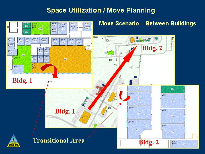
Effective space management relies on information about people, places, and processes. GIS technology helps facility managers organize and spatially visualize where and in what type of space people work. Because GIS is database driven, updates in the database are easy to visualize on a GIS facility map. GIS is able to integrate the infrastructure management with room-level detail. Based on the success of its GIS implementation for facility master planning, the GIS team of the NASA Langley Research Center (LaRC) in the city of Hampton, Virginia, has carried the system forward to handle the mammoth task of its facility's space management. LaRC has implemented an enterprisewide solution that includes a GIS-enabled Intranet and a set of Internet templates and tools to help users with their space management needs. LaRC is an 800-acre facility with approximately 400 buildings and test structures totaling 3.7 million gross square feet. Its 6,700 rooms house 4,000 employees. The center is primarily identified with wind tunnel research but supports many other disciplines, including structures and materials, flight electronics, and atmospheric science. Because of LaRC's diverse activities, the infrastructure is massive and complex with a variety of facilities. Management has been redefining the mission of the center to better meet the dynamic needs of LaRC and the nation. Consequently, the facility's infrastructure managers have been charged to make timely and efficient decisions concerning the realignment of programs and personnel. LaRC is also faced with the reality of decreased funding for operations. Thus, management needs access to infrastructure management tools and techniques that will assist it in effective decision making. The LaRC GIS Team is in the process of defining and developing software tools and applications that support these critical decision making needs. The LaRC GIS Team looks at contemporary spatial data tools as essential components for meeting five broad governmentwide initiatives: Strategic Management of Human Capital, Competitive Sourcing, Improved Financial Performance, Expanded e-Government, and Budget and Performance Integration. All of these issues are addressed by LaRC's current GIS implementation. One example is the development of a move planning GIS application that allows space utilization managers to plan and evaluate various personnel move scenarios for buildings and rooms at the center. By consolidating space, LaRC will be able to reduce dependence on buildings with inefficient operational costs while retaining and improving the coherency of the distribution of personnel within each organization. The move planning application is built on a solid GIS foundation, which was developed during the last decade. This foundation has a comprehensive infrastructure geodatabase that includes everything from utility systems and master planning to floor plan drawings with detailed information about each room. The multiuser geodatabase is stored in an Oracle database and managed by ArcSDE advanced spatial data server software. ArcIMS software is used to publish dynamic maps and data while an enhanced version of the ArcIMS HTML client, along with new serverside functionality, is used to view much of this data on the Web.
LaRC has developed a Web-based Center Master Plan portal that takes advantage of the latest GIS capabilities, facilitating access to LaRC's spatial data. The secure portal offers information that is critical to facilities planning and management. Primarily, this information includes master plan reports and documentation, workforce structure, existing facility assets and facility requirements, maintenance repair, and construction project information. Because of the breadth of diversity at LaRC, users have mixed environments that include Windows, Macintosh, and UNIX-based systems. Therefore, it is crucial to have a system that is interoperable. A modified ArcIMS viewer introduces new functionality and streamlines the user interface with emphasis on basic HTML output to ensure broad compatibility. Web tools have been defined and customized to make the majority of analysis capabilities available to any authorized user with a Web browser. This approach focuses on serverside processing that minimizes clientside processing and requirements for plug-ins. The new architecture allows reuse of map development efforts (.mxd versus .axl files), increased analysis capability, greater symbolization capability, and easier integration with CAD. The LaRC GIS Team's Web-enabled ArcIMS template is one element of a suite of tools within the supporting GIS architecture. These Web templates have been developed to support easy display of, and migration between, both plant-level data normally in a geodatabase (buildings, networks, and sectors) and building-level data not normally in a geodatabase (rooms, communication jacks, sprinklers, and panel boards). The architecture supports containment rules and mapping of features between orthographic layouts of building floor plans and associated features to the georeferenced plant-level view of all buildings and associated features. LaRC GIS Web ToolsThe LaRC GIS Team is standardizing the majority of its Web-based map services by using Esri's ArcIMS and ArcMap Server. This architecture brings many features to LaRC's Web solution, such as reuse of map development efforts (map services to be rendered from ArcGIS standard .mxd files), increased analysis capability, greater symbolization capability, and easier integration with CAD. The GIS team has been doing extensive work on designing a Web page template that will simplify online map publication. The template is intended to support all facets of Web-enabled GIS data, including LaRC building and plant data, as well as non-LaRC environments for the agency and its partners. The template is being developed using JavaScript and cascading style sheets, each of which enhances basic HTML capabilities. Some of the features available in the template include an integrated layer/legend list with automatic swatch extraction for feature symbology, date-stamped vector PDF output, simplified color definition/selection, and automatic incremental scale adjustment. Additionally, tool activation may be set for each layer and includes common visualization tools available in the standard HTML viewer. Other significant enhancements provided by the template development effort include new help capabilities, increased labeling options, and improved browser compatibility checking. Capabilities that will be addressed in future releases include output in AutoCAD-compliant .dxf format, redlining tools, metadata access/linking, statistical analysis, and area measurement. With these GIS capabilities, users can view LaRC's geography and specific information to discern facility use trends and subsequently focus on building details down to the room level in an environment where the transition between data sets is seamless. For more information, contact William B. (Brad) Ball, GIS team leader, NASA Langley Research Center (e-mail: William.B.BALL@nasa.gov). |