Winter 2004/2005
Winter 2004/2005 |
|||||||
|
|
|||||||
Model Output Data Is Available to GIS Users
NCAR Publishes Climate Change Models in Esri GIS Format |
|||
|
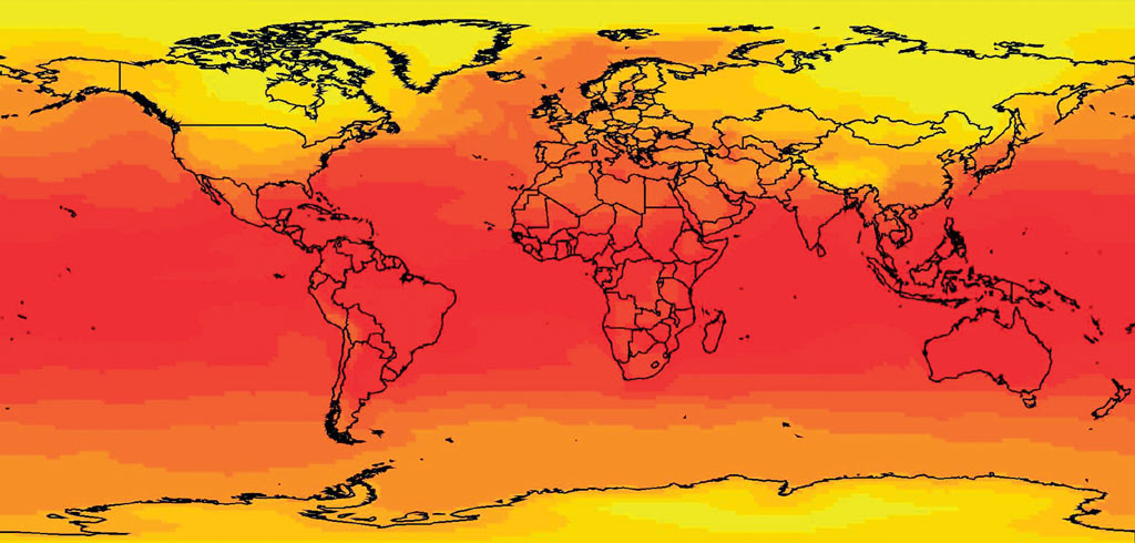
For the first time, the National Center for Atmospheric Research (NCAR) is publishing climate change model output data in a GIS format. NCAR chose Esri's data formats to bring scenarios of global climate change to scientists, researchers, educators, and planners for use in GIS software, such as ArcGIS Desktop, ArcGIS 3D Analyst, and ArcIMS.
The climate change model output data is produced by the Community Climate System Model (CCSM). CCSM is one of the world's leading general circulation climate models, a communitywide effort led by NCAR. With support from such organizations as the Department of Energy, the National Aeronautics and Space Administration, and the National Science Foundation, CCSM analyzes climatic changes using fully integrated model components, such as the atmosphere, land surface, ocean, and sea ice. Changes in climate, whether man-made or natural, involve a complex interplay of physical, chemical, and biological processes of the earth. Development of a comprehensive CCSM that accurately represents the principal components of the climate system and their interactions requires both wide intellectual participation and computing capabilities beyond those available in many institutions. CCSM provides an active program of simulations and evaluations of climatic change using an evolving model to address scientific issues and problems of national and international policy interest. Now, outputs produced as a result of the model simulations are available to anyone interested in viewing and analyzing them in a more interdisciplinary way through GIS. NCAR is pleased to bring the CCSM model output data to GIS users interested in understanding climate change and the impacts of this change. NCAR anticipates this data will provide another variable in modeling for looking at future climate when coupled with traditional GIS data, such as environmental, socioeconomic, and demographic. "Scientists at NCAR have been studying climate change and its impacts for years," says Olga Wilhelmi, project scientist with NCAR's Institute for the Study of Society and the Environment and principal investigator of NCAR's GIS Initiative. "Publishing climate change model output data in a GIS format will open NCAR climate science to a broader community of users interested in interdisciplinary issues of global climate change," she adds. NCAR is publishing this data in a GIS format free of charge at www.gisclimatechange.org. A GIS user simply needs to visit the Web site, register, and either download the data or view it on the Web using ArcIMS. Since many GIS users have not historically been able to use climate change data, there will be a host of information available on CCSM, such as climate change and metadata for different scenarios and variables. Esri and NCAR Continue Strategic RelationshipEsri and NCAR first formed a strategic relationship in 2003 to advance GIS within the realm of atmospheric research. Both organizations have been working together to explore the development of atmospheric applications, information, and data models within GIS domains. A key initiative was to provide GIS education and training for atmospheric scientists and researchers to expand GIS use at NCAR. NCAR's GIS Initiative has been busily providing seminars and a series of lectures on GIS technology and concepts and how to use ArcGIS Desktop, ArcIMS, and ArcSDE. Many NCAR employees have attended these sessions, and more seminars continue to be scheduled to accommodate the changing population of scientists. Jennifer Boehnert, NCAR's GIS coordinator, explains, "Traditionally, scientists have viewed and analyzed atmospheric data using in-house software but haven't looked at weather or climate data in a GIS context. Looking at the atmospheric data in relation to basemap data is an exciting concept." Another area of strategic alliance between Esri and NCAR is the development of an atmospheric data model for GIS. The organizations are collaborating with many other leaders in the discipline to address the creation of an atmospheric data model that will help promote the sharing of climate and weather data formats new to GIS users. A special interest group (SIG) formed at the 2003 Esri International User Conference met for a data modeling workshop at the National Oceanic and Atmospheric Administration's Pacific Marine Environmental Laboratory in Seattle, Washington, in January 2004. The goal of SIG is to extend the GIS data model to manage the representation of atmospheric data, in particular temporal and raster data. For more information, contact Olga Wilhelmi, NCAR (e-mail: olgaw@ucar.edu), or Lori Armstrong, Esri (e-mail: larmstrong@esri.com). For more information on the data model initiative or the user group and its meetings, visit www.gis.ucar.edu/sig. The second data modeling workshop is planned for January 2005 to continue efforts to support the atmospheric sciences community with the data model for ArcGIS. |