Winter 2004/2005
Winter 2004/2005 |
|||||||
|
|
|||||||
Fast, Accurate GIS Mapping Visually Enhances News Story
Newsweek Maps Out Hurricane Story With GIS and Esri BIS Data |
|||
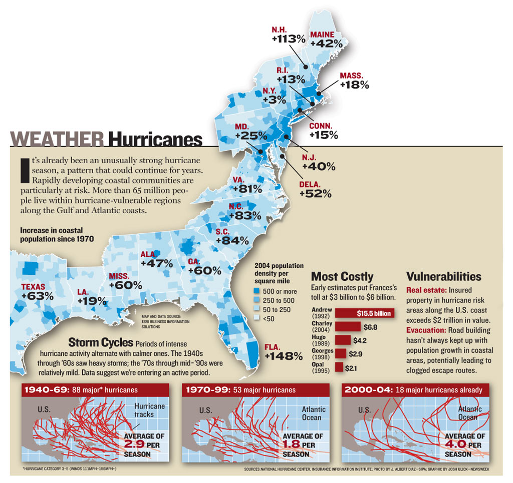
The 2004 hurricane season was devastating, with hurricanes Charley, Frances, Ivan, and Jeanne destroying property, displacing families from their homes, and resulting in numerous injuries and fatalities. For news organizations, it was a particularly important story. The enormous impact of these natural disasters could be felt nationwide in a number of ways. News coverage featured stories involving impact on lives, households, and infrastructure; how hurricane destruction impacted the political landscape; and much more. Newsweek, a leading weekly magazine with a circulation of more than three million, supplied extensive hurricane news coverage on many different but related stories. One story involved the unusually long hurricane season, the possibility of similar hurricane seasons in the future, and the potential impact this would mean for the eastern seaboard. The crucial dimension to the story: What are the population trends for these high-risk areas? Population growth in the coastal counties along the eastern seaboard and the Gulf Coast has increased the population at risk from the devastating effects of hurricanes. More people, more homes, and more businesses lay in the direct path of any hurricane that hits coastal communities. Newsweek had worked with Esri previously to provide mapping expertise. Esri provided map graphics for stories involving Hurricane Andrew, which devastated southern Florida in 1992. The successful project led to a collaborative relationship, one which ultimately spurred the magazine to again turn to Esri. "We'd done similar work with Newsweek, mapping population clusters in coastal communities in relation to hurricanes," says Darren Cook, production supervisor, Esri Business Information Solutions (Esri BIS). "The data and mapping worked out well, so we had an existing relationship with the company." Newsweek had done some research to discover that from 1970 to 1999, hurricane activity had decreased significantly compared to the 30 years before. With four hurricanes in 2004, the magazine wanted to know whether there was an increase in coastal population since 1970, and if so, exactly where those increases were occurring both by state and county. Newsweek approached Esri to perform the number crunching and visual display. The request had an obstacle: The magazine was on a same-day deadline. "One of the main problems was dealing with the immediate turnaround," says Michelle Loya, production coordinator, Esri Business Information Solutions. "We received the order at 8 a.m. Pacific time, 11 a.m. Eastern time. Because Newsweek's offices are located on the East Coast, the turnaround time frame was shortened to just a couple of hours. However, this challenge became an opportunity for us because we could quickly extract the data and produce the map, leaving time to make any needed changes that Newsweek editors required." To produce the map, Esri specialists used ArcView 8.3 and Esri BIS boundary data sets with current year demographic data. The 2004 population data sets were extracted from the Esri BIS database and joined with U.S. county boundaries. "Newsweek wanted to communicate how rapidly these areas were developing," says Loya. "To display this, I created a thematic map of current year population density. This data had to be calculated in the ArcMap application of ArcView so a quick thematic map could be created. Our lead demographer used population data from 1970 and 2004 forecasts to measure population growth for the coastal counties in each state in the region." Without Esri software and data, the search for data would have involved multiple sources. The advantage of approaching Esri BIS for the map request was that Newsweek could use a one-stop shop for its data and mapping needs, using the most current, accurate data possible and ensuring the fastest cartographic turnaround possible. "We could showcase the power of our demographic data and how easily it merges into our GIS software to produce a map for publication under a tight deadline," says Loya. Newsweek published the story in its September 20, 2004, edition. Under its Periscope Section, the story includes a color-coded map showing 2004 population density per square mile from Texas to Maine, with state-to-state percentage increases included with the county-level thematic shading. "As a magazine, Newsweek constantly works on a tight schedule with stories continually evolving," says Kevin Hand, graphic artist, Newsweek. "We needed to update an existing map from a story written a few years ago to reflect this current hurricane situation with the most up-to-date, accurate information possible. And we needed rapid analysis and print news quality. Esri provided what we wanted within the time frame needed. It was a successful collaboration that enhanced the story." For more information, contact Kevin Hand, graphic artist, Newsweek (e-mail: khand@newsweek.com, tel.: 212-445-4728). |