Winter 2005/2006
Winter 2005/2006 |
|||||||
|
|
|||||||
Making the Environment Better, One Clover at a Time
4-H Clubs Inventory Trees in Hillsboro, Oregon, and Park Conditions in St. Louis, Missouri |
|||||||||
|
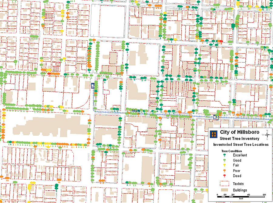
The small green clover modestly placed in the corner of every 4-H member's blue shirt symbolizes more than involvement; it epitomizes the dedication, motivation, and leadership necessary to make a positive change in communities across the United States. The National 4-H Club's countless endeavors include projects that improve environmental conditions in local communities, as well as national parks. Disappearing greenery and dwindling species are the main focus of members as they expand their knowledge of community issues and technology. In 2003, the National 4-H Program created the GIS GPS leadership team to provide leadership in promoting the use of GIS and related technologies in various 4-H programs that rely on a "learn by doing" approach. The programs develop skills in communication, community service, citizenship, leadership, teamwork, and record keeping, as well as specific content-based expertise and skills. The groups use a variety of technology, including Esri software, to make their vision of a better future a reality. City of Hillsboro Planning Department, Washington County, OregonFrom climbing them as a kid to enjoying their environmental benefits as an adult, trees are an integral part of any community. The health of a community's urban forest depends on regular maintenance (including removal, as necessary) and planting new trees. The Planning Department in the city of Hillsboro, Oregon, is developing an Urban Forestry Management plan to address these issues.
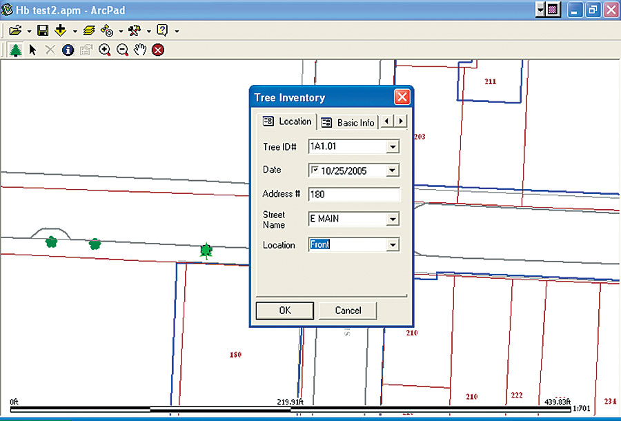
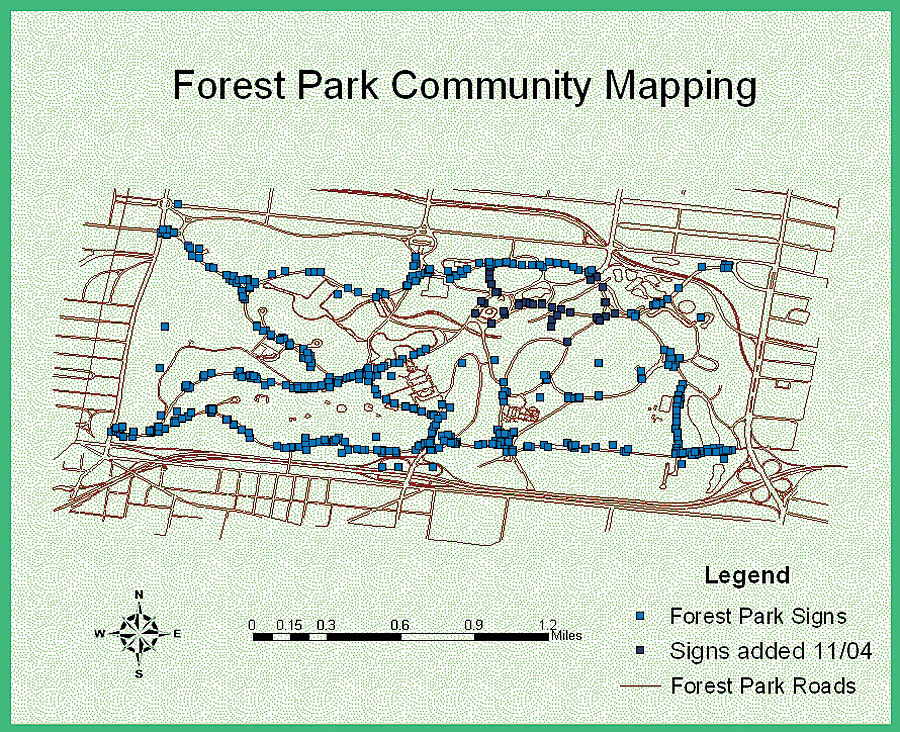
"The city is working with 4-H coordinator Lisa Conroy and the local 4-H GIS-GPS Tech Wizard youth to develop a street inventory," says Doug Miller, Hillsboro city planner. "The inventory is an important first step to understand what we have in the urban forest in order to effectively manage it." In the beginning of 2005, the city received a $4,980 grant from the Oregon Department of Forestry to conduct an inventory of street trees using community volunteers. To get the project started, Miller and the 4-Hers worked with Conroy and trained more than 400 volunteers to gather tree data, which they plan to complete in summer 2006. The youth and volunteers use ArcPad software to catalog the type, condition, size, and location of approximately 12,000 street trees in Hillsboro. "I downloaded a street tree inventory script from the Esri Web site, then modified it using ArcPad Studio so that it fits Hillsboro's geography and data needs," says Miller. As it gathers the information, the group simply loads the field data into the citywide GIS at the end of each day, eliminating the need for double entry. Once the data collection stage is complete, Miller and the 4-H members will work in ArcView to create easy-to-read maps that will help the city qualify for Tree City USA, a program sponsored by the National Arbor Day Foundation in cooperation with the United States Department of Agriculture Forest Service and the National Association of State Foresters. Tree City USA provides direction, technical assistance, public attention, and national recognition for urban and community forestry programs in thousands of towns and cities. Hillsboro sees the program as an important resource to help organize city tree management and education about tree care. The project results will also help the city identify potential hazards and plan for future budgetary needs. "This is an example of a terrific community partnership and a win-win situation for everyone," says Conroy. "The city needed help with data gathering and processing. The 4-H youth benefit from learning about geospatial technologies and careers in a real-world project, and the community benefits from having trees better selected and maintained." The group had support from several community sponsors: Hewlett-Packard, city of Hillsboro, Hillsboro School District, Intel Corporation and Foundation, Oregon State University Extension Service, PGE Foundation, the Washington County 4-H Leaders Association, and Esri. Forest Park, St. Louis, MissouriThe unique landscape of Forest Park, Missouri, boasts 1,293 acres of diverse wildlife, prestigious monuments, and historical buildings. The park, open to the public since 1876, is one of the largest urban parks in the United States, attracting more than 12 million The Forest Park activity commenced during the third National 4-H Technology Leadership Conference, cohosted by Missouri 4-H and attended by 42 Missouri 4-H youth and leaders. "A service project has always been a part of the past technology conferences," says Wideman. "With the support of Esri and the interest the youth had in GPS and technology in general, it was decided that a mapping project would be the service project."
To begin the project, the large group broke into teams and scattered throughout the park, technology in hand. The teams, consisting of four to eight people each, used digital cameras, GPS units, and clipboards to gather data about the condition of park signs, particularly around picnic sites, parking zones, and statues and monuments. Team members recorded their condition, material, distance from the curb, any obstructions in their way, and other key elements that would give the St. Louis Department of Parks, Recreation, and Forestry the necessary information to make improvements. "All the information the park requested was recorded on data sheets that allowed even the low-resource groups an opportunity to take the process home and adapt it to local projects," says Wideman. The data collection took one-half day of the three-day conference. For the remainder of the event, a group of 4-Hers learned to incorporate the data and photos into a GIS project using ArcGIS technology. Team members brought their data collection sheets into the lab and entered the data into a Microsoft Access database. The resulting data set was imported into a single database, then put into ArcView. The completed project was handed over to the city of St. Louis Department of Parks, Recreation, and Forestry to add to the Forest Park plan. "The outcome of this activity was positive on a number of fronts," says Wideman. "Forest Park and the city of St. Louis received a no-cost photographic and location survey of park signage. The 4-H youth involved were introduced to geospatial technologies and given the opportunity to practice those skills in a real-world application. GIS professionals and those communities collecting GIS data were introduced to another potential resource for accomplishing their goals." For more information about the 4-H program and to learn more about 4-H community technology projects across the country, visit www.4-h.org. More information about the National 4-H Program is available at www.fourhcouncil.edu. |