| |
The ArcWeb Services developer site allows developers to upload and interact with addresses, points, lines, and areas. |
ArcWeb Services 2006 further extend on-demand mapping and GIS capabilities for Web developers. ArcWeb Services are a rich set of Web services mapping APIs that provide developers with the ability to integrate mapping and spatial functionality into any Web-based application.
Highlights of ArcWeb Services 2006 include
- New developer APIs—In addition to enhancing the existing SOAP API, ArcWeb Services 2006 offer a Representational State Transfer (REST) API for creating maps using simple URL requests, an OpenLS API, and a J2ME Mobile Toolkit for rapid development of wireless applications.
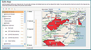
- Custom map and spatial query services—Developers can upload their own point, line, and area data. End users can then perform custom rendering and spatial queries.
- Mobile location service—Through partnerships with Sprint and Bell Mobility, the location service enables subscribing companies to locate and track their non-GPS and GPS-enabled cellular phones and send SMS messages.
- Enhanced route finder service—Developers can now build applications that route around traffic obstacles, as well as optimize the order of the route stop midpoints.
- New administration site—A new Web site is available to help subscribers easily create, customize, and administer services. This Web site offers everything developers need to get up and running with ArcWeb Services, including Web-based wizards for uploading, geocoding, and managing data; samples; tools to help administrators manage groups of users and track how many credits they have used; and much more.
Significant enhancements were made to the map image services. In addition to providing all the classic online static image formats, SVG and SWF map image formats are now available for developers wanting to directly access vector data. The new image formats offer the following benefits:
- Instant map style changes.
- Ability to identify objects on a map.
- Toggle map layers.
- True map rotation for mobile applications.
- Faster performance—no caching required for large maps.
- High quality—sharp-looking anti-aliased graphics.
The range of mapping data has also been expanded. ArcWeb Services now provide API functionality that accesses dozens of different mapping provider datasets. These data sources now include
- U.S. business pages—This dataset provides access to name, address, phone number, and SIC code for 13 million businesses across the United States.
- European Union data—ArcWeb Services now offer NAVTEQ mapping, geocoding, and routing data for the European Union.
- Reverse phone number lookup—This data allows for an address to be looked up via a phone number and a phone number to be associated with an address.
- IP and domain name lookup services—Applications can now associate general geographic coordinates to Internet Protocol (IP) addresses.
For more information on ArcWeb Services or to get a 30-day evaluation, visit www.esri.com/arcwebservices or call Esri at 1-800-447-9778. Outside the United States, contact your local Esri distributor.
|
