Winter 2005/2006
Winter 2005/2006 |
|||||||
|
|
|||||||
Valuable Natural Resources Managed with Modern Technology
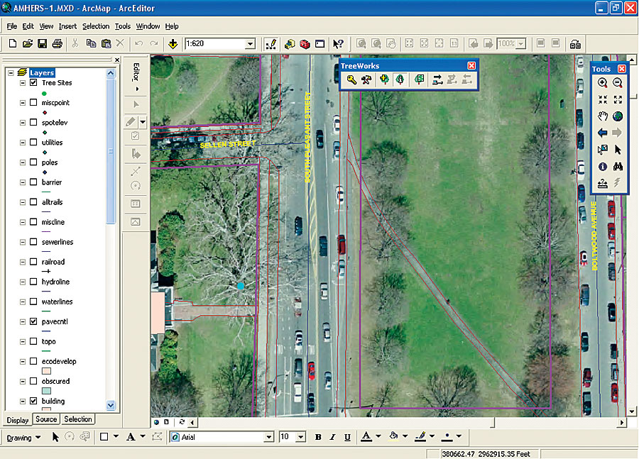
Cambridge, Massachusetts, Community Trees Are Managed with GIS |
|||
One of the original puritan settlements of 1630, Cambridge, Massachusetts, is one of the most historic cities in the United States. The home of the United States' first university, it is a culturally diverse community of approximately 100,000 people where college students from around the world study at Harvard, Radcliffe, the Massachusetts Institute of Technology, and Lesley College. Despite containing some of the most technically and intellectually innovative industries, universities, and research facilities, Cambridge holds to its New England charm and beautiful tree-lined neighborhoods. Some of these trees might have even played important historical roles—for example, in the myth that George Washington took command of the army in Cambridge on July 3, 1775, under an elm tree. The myth of Washington and the elm is still widely known today, and the image of the tree remains a symbol of patriotism in Cambridge. Today, thousands of trees, some of which date back to the 1800s, line the streets of Cambridge and someone has to manage these valuable assets. This responsibility falls to Kelly Writer, the city arborist for the Cambridge Department of Public Works (DPW). The challenge is that trees are living organisms and require maintenance; protection; and, eventually, replacement. Another constant issue for the urban arborist is the identification of hazards—such as dead branches that overhang parking spots, streets, or sidewalks—and the remedy of these hazards in a timely manner before they cause injury or damage to property. "We needed a detailed and comprehensive street tree inventory to track species, size, location, and tree condition," explains Writer, "but more important, this information needed to be easily accessible for managing the maintenance priorities of the tree crews." DPW completed tree inventories in the 1980s using stand-alone software, but it found this data ineffective. "It was difficult to access," says Writer, "and we needed an easier way to manage our trees that was flexible and powerful and worked seamlessly with our existing ArcGIS system." He turned to the Kenerson Group, an Esri Business Partner, to provide the solution. The Kenerson Group had developed TreeWorks, a community tree management software extension for ArcView. Writer was introduced to the software at a Massachusetts Tree Warden conference where he learned of its ability to efficiently produce an ArcGIS software-based street tree inventory integrated within Cambridge's existing digital mapping environment. The software's tree maintenance data could also be linked with DPW's server-based organization-wide work order system. Upon the recommendation of a colleague, Writer invited the Kenerson Group to provide a demonstration for him and Eric Josephson, DPW's GIS manager. They ultimately decided the software would be a good fit and installed it in the summer of 2005. Since the installation on a Dell OptiPlex 280 desktop PC, Writer's staff of four has inventoried more than 4,000 street trees in about one and one-half months. Josephson uses ArcView to delineate work areas, and staff arborists are sent out to the target neighborhoods. The arborists use Hewlett-Packard iPAQ 2415 handheld computers (PDAs) running ArcPad, TreeWorks Mobile with street and building layers, and a high-resolution color aerial photo of Cambridge to collect the individual street tree information. The selected neighborhoods were easy to navigate on the PDA screen, and the high resolution allowed the arborists to identify individual trees on the photo. The trees are located in the field and accurately mapped in the ArcPad tree layer. The arborists then enter the site information, tree attributes, and maintenance information into dialog boxes that store the data in linked tables. Upon completing the day's inventory, the arborists bring the PDAs back to the GIS office and connect them to the main computer, and the newly collected data is automatically synchronized with the master TreeWorks database on the base computer. After the synchronization process, the PDAs are ready for a new day's inventory. The Cambridge tree inventory (about one-third finished as of this writing) has already become an invaluable tool for both DPW and the city's residents. According to Writer, at a recent neighborhood meeting, residents expressed their concern over street tree maintenance. "They wanted to know what system was in place to prioritize tree care issues, such as planting; tree stump removal; and hazard identification, for example, locations where tree roots are lifting sidewalks and driveways—a situation especially important to the elderly," relates Writer. "The arborist staff had just inventoried the trees in the concerned neighborhood, so I was prepared with comprehensive maps and data showing the exact location of the trees; their condition; and, to the satisfaction of the residents, a time frame for addressing identified problems." "GIS systems provide a great advantage in protecting our natural resources, wherever they are located—in cities or the countryside and in natural or man-made environments," concludes Writer. "The Cambridge DPW now has access to better, timelier information, and better information always leads to better decision making." For more information, contact Kelly Writer, city arborist, Cambridge DPW (tel.: 617-349-4800), or John Clarke, Kenerson Group (e-mail: jclarke@kenersongroup.com, Web: www.kenersongroup.com). |