Winter 2005/2006
Winter 2005/2006 |
|||||||
|
|
|||||||
Defining the Components of the Geospatial Workforce—Who Are We? |
|||||
|
Continued... In addition to the general areas identified above, there is a frequently overlooked but very critical supply-side component that must also be addressed when defining the scope of the geospatial workforce. That is, the relevant educators and trainers whose combined efforts result in the creation of new entries into the geospatial workforce and in the continuing technical education and training of existing geospatial workers. Failure to explicitly consider the factors influencing the quantity and quality of these particular workers ("training the trainers," etc.) can easily result in a significant, negative impact upon any geospatial workforce quality and quantity goals that may be established. A Previous Definition of the Geospatial IndustrySeveral years ago, it was suggested that the geospatial industry be defined as
This older and rather awkward definition is more than a bit misleading since the geospatial industry, while a heavy user of information technology, is certainly not derived from that field and cannot realistically be considered to be a subdivision of information technology (IT) any more than can, say, the modern banking industry. Referring to it as a "field of practice" produces a focus only on the "utilization" aspect of the industry, and extending the definition to include the limited development of IT tools admits only a portion of the "tool construction and testing" aspect of our broader interests (it excludes, for example, the development of new remote-sensing and surveying instruments). While the domain of discourse must be carefully defined, any working definition that we do adopt certainly needs to be far more representative of where we come from and what we do. Toward Working Definitions of the Geospatial Industry and Its WorkforceTo hopefully initiate further discussion on the topic, let me suggest the following strawman definition of the geospatial industry. This draft definition needs to be discussed at some length, and modified as necessary, by those involved in or having a major concern with the geospatial industry.
The notion of relevant scales is not commonly encountered in industry definitions, but its insertion here reflects the comment made some years ago by Dr. Michael Dacey, a geographer, that a primary difference between the disciplines of physics, geography, and astronomy was a matter of their respective focus upon different segments of the scale continuum. We have no problem with geospatial investigations of various planetary objects, but we do not "do" astronomy. On the other end of the scale continuum, we increasingly work at submeter levels and some of our analytic tools (map projections, spatial statistics, etc.) are even being applied at the molecular level.
Omitted from my strawman definition of the geospatial industry is any explicit mention of the "use" of the products that are created. My rationale here follows the general notion of excluding from, say, a definition of the banking industry, the users of checking accounts as opposed to workers providing these accounts. However, in a geospatial context, the situation is far more complex. Within what we might identify as a "class" of geospatial users who focus on activities, such as analysis, visualization, interpretation, and management with a primary focus on problem resolution, we find a substantial degree of technical differentiation ranging from, say, the operation of a high-end integrated GPS/GIS dispatching system on the one hand to an individual looking for the location of a local business. In my own opinion, the first is clearly "in" and the other clearly "out." However, questions such as these need to be discussed at some length by all of those concerned. Within the context I have suggested for the geospatial industry, I would suggest that the definition of the geospatial workforce be limited to those individuals who are employed within the industry, or who act as contractors to the industry, on either a full-time or part-time basis and whose position involves the need for some specified level of technical knowledge. What level? Again, a topic to be debated. The upper end of the skill spectrum does not really need to be carefully defined, but the lower end must be examined with some care. The difference between, say, a general secretary and a legal secretary in terms of specialized skills is generally accepted. Are similar distinctions present in the geospatial workforce? If so, we need to identify them. Is Anything Currently Being Done with Respect to These Concerns?There have been several mentions of the need for give-and-take focused on the development of working definitions of the scope of the geospatial industry and its workforce. Are such discussions going to take place? I am pleased to note that they are already beginning. The Employment and Training Administration of the U.S. Department of Labor recently made a substantial award to the Geospatial Information & Technology Association (GITA) (www.gita.org) and the Association of American Geographers (AAG) (www.aag.org) to begin discussions on these definitional topics with a large group of organizations and individuals. In addition, the two organizations will develop a pilot Web-accessible server of geospatial industry, job, and educational information called GIWIS. When we finally have workable definitions that effectively define the bounds of the geospatial industry and its workforce components, we will be in a much stronger position to forecast future demands for specific workforce categories and to identify the specialized knowledge, skills, and experience that are needed by workers in each of these groups. This information will also prove valuable in more clearly focusing the ongoing attempt by the University Consortium for Geographic Information Science (UCGIS) (www.ucgis.org) to identify viable modern undergraduate curricula in the area of geographic information science and technology (GIS&T). We will also be able to develop certificate and in-service training programs that will provide more effective in-service knowledge and skill updates to members of the existing geospatial workforce. With the required structural elements in hand, we will be in a position to begin building a much more substantial and accurate picture of the geospatial industry and its future growth and workforce requirements. But what data is currently available to support such an effort? What Do We Currently Know About Who Is Involved in the Geospatial Industry?In terms of either organizations or people, regretfully, a great deal less than we really need to know at this point. From an organizational standpoint, the term "geospatial" or almost anything resembling it fails to appear in either the 2002 version of the North American Industry Classification System (NAICS) or in the revisions that have been adopted for the 2007 version. The only specific codes that appear at all relevant are 54136 Geophysical Surveying and Mapping and 54137 Surveying and Mapping (other than geophysical). This means that there is relatively little in the way of current industry statistics that can be extracted from existing government tabulations. We are not even in a position to select a limited number of NAICS codes and attempt to call the result "geospatial" since our activities touch upon so many different NAICS codes. The question of "membership" in the geospatial industry is further complicated by the fact that many of the creators and users of geospatial technology and data are governmental and nongovernmental organizations and that within these, as well as within most private sector companies, only a portion of the organization normally deals directly with geospatial technology and its products. Currently, we are unable to identify the extent of the involvement of any specific organization without utilizing our yet-to-be-determined domain definition and then engaging in the primary acquisition of the necessary organizational data.
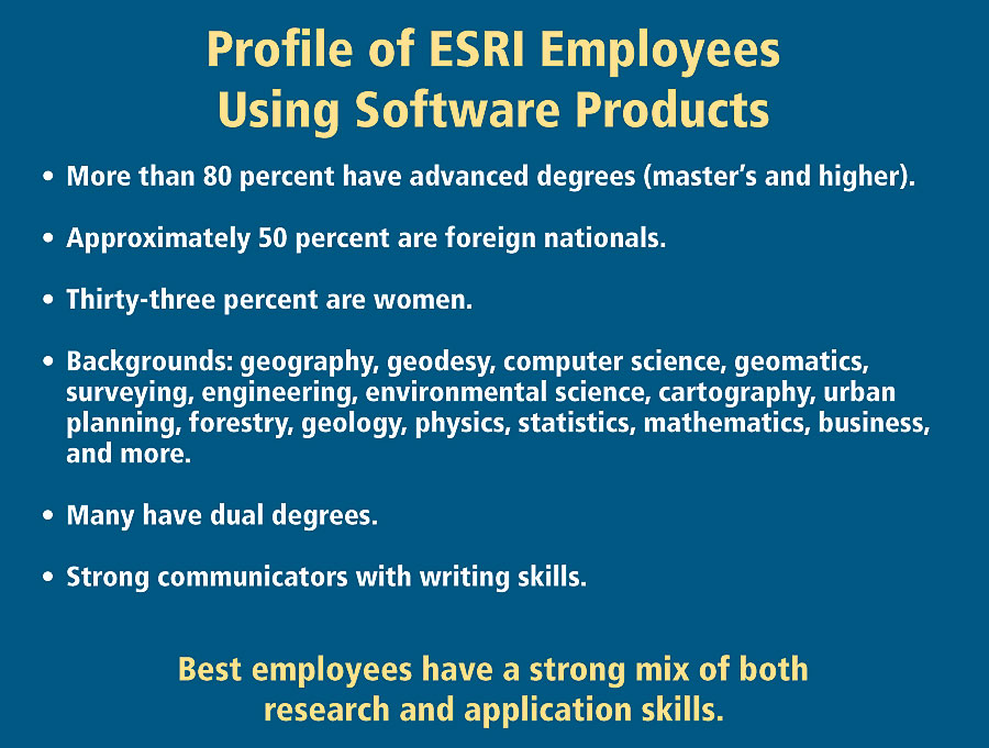
Given the difficulties encountered in establishing membership criteria and then the need to make an "in or out" decision with respect to individual organizations and their components, it is not surprising that we currently have only minimal knowledge of the existing geospatial workforce. We are unable to speak in any definitive way even to questions of simple demographics, such as the composition of the geospatial workforce by age, gender, race, citizenship, duties that they perform, or the locations where they work and reside. We also know little on an industry-wide basis about current job descriptions, educational backgrounds, and what knowledge and skills are needed and desired for each position, etc. An interesting example of some of the kinds of things we should know on an industry-wide basis may be found in a presentation given by Clint Brown, Esri's director of Software Products, in San Diego, California, in July 2005 at the Esri Education User Conference. Esri Software Products works closely with Software Development and currently employs just over 200 workers. One major component of Esri's participation in the geospatial industry lies in the tool constructing and testing category identified earlier. Such activities clearly require an advanced level of education and training compared to, for example, organizations whose primary concern is with more routine application of existing geospatial tools. Two illuminating slides from this presentation are shown here as figures 2 and 3. Figure 2 provides a brief profile of the employees in Esri Software Products; of special note are the number of individuals holding advanced degrees (80 percent), the high proportion of foreign nationals (50 percent), and a significant number of women (33 percent). Also of importance is the very heterogeneous disciplinary background of the employees, including many who hold dual degrees. In figure 3, we see a list of some of the general skills that are considered desirable for work in this area. Prominent here are advanced knowledge and experience in both GIS concepts and computer and information technology. In light of the item mentioned at the bottom of figure 3 (problem solvers), it is interesting that in informal discussions I have had with a large number of users and developers of geospatial technology they stress the extreme importance of their workers' ability to
Often, these skills appear to be valued far higher than the individual's manipulative skills with existing geospatial software. In my estimation, this reflects both the complexity of many geospatial problems as well as the continuing rapid development and increasing sophistication of the tools that are being applied to the solution of these problems. What Do We Need to Do?As perhaps part of, or hopefully following closely on, the GITA/AAG study, a number of things need to be done as rapidly as possible if we are to effectively deal with the workforce problems generated by a rapidly expanding geospatial industry. The sequence in which the following activities are approached is also important since they are dependent upon each other.
In ConclusionWe have reached the point where we are clearly being hampered by the lack of a firm notion of just what makes up the geospatial industry and exactly what will define our future technical workforce requirements. It is my firm belief that failure to address these concerns in the very immediate future will lead to long-run difficulties of considerable magnitude. With respect to the geospatial workforce, failure to begin making preparations now for our future needs is highly likely to not only impede the continuing growth of the geospatial industry but also to have serious impacts upon society as a whole. What can you or your organization do? Certainly you should participate as fully as possible in the ongoing GITA/AAG study mentioned here. Do you have existing workforce information (such as that seen in figures 2 and 3)? If so, share it (on a confidential basis if necessary) with the ongoing GITA/AAG study since it appears that we will have to build our initial view of the workforce from such bits and pieces. Check with your local institutions of higher education. What are they doing in the area of geospatial education? Is it relevant from your point of view? Become involved with their geospatial educational programs and encourage them to address the questions of breadth and depth raised here. For more information, contact Dr. Duane F. Marble, Castlereagh Enterprises, Inc., Florence, Oregon 97439 (e-mail: dmarble@OregonFast.net). Note Reference |