Winter 2005/2006
Winter 2005/2006 |
|||||||
|
|
|||||||
First Esri Asia-Pacific User Conference for Esri Users |
|
|
The First Asia-Pacific Conference for Esri Users, hosted by Esri China (Hong Kong) Limited, was held January 12–13, 2006, at Cyberport, Hong Kong, China, with great success and Plenary SessionThe plenary session was officially opened by Dr. Winnie Tang, CEO of Esri China (Hong Kong). Tang said that this first conference for GIS users in the Asia-Pacific region showed Esri's commitment to GIS users in that part of the world by bringing attendees the latest technological development and applications of GIS, as the theme of this conference—GIS Sustaining the World's Fastest-Growing Region—suggested. Following her welcome speech, the two officiating guests, John C. Tsang, JP, secretary for Commerce, Industry, and Technology, the government of the Hong Kong Special Administrative Region (HKSAR), and Chung Kai Sin, JP, Hong Kong legislative councilor, IT Industry, delivered their welcome speeches. "Hong Kong has benefited from the increasing adoption of GIS and associated mapping applications in both the public and private sectors," said Tsang. "This conference is a good platform for government departments, GIS professionals, and users to share ideas, experiences, and best practices of GIS technology and its various applications in the Asia-Pacific region. We are also looking forward to learning from participants' insight on the wider use of geospatial data by the community in this conference."
Keynote SessionThe inspiring and well-received keynote speeches were delivered by five prominent speakers from industry and academia in both the international and regional domains:
Panel discussions took place after the keynote speeches, and the insights from keynote speakers and industry leaders framed the discussions of the participants in identifying ways to address the theme of the conference. Maguire was the moderator of this session, whose Welcome ReceptionMost of the participants stayed for the welcome reception to socialize and network with other speakers and attendees. The reception started with welcoming remarks by Maguire, followed by a welcome speech by Michael Phoon, director, Large Format Printing, Asia-Pacific and Japan, Hewlett-Packard (HP) Asia Pacific Pte Ltd., Imaging and Printing Group—the Platinum Sponsor of the conference. User Presentations and Technical WorkshopsThe second day of the conference featured paper presentations and technical workshops. The presentations covered a wide range of topics, including environmental management and nature conservation, urban and regional planning, transportation and logistics issues, education, national and local government, disaster prevention, natural resources, sustainable development, facilities and infrastructure management, and utilities. The speakers came from many industries in public, commercial, and academic sectors. All the sessions received excellent feedback from the participants. The main highlight of the user presentation sessions was the Directors' Track. Four directors from departments of HKSAR presented—Chiu Ying Lam, director of the Hong Kong Observatory; Patrick L. C. Lau, director of Lands; Hing-Wang Fung, commissioner for Census and Statistics; and Bosco C. K. Fung, director of Planning. Four technical workshops were led by Esri professional staff. Participants enjoyed these workshops and found them very useful in learning the latest technological development of Esri's GIS products. Exhibition and Map Gallery
Gala Dinner
For more information, contact Queenie Wang, Esri China (Hong Kong) (e-mail: qwang@esrichina-hk.com). |
 exceptionally high attendance. Participants from 20 different Asia-Pacific countries and regions came together at this inaugural conference to share ideas, experiences, and best practices of GIS and its various applications for sustaining our world.
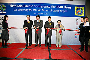
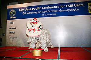 The opening ceremony featured the traditional Chinese lion dancing performance and ribbon-cutting ceremony to inaugurate the conference. Following this ceremony, Dr. David Maguire, director of products, Esri, delivered an opening speech. Maguire shared his view on technology developments and the role of GIS in sustaining the development of this fastest-growing region in the world. It was followed by a demonstration of the latest GIS technology, conducted by Esri's John Calkins, Lindsay Hernstrom, and Peter Becker.
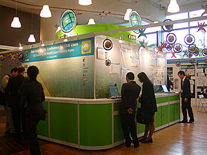 panelists were Batty, Chen, Lewis, Lightner, and Yeh. Participants showed keen interest in the discussion. This session certainly created new interest in GIS and its role in sustaining the world's fastest-growing region. Many questions were received from the floor.
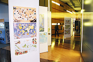 An exhibition and map gallery were held during the conference. Sponsors and exhibitors were hardware vendors, service providers, and GIS-related companies in the Asia-Pacific region, including HP, Microsoft, National Conference Services Inc., and seven other Esri business partners that supported the conference. The Map Gallery featured an amazing collection of maps and posters provided by the National Geographic Society. The Exhibition and Map Gallery drew a large number of visitors to the booths and map displays; the Esri China (Hong Kong) booth, in particular, was a popular attraction throughout the two-day conference. Many new GIS technologies were showcased, including mobile and wireless GIS, a preview of ArcGIS 9.2, Web GIS applications, and image processing and management, as well as some real-world GIS applications in Hong Kong. Visitors could touch and examine the latest Esri and other related GIS technologies.
 After two full days, attendees gathered at the gala dinner in a relaxing and pleasant atmosphere to celebrate the successful conclusion of the conference. The gala dinner was held in the premier floating restaurant of Hong Kong, the Jumbo Kingdom Restaurant. The guest of honor was Michael M. Y. Suen, GBS, JP, secretary for Housing, Planning, and Lands, HKSAR. The close of the conference was marked by Maguire extending his special thanks to all participants and sponsors who made the conference a success.