Winter 2005/2006
Winter 2005/2006 |
|||||||
|
|
|||||||
Providing a Helping Hand for Mississippi Counties
Florida State Emergency Response Task Force Provides Hurricane Katrina Support Using GIS |
|||||
|
Hurricanes Katrina and Rita caused GIS specialists, along with countless others in health, emergency services, disaster response, law enforcement, fire, government, and more, to come together and respond to the devastation left in their wake. Yet it was not only those who lived within the affected region who responded; others who were outside harm's way chose to do what they could where they could. One example includes Florida response teams that truly made a difference.
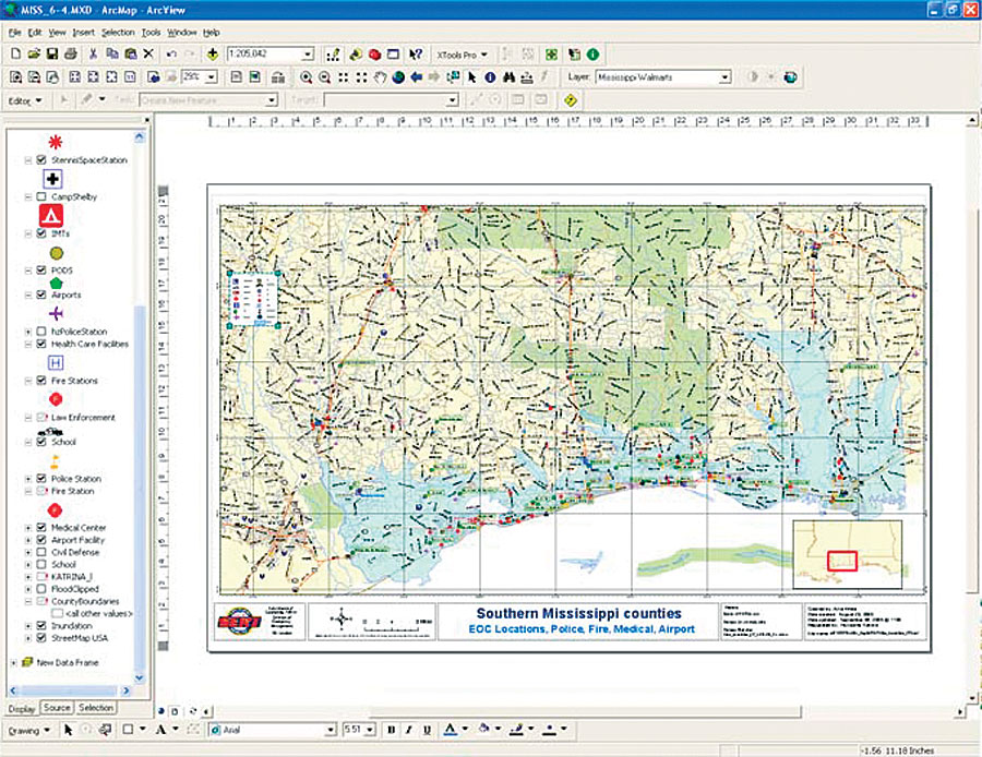
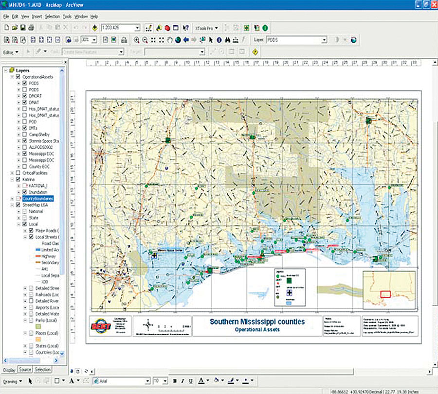
The Florida Department of Emergency Management (FDEM) and the Florida State Emergency Response Team (Florida SERT), in conjunction with Mississippi state officials, made the decision for Florida SERT to adopt the lower six Mississippi counties; the 3,000-member Florida team had moved into position at dawn following the storm's landfall. The Florida SERT base camp was a staging area for staff members to serve relief personnel including firefighters, law enforcement, and the military. Part of the initial team included a three-person GIS crew that was supported by a six-person GIS team in Tallahassee, Florida. Two of the three GIS crew members were volunteers. Florida SERT utilized GIS technology to help improve response, planning, and incident command during its operations in Mississippi. GIS helped the SERT personnel quickly become oriented with the surrounding areas; understand the location, nature, and extent of the disaster; and gain a comprehensive understanding of the emergency. "During activations, my role and the role of my staff," says Carla Boyce, GIS administrator, Department of Community Affairs, Division of Emergency Management, state of Florida, "are to use all available technologies and best practices to disseminate intelligence and promote a common operational picture for all responders, regardless of physical location or role in the response. In addition, it is our job to ensure that we cull the excess data and direct pertinent information to the end user effectively and efficiently. GIS is an invaluable tool in creating situational awareness and is essential in disaster preparedness, response, and recovery." PreparednessFDEM is the lead agency in the state of Florida for disaster preparedness, response, recovery, and mitigation and is part of the Department of Community Affairs. Florida SERT is made up of a broad cross section of stakeholders from state agencies and county governments to private enterprise and nonprofit groups. Boyce serves as leader of the Spatial Technologies and Information Management Lab for FDEM, which has extensive hurricane response experience. The team worked during the 2004 hurricane season to provide GIS support and administer the GIS programs for hurricanes Frances, Ivan, and Jeanne. Prior to Katrina touching land, Florida SERT had prepared an Urban Search and Rescue (USAR) contingency plan for western Florida in the event the storm did not follow its predicted track. Florida's preparation for Hurricane Katrina's landfall left Florida SERT well positioned to aid neighboring states. Because of the forecasted hurricane track, the USAR leaders had the Florida SERT GIS crew prepare as much data and map products as possible for the Mississippi and Louisiana areas. Boyce had already been in touch with Mississippi state GIS staff and had begun to acquire critical datasets prior to losing communication with the Mississippi and Louisiana servers during Hurricane Katrina. Critical datasets acquired included location of county Emergency Operations Centers (EOCs), fire/rescue facilities, hospitals, nursing homes, and other critical facilities, as well as demographic data and population density. This information was used to help identify critical facilities that would likely be impacted and need significant support. Demographic information was used to begin logistical planning for the acquisition and staging of commodities (food, water, ice). Road networks, utilities, hazardous materials sites, and more were obtained to aid responders in mission planning and safety. GIS SupportEsri South Florida staff were among the Florida SERT members to provide GIS support services. They set up a mobile command vehicle, which was the place where GIS activities happened. Computers, a satellite Internet link, satellite telephones, software, plotters, and other resources were in place and being used by staff immediately after the hurricane swept through and continued to be used as a response tool. Thousands of maps were generated and used in every possible aspect. This vehicle served as the physical location of the Mobile Command EOC until another site was secured. Esri staff and the EOCs used ArcGIS Desktop (ArcInfo and ArcView) with the HAZUS extension from the Federal Emergency Management Agency.
As Florida SERT began supplying hurricane response services, GIS staff started providing all types of spatial data management, analysis, and map output. Thousands of maps were generated and dispersed among responders. Many of these consisted of road maps with logistics information added at various scales and sizes. Most data was supplied from either internal or freely available government sources. According to Boyce, GIS helps people understand any emergency threat or event as it relates to the part of the world affected, including at-risk populations, critical facilities, infrastructure, and more. "When these things can be identified even before an event occurs, much planning and logistics can be accomplished that will increase the speed and timeliness of a response," says Boyce. "Spatial awareness also assists in search and rescue operations. Using remote-sensing techniques and spatial analysis can streamline or focus USAR teams' approach, making them more effective. This is how we were working in response to Katrina." Initially, the hurdles that had to be overcome by GIS staff were logistical: finding space to set up operations, securing Internet connections along with phone and satellite throughputs, and locating the proper hardware and plotters needed. These were quickly solved as staff worked furiously to locate the right equipment and get items up and running. Once the GIS architecture was ready and maps were finding their way into the hands of hundreds of Florida SERT staff, more people became aware of the GIS capabilities available and more requests came in. Maps to fueling stations, direction maps from command operation centers to forward Emergency Operations Centers, maps of downed infrastructure—all types of requests came in and increased over time. As teams deployed throughout the region, new and updated maps were produced with ArcGIS and distributed digitally using digital collaboration software called Groove Virtual Office. The mobile command vehicle, with its satellite communications, and the Groove Virtual Office allowed large files and GIS data with updated maps to be sent to forward teams until the teams were up and running on their own. The forward teams would then send new and updated spatial and tabular data back to the command center for constant information renewal. Road maps of New Orleans also helped military units based in Florida quickly become oriented with the surrounding areas they would begin serving. In addition, basic directions and latitude/longitude coordinates were provided for people going into the field. Many of the lead Florida responders had GPS in their vehicles, so if they had latitude/longitude coordinates, they could find objects and locations faster and with greater ease. Field personnel would then provide GIS staff with GPS coordinates to update maps for logistics sites. Florida SERT continued to provide services until September 28, 2005. The team's deployment helped Mississippi in the devastating aftermath of Hurricane Katrina and demonstrated the importance of regional collaboration across states and agencies. "We did our best to help where we could when we were asked," says Boyce. "There were many different individuals who did a remarkable job of getting up and running with incredible speed to provide hundreds of maps for people directly involved in the initial response. We were fortunate enough to be in a position to assist in this enormous effort." "Some of the first people on the scene in Mississippi were from the state of Florida," says Rob Hofmann, South Florida manager, Esri. "Our people set up shop the day after the storm. We were basically up and running and generating maps and data by that afternoon. Our primary concern was providing basic theater of operations maps to support the Florida staff members on scene, which included fire, EMS, forestry, police, logistics, and other personnel." For more information, contact Carla Boyce, GIS administrator, Department of Community Affairs, Division of Emergency Management, state of Florida (tel.: 850-413-9907, e-mail: carla.boyce@dca.state.fl.us). |