Winter 2005/2006
Winter 2005/2006 |
|||||||
|
|
|||||||
Mexico's National Center for Disaster Prevention Delivers Natural and Human-Made Risk Information to the Web via GIS |
|||||
|
From its high rugged mountains to its coastal plains, Mexico is a vast and varied country. Spanning nearly two million square kilometers, it is Latin America's third largest nation after Brazil and Argentina. Sharing its borders with the United States to the north and Guatemala and Belize to the south, Mexico's geographic diversity is a function of its north/south position spanning the tropic and subtropic latitudes and its great range in altitude. The topography varies from dry alpine tundra and low desert landscapes to humid tropical jungles and coastal plains. This expansive environment is host to a variety of natural hazard potentials, including volcanic activity and earthquakes in the center and south of the country; hurricanes on the Pacific, Gulf of Mexico, and Caribbean coastlines; and tsunamis along the Pacific Ocean. In the past few decades, Mexico has been severely affected by natural hazards, most recently by Hurricane Wilma. In 2002, the Mexican President's Office and the Ministry of the Interior approved the Special Program for Risk Disaster Mitigation in Mexico. President Vicente Fox has considered this program, the purpose of which is to address the need for improved public safety and risk mitigation in the face of natural disasters, to be one of the most important during his administration. In January 2002, the National Center for Disaster Prevention (Centro Nacional de Prevencion de Desastres, or CENAPRED) initiated the National Atlas of Risks project to support the special program. The resulting Mexican Atlas of Risks delivers natural and human-made risk information of the entire country via a GIS-based Web site (www.atlasnacionalderiesgos.gob.mx). It is tailored for the general population so that citizens can be aware of the types and levels of risks in their communities and for civil protection authorities to help them develop preparedness programs, emergency plans, and reconstruction procedures.
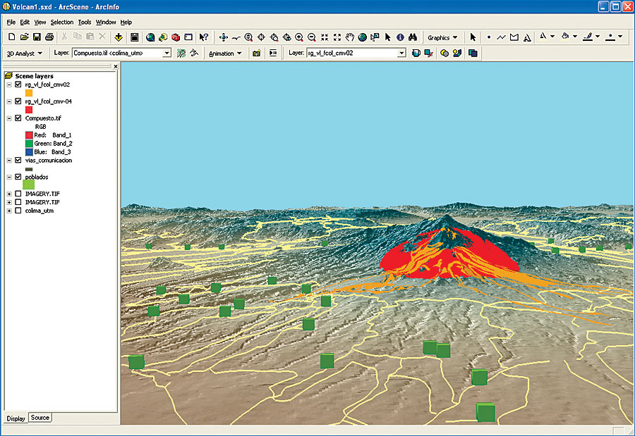
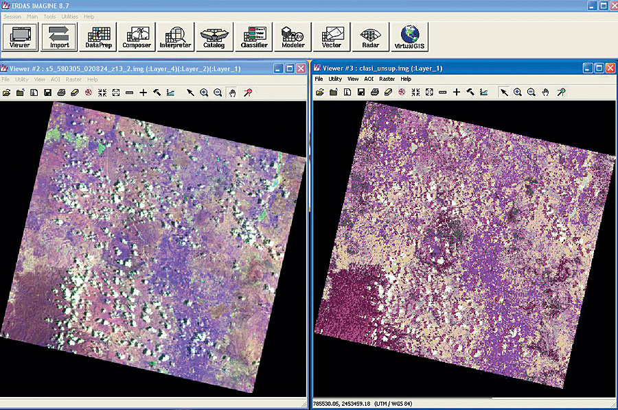
CENAPRED chose Esri's ArcGIS products and ERDAS IMAGINE software from Esri Business Partner Leica Geosystems for the project after a technical study determined that the software packages worked well together and would support nationwide geospatial risk analysis, image processing, and data dissemination. According to Oscar Zepeda, head of the National Atlas of Risks Area, National Center for Disaster Prevention, "The Mexican Atlas of Risks includes a natural and human-made risk diagnostic tool to help determine how disastrous events will affect communities, infrastructure, and the environment. We began by collecting and processing data to be used as input to our models for generating different risk scenarios, such as earthquakes, hurricanes, landslides, and hazardous material transportation." CENAPRED uses three workstations, 15 personal computers, and three servers to process and store the data and applications. Mexican government data sources and commercial satellite data from Landsat and SPOT Image are used to generate risk data. CENAPRED staff creates and processes digital elevation models (DEMs), vector data, and raster data. Using ArcInfo, a TIN layer is generated for calculations and three-dimensional displays and to create grid layers. Other interpolation methods, such as kriging, topo gridding, inverse distance weighted, or splining—depending on the terrain conditions, are utilized to generate data in raster format. Using ArcGIS Spatial Analyst and ArcGIS 3D Analyst, DEMs are generated from contour lines, GPS field data, and lidar data. CENAPRED uses ERDAS IMAGINE to process lidar data to produce more detailed DEMs in the areas that are being studied and uses the Surface and Mosaic tools when building large DEMs. ArcScan for ArcGIS is used to scan and create vector coverages from existing paper maps, such as government soil or geological maps. ArcGIS Network Analyst is used to generate the drainage network. CENAPRED's monitoring systems are continuously recording terrain data, such as variables associated with earthquakes, volcanoes, and landslides, using very accurate sensors. "This special data is used with risk evaluation modeling algorithms to generate different risk scenarios in a geographic area," states Zepeda. Using ERDAS IMAGINE, CENAPRED performs multispectral analysis on satellite images to create new data layers. According to Zepeda, "We input land-use and vegetation variables and perform several multispectral classifications until we generate the final layers for these two variables. In fire and/or flooding situations, we use supervised and unsupervised classification methods, as well as change detection, for before-and-after image comparisons." Then CENAPRED calculates risk scenarios using Map Algebra in ArcGIS Spatial Analyst. With ERDAS IMAGINE, it mosaics the derived data. Finally, maps displaying risk and vulnerability are created with the generated data overlaid on top of topographic and other vector layers.
According to Zepeda, "Production data for risk analysis and vulnerability varies depending on the natural hazard being evaluated or mapped." For the primary natural hazards that can affect Mexico, CENAPRED performs a general analysis of the hazard's causes and effects. ERDAS IMAGINE software is used to perform multispectral classification to locate areas potentially affected by floods, hurricanes, or landslides. ArcGIS is used to perform spatial and geostatistical analysis of risk by overlaying variables, such as danger and vulnerability, with different at-risk systems, such as housing, hospitals, and schools. For example, when analyzing flood hazard potential, ERDAS IMAGINE is used to calculate risk based on elevation classification maps, hypsography, slope, and/or slope classifications. The vulnerability assessment involves field research where the field team uses GPS and an ArcPad application to collect information about buildings and their physical characteristics that may be affected by a potential hazard. In general, they are classified by the type of slope on which they are built, types of construction materials used, and the vulnerability to a specific risk. The completed risk and vulnerability layers are converted to a raster format. Using the Map Algebra functions in ArcGIS Spatial Analyst, risk and vulnerability layers are combined with terrain data and drainage networks to determine which areas are likely to be affected in a disaster and quantify the potential physical and economic damage of different hazard types. "A house can be in a zone vulnerable to flooding," Zepeda explains, "but will be more or less affected depending on the physical conditions or the hazard intensity. However, the same house could be totally vulnerable in a flood situation and unfortunately there is no possible mitigation. The National Atlas of Risks project unifies the criteria for risk analysis nationwide. It is the first effort to serve national information, from a variety of sources, over the Internet using GIS for the purpose of risk analysis and mitigation." In the aftermath of Hurricane Wilma, CENAPRED is performing field research using ArcPad to collect building and infrastructure location and damage information. "This field data is loaded into the National Atlas of Risks to make information about the hurricane impact area and quantified damage reports available to civil authorities and citizens for recovery efforts and future mitigation planning," Zepeda concludes. For more information on this project, contact Ing. Oscar Zepeda, head of the National Atlas of Risks Area, National Center for Disaster Prevention (e-mail: ozr@cenapred.unam.mx, Web: www.atlasnacionalderiesgos.gob.mx). For more information on geospatial imaging solutions, contact Leica Geosystems Geospatial Imaging (toll free in the United States: 1-877-463-7327, outside the United States: 1-770-776-3400) or visit Leica Geosystems at gi.leica-geosystems.com. |