Winter 2005/2006
Winter 2005/2006 |
|||||||
|
|
|||||||
In Albuquerque, New Mexico, Shared Geographic Information Is Key to Project Success
Middle Rio Grande River Being Restored Using GIS |
|||||
|
The future looks cleaner and greener for Albuquerque, New Mexico. A legion of federal, state, and local government agencies; tribal communities; conservation groups; and nongovernment organizations, funded by the U.S. Congress and led by the U.S. Army Corps of Engineers, has embarked on a massive restoration project of the Middle Rio Grande River. The project group today guides the modern course of the Middle Rio Grande River as it bisects the city of Albuquerque, New Mexico.
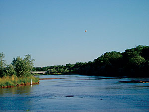
Water is at the heart of this project. For centuries, the Middle Rio Grande has been the cradle of life in New Mexico. River damming calmed destructive flooding but also narrowed and deepened the river channel, resulting in environmental loss for indigenous cottonwood stands. The bosque, defined as a small wooded area, is a natural habitat for endangered species, such as the southwestern willow flycatcher. Floods served to germinate new cottonwood stands; clear dead brush; and carve out small, shallower riverbeds. The once wide river channel was an ideal breeding ground for the silver minnow, another now endangered species. Times changed, as did the river. Population growth intensified in the 20th century—most notably in the city of Albuquerque. Houses, apartment complexes, streets, railroad tracks, freeways, bridges, and dams slowly encroached on the river bosque. The stabilized river led to closer human habitation and, subsequently, more pollution—a common story of ecological destruction. Increased human habitation brought significant structural changes to the river. The aggradation of the channel, a result of downriver damming, reduced the surrounding water table as the channel deepened and narrowed. Many of the adjoining cottonwood stands, starved of water, withered and died and were replaced by exotic plants and brush, which fueled wildfires. Albuquerque's number one natural hazard risk is fire. Modern water control measures prevent the natural brush-clearing effect of floods, which increases the risk of wildfires leaping from the bosque to adjacent residential communities. Restoring the Natural OrderThe U.S. Army Corps of Engineers, with its legions of supporting agencies and organizations, aims to restore a natural order in accord with a modern urban lifestyle; this is no easy feat, but work so far has been positive. One core project objective was to secure both interorganizational and community consensus, a cardinal reason why the U.S. Congress assigned the corps project responsibility.
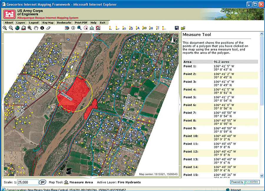
According to John Peterson, GIS developer for the bosque project and a corps employee, GIS assumed a new role as not only an analysis tool but also an information dissemination tool. Following an evaluation process, the corps teamed up with Latitude Geographics, a Victoria, Canada, company and Esri Canada Limited Business Partner that specializes in Web-based GIS, to implement a dynamic and interactive online mapping system using ArcIMS. As the project entailed constant communication among varied stakeholders, the corps needed a tool that would enable nontraditional GIS users to access a plethora of geospatial information. "The functionality of ArcIMS coupled with Latitude Geographics' Internet cartographic and technical applications and services," says Peterson, "empowered the corps to engage its stakeholders and community advocates to use the Middle Rio Grande River Bosque GIS program. The Internet-based GIS moved project information from being centrally organized to a self-service orientation." The bosque river map, accessed from the project Web site (www.bosquerevive.com), includes tools that can measure area; draw points, lines, and polygons; add text and labels; and spot coordinates. The power of the system is the ability to amend maps, save them, e-mail them to colleagues, and receive adjustments from colleagues. This process is all accomplished via the Internet and without the need for training or acquiring various site licenses. This Internet-based GIS tool promotes dynamic interaction and consensus building. Peterson says, "The scenario might be that you bat an idea around using the saved session format. After the idea stabilizes, you create a PDF that encompasses the final static decision based on a consensus." One example of information dissemination is an application created by the corps using Latitude's Geocortex Internet Mapping Framework (IMF) software. The application identifies fire hydrants within a radius based on a fire location. By adding layers to the Internet map, firefighter dispatchers quickly relay information to field units to determine the nearest hydrants and closest access points to a fire. Coupled with analysis conducted by the Native Communities Development Corporation, firefighters may also locate nearby swimming pools as an extra water supply. The Internet map hosts a number of key layers that the community may access and freely use. A key to reaching an ecological balance is to achieve community buy-in for restoration efforts, not only in terms of greater environmental awareness but also to support development efforts. "All ends of the economic bracket are positively impacted by all this work being done," Peterson explains. "You also have more wildlife habitat created with more recreation areas." The Internet map assists in communicating these efforts. Latitude's Geocortex Statistics product allows the corps to track community site hit rates and usage patterns. Popularity for the site is growing. One powerful function is the ability to map the areas that are most commonly visited on the Web site. A red to green color schematic overlaid on top of the map indicates areas of high visit activity (red). This not only informs the corps where additional maps or information may be added but also indicates which spatial areas are most interesting to community visitors. "Overall, there is enthusiasm up and down the river as you affect whole neighborhoods through these revitalization efforts," Peterson explains. For the bosque river project, information is the glue that binds the multifaceted and multitalented project group. The information dissemination tool is GIS software, which is helping restore ecological harmony to the Middle Rio Grande bosque. In 2004, the Corps of Engineers won the prestigious American Association of Landscape Architects' Honor Award in Analysis and Planning for the Middle Rio Grande Bosque Restoration Project. For more information on the Middle Rio Grande River Bosque Project, visit the project Web site (www.bosquerevive.com) or Latitude Geographics (www.latitudegeo.com). |