Winter 2005/2006
Winter 2005/2006 |
|||||||
|
|
|||||||
10,000 Technicians Use Digital Toolbox to Manage Daily Routes from the Field
Sears Holdings Corporation Deploys GIS Navigation and Mapping System |
|||||||
|
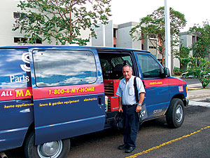
Sears Holdings Corporation (SHC) is the United States' third largest broadline retailer, with The company is also a business GIS pioneer, having deployed GIS since the 1990s and achieving millions in cost savings while improving customer service. The company's original foray into GIS more than a decade ago began with the idea of improving its home delivery routing; reducing the delivery time window SHC provides; and, ultimately, building on its century-old promise of "Satisfaction Guaranteed or Your Money Back." This resulted in the implementation of the landmark application known as the Sears Enhanced Home Delivery System. In the process, the company developed an extensive GIS database and substantial GIS expertise. This led to other GIS applications, including a warehouse optimization application and a service area planning application. While GIS improved home delivery and other business functions, there were still further opportunities for improvement. SHC has now achieved its next GIS success, using a wireless field solution. The field GIS provides 10,000 SHC home services technicians with an in-vehicle, navigation and mapping system that leverages on-board GPS, satellite and terrestrial data communication, verbalized directions, and ruggedized laptop technology that provides a touch screen interface.
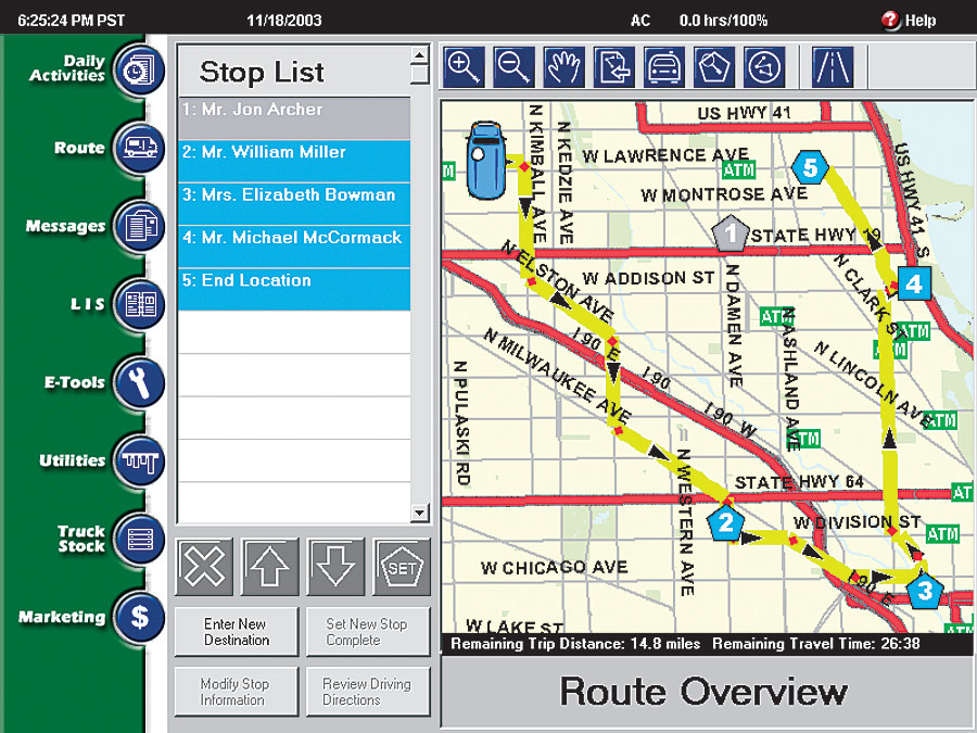
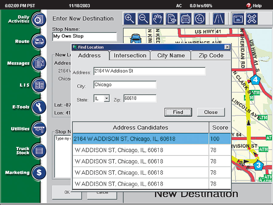
"Sears had the vision to deploy a digital toolbox with a wireless workforce management system, library information system, mapping, and navigation," says Daniel Bowman, Sears Smart Toolbox (SST) Program manager. "We wanted to provide this technology to our field service technicians to enhance their ability to serve customers and repair merchandise. Technicians were still using paper map books and manual data tracking. If these paper-based methods could be replaced with digital information tools using a simple yet effective interface, technicians could work more efficiently and have greater flexibility in their daily activities." With the idea of extending technology and GIS benefits to the field, SHC again approached Esri Professional Services—which had been instrumental in the development of the Sears Enhanced Home Delivery System—to create a strategy for carrying out the new vision of a field GIS. The Sears Smart Toolbox ApplicationEsri staff quickly began developing the GIS-enabled mapping and navigation system. After working extensively with SHC staff for user input and needs assessment, Esri staff outlined several application goals. This included a simple touch screen interface, an easy-to-use navigation display and voice guidance, automatic rerouting when the vehicle veered off course, and the ability to accept stop changes wirelessly and on the fly. With the application goals in place, Esri Professional Services spent the next six months building the system; this included providing system and database design, application development, performance testing and enhancement, documentation, and training. The Sears Smart Toolbox application launches automatically when the ruggedized Itronix laptop, also known as the GoBook, is powered on. The entire suite of technologies runs within an Internet Explorer browser. When the vehicle is stationary, users have the option to view their daily routes, view current progress along the route, geocode new stops, and make some modifications to routes in the local database. When the vehicle begins to move, the mapping component switches into navigation mode and takes over the entire screen of the GoBook. In navigation mode, the application displays the vehicle's current position on the route and turn-by-turn navigation symbols and gives verbal directions as the vehicle approaches turns. In navigation mode, the technician is prevented from interacting with the application (for obvious safety reasons), and must stop the vehicle to do so.
Esri used ArcObjects software components to create the customized wireless field application. ArcObjects provided an open, standards-based environment that would easily integrate with the existing GIS architecture and the overall IT environment. It supplies the geographic intelligence, such as map visualization, geocoding, and routing. The ArcObjects functionality was extended to provide the required navigation and tracking capabilities. The Microsoft Speech API 5.1 text-to-speech engine provides the audio driving instructions. The application interfaces with the work order management application developed by SHC and the onboard GPS. On top of the vehicle, the Mobile Base Station (MBS) communications device, manufactured by Wireless Matrix in Reston, Virginia, wirelessly communicates data between the SHC Command Center, which houses the GIS server, and the work order management system. This is done via cell tower or satellite. Every four seconds, a GPS device collects point information that is used by the GIS for tracking vehicle movement and routing. This allows the wireless laptop to download the day's route, individual stops, and related work order information dynamically throughout the day. If a new route needs to be provided to technicians on a same-day basis, the information can be quickly delivered to the SST, and the overall route can be dynamically updated. In addition, a current stop can be uploaded and sent back to the server for reassignment. A nationwide Tele Atlas/TomTom dataset, slightly more than 1 GB in size, is used in each vehicle. Street data is updated every three months. Esri's Smart Data Compression (SDC) data format provides the storage capabilities for such large datasets. This eliminates the logistical hurdle of deploying different geographic datasets to different regions of the country. More Stops, Better Efficiency, Greater Customer ServiceThe mapping and navigation functionality allows technicians to get to their stops more efficiently, saving time and money and providing greater value to SHC customers. This is especially vital for SHC today, since service areas are expanding in size as technician skills become more specialized. With more specialized service professionals working in a wider geographic range, it is imperative to enable these workers with optimized field navigation, since technicians may not be familiar with the area in which they are working.
By providing the optimal route from stop to stop and by guiding technicians visually and/or by voice to the next stop, SST reduces miles and time traveled between each stop. In addition, it dramatically reduces the possibility that a technician will get lost. The new system replaces the need to purchase paper map books and the need for a technician to look up a customer stop prior to departure. SST gives field crews the next navigation instruction as soon as they finish a work order and begin moving to the next work order. Field crews are also working with more up-to-date street information, with the Tele Atlas/TomTom street data updated quarterly. In addition, nationwide ATM data on each GoBook allows SHC technicians to find the closest ATM to deposit cash they may have collected. Similar data on parts suppliers is also available; workers can easily change a route to add a supply stop. "Sears saw the need to enable its technicians with technology that allows them to do their jobs with better quality; improve customer satisfaction; and, ultimately, be more efficient—which reduces operating costs," says Esri project manager David Lewis. "The mapping component of the Sears Smart Toolbox allows technicians to optimize their routes and schedule their day more efficiently." For more information, contact Daniel Bowman, Sears Smart Toolbox Program manager (tel.: 847-286-2500), or David Lewis, Esri project manager (tel.: 909-793-2853, ext. 1-2835; e-mail: dlewis@esri.com). |
 approximately $55 billion in annual revenues and approximately 3,800 full-line and specialty retail stores in the United States and Canada. SHC is the leading home appliance retailer as well as a leader in tools, lawn and garden, home electronics, and automotive repair and maintenance. It also delivers more than five million products to homes annually and is the largest product repair service provider, with 14 million service calls made annually.