Winter 2005/2006
Winter 2005/2006 |
|||||||
|
|
|||||||
Southern Company's Enterprise GIS Streamlines Communication Between Its Five Electric Utilities |
||||||||||||||||||||||||||||||||||||||||||||||||||||||||||||||||||
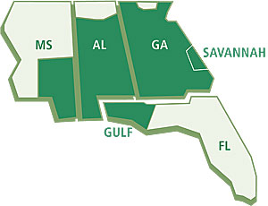
In four states of the southeastern United States, Southern Company has an enterprise GIS vision and a plan to bring that vision to reality. The enterprise approach to GIS enables Southern Company's five operating electric companies—Alabama Power, Georgia Power, Gulf Power, Mississippi Power, and Savannah Electric—to improve customer service, cost containment, and profitability. Georgia Power, the largest of the five electric utilities, serves two million customers located in 153 of Georgia's 159 counties. Savannah Electric serves more than 300,000 people in a five-county region of Georgia. Alabama Power, the second largest subsidiary, serves 1.3 million homes, businesses, and industries in the southern two-thirds of Alabama. Gulf Power serves northwest Florida, with approximately 400,000 retail customers in 71 towns and communities. Mississippi Power provides electricity to approximately 200,000 customers in 23 counties in southeast Mississippi. Each of these five utilities historically operated and maintained an independent GIS, with limited sharing of infrastructure and support. This resulted in duplication of efforts in maintaining, administering, and supporting GIS across the various business units (e.g., distribution, transmission, land, economic development, marketing). Substantial cost savings and knowledge-sharing opportunities had historically been missed, which directly impacted Southern Company's bottom line. Recognizing the need to leverage common business requirements, centralize information technology architecture, and optimize GIS investments to meet the needs of the whole organization, Southern Company established an enterprise GIS (E-GIS) project in 2003.
"Southern Company invests a substantial amount of money in the continuing operation of existing GIS environments at its various operating companies," says David Breland, Southern Company's current E-GIS business analyst and GIS lead. "The aim of the E-GIS project has been to look at consolidating this investment to support a common architecture, structure, and pool operating costs, and better provide value to each operating company while improving the opportunities for further development and support of the business in the future." Southern Company formed a GIS Core Strategy team, including management representatives from all the operating companies, which reported directly to the Southern Company IT Steering Committee. During 2003, the team developed a collaborative strategic E-GIS vision across companies and business units and finalized an enterprise site license for Esri GIS software (see "Southern Company Mainstreams GIS Across Organizations"). Southern Company then enlisted the services of Esri Business Partner Enspiria Solutions, Inc., a consulting and systems integration firm based in Denver, Colorado, to define the most effective and efficient approach for implementing a company-wide GIS enterprise environment based on Enspiria's extensive experience with utility GIS implementations. Working closely with Southern Company's GIS Core Strategy team, Enspiria developed an E-GIS plan for the company, including
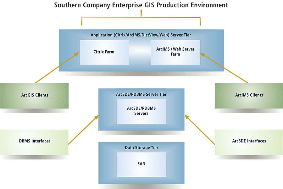
Aaron Patterson, Enspiria's E-GIS project manager, notes, "This project is a great example of a utility taking the necessary steps to plan its architecture and application deployments around real business needs and goals to ensure that maximum benefits are achieved." Southern Company's E-GIS solution consists of an ArcGIS platform based on ArcSDE with ArcObjects in addition to Esri Business Partner Miner & Miner's ArcFM toolset. The architecture is a consolidated server environment using ArcGIS software—ArcInfo, ArcView, ArcIMS, and ArcSDE—as well as ArcFM. E-GIS will be the central database for distribution, transmission, and land records across the enterprise. It also provides consistent, high-quality data to other systems. For example, it feeds data to the outage management systems in place at the operating companies to ensure optimum response to incidents, such as the recent hurricanes. And the ArcGIS platform serves as an enabling technology for addressing future Southern Company business needs. A key planning consideration was the viability and timing of operating company participation in the E-GIS rollout, given that each company is at a different stage of its GIS program and operates within unique business and regulatory environments. Alabama Power implemented a production ArcGIS system in 2004, providing a model site for E-GIS. Gulf Power, Mississippi Power, and Savannah Electric all expect to have migrated from their legacy systems to a production E-GIS environment during 2006. Georgia Power Company (GPC) contracted with Enspiria to perform a detailed analysis of the costs and benefits to migrate from its existing AutoCAD-based GIS to ArcGIS. GPC asked Enspiria to define viable migration and implementation options, along with the costs and risks of each option, so that GPC could make the business decisions on how to best move forward. The result was the approval of the GPC GIS Implementation Project in June 2005.
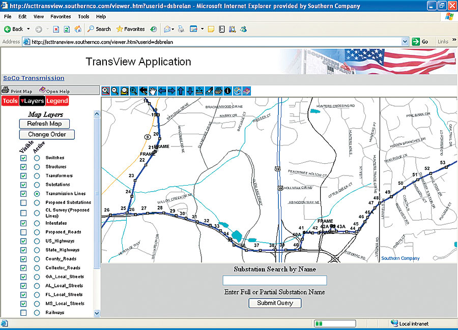
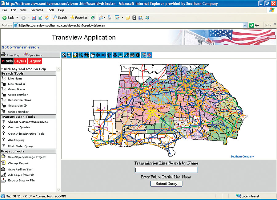
Mary Adams, distribution support specialist at Georgia Power Company, explains, "We evaluated E-GIS from the standpoint of our current business needs and as the spatial foundation for future applications, including mobile, work management, and scheduling." The Southern Company GIS Core Strategy team presented its recommendations and associated implementation plan in early 2005. "The E-GIS plan has been approved by Southern Company executive management for implementation from late 2005 through 2007," says Danny Childs, Southern Company GIS business analyst. "We have made a commitment to increased efficiency and associated cost savings through an integrated business and GIS technology environment." Many enterprise applications leveraging Esri technology are already under way and are paying dividends, including Southern Company's TransView application, which provides systemwide query and work design for all five operating companies. For more information, contact David S. Breland, E-GIS business analyst, Southern Company Services (tel.: 912-944-1359, e-mail: dsbrelan@southernco.com), or Mehrdod Mohseni, vice president, Marketing and Business Development, Enspiria Solutions, Inc. (tel.: 303-521-5395, e-mail: mmohseni@enspiria.com, Web: www.enspiria.com). GIS Software in Use at Southern's Operating Companies
|
||||||||||||||||||||||||||||||||||||||||||||||||||||||||||||||||||