Winter 2005/2006
Winter 2005/2006 |
|||||||
|
|
|||||||
Extensive Spatial Infrastructure Uses Local Data and ETL Technology and Processes
USGS, NGA, and DHS Collaborate to Build "GIS for the Gulf" |
|||
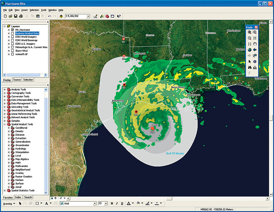
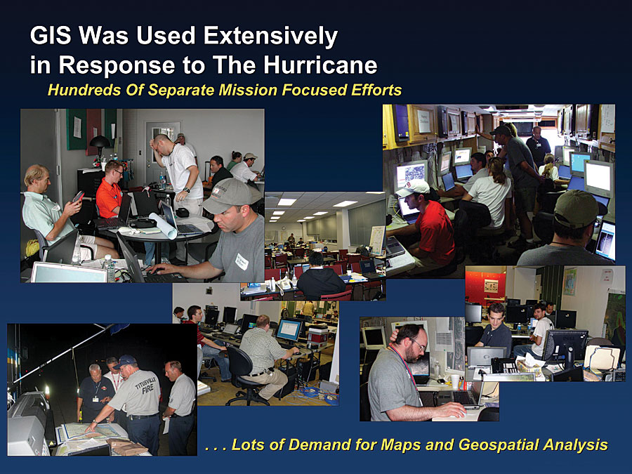
The United States Geological Survey (USGS), the National Geospatial-Intelligence Agency (NGA), and the United States Department of Homeland Security (DHS) have implemented a GIS database for areas affected by hurricanes Rita and Katrina, extending large volumes of data to organizations responding to the disasters. GIS for the Gulf (GFG) brought GIS data from many different systems together into one repository built upon the GIS for the Nation data model developed by USGS. Its purpose was to meet the immediate hurricane response needs, to provide a resource for long-term recovery and reconstruction efforts, and to assist in preparedness for future hurricane seasons. The National Geospatial Program Office (NGPO) of the USGS intends for the GFG to serve as a technical and partnership blueprint for successfully carrying out the GIS for the Nation vision across the country. That vision is centered on collaborative partnerships with local, state, and other federal agency GIS organizations to facilitate data stewardship and sharing. Partnerships are designed to link local organizations into a national approach using tools such as the Geospatial One-Stop and the National Map. "This was an opportunity to combine the talents of USGS leadership, in partnership with DHS, Esri, NGA, and a number of local and state organizations, to think about a different approach for building GIS for the Gulf," says Hank Garie, chief, Geographic Information and Analysis, National Geospatial Program Office, USGS. "This approach entails developing a data model and integrating data into that model. GIS for the Gulf is the first geographic area where we built upon things such as Project Homeland and other pilots, to serve an emergency response need." "We're working with several government agencies to carry out this vision of connecting individual GIS systems to support a variety of needs," says Jack Dangermond, president, Esri. "This work takes advantage of the National Spatial Data Infrastructure (NSDI), the National Map, Geospatial One-Stop (GOS), and other enterprise models to foster a new level of collaboration, sharing, and integration. It will spur the development of larger, integrated applications and data access that cut across organizations." As part of this effort, DHS, Esri, NGA, and USGS are leveraging and enhancing the existing GOS portal to provide access to the GIS for the Gulf database via simple and easy-to-use applications within the current GOS portal application framework. In addition, these organizations are working together to integrate the GIS for the Nation database that was implemented for GIS for the Gulf within the NGA Palanterra system and the DHS Infrastructure Critical Asset Viewer (iCAV) application. The NGA Palanterra system is being developed and supported under Project Homeland. Project Homeland is also providing technical support to the DHS iCAV Project, which is using the NGA Palanterra application. Building an All-Purpose Data-Sharing ModelLessons learned from the 2004 tsunami and other recent natural and human-caused disasters have forced U.S. federal, state, and local agencies to examine how they can facilitate easier and more effective collaboration between organizations, particularly for leveraging independent local datasets that could be deployed immediately when needed. Early in February 2005, USGS first worked with local government agencies and other organizations to investigate building an all-purpose data-sharing information model that would work for local, state, regional, and national needs. This built upon previous GOS and Federal Geographic Data Committee data standards work and resulted in the first draft GIS for the Nation design and specifications, which was presented in August 2005 at the Esri International User Conference in San Diego, California. "We had already worked with a number of partners and had many of the provisions in place for a GIS for the Nation model prior to the hurricane disasters," says Robert Pierce, USGS. "Then Hurricane Katrina came along. In the immediate aftermath of Hurricane Katrina, leaders from DHS, the Federal Emergency Management Agency (FEMA), NGA, and USGS began work on GIS for the Gulf, which includes the states of Alabama, Louisiana, Mississippi, and Texas. They worked to connect many different GIS systems and datasets into a greater whole. This required multiple-agency participation at all levels of government and private industry. These organizations began to share, import, integrate, and synchronize datasets into operational databases for the Emergency Operations Centers. The result was a comprehensive database based on a standardized, multiscale data model, providing a consistent view of data across jurisdictional boundaries. Integrated datasets were assembled and began to ship within just a few weeks. "This system has the potential to save lives and property during future events," says Russ Johnson, emergency response manager for Esri. "It will help emergency professionals in their very important work by saving time, resources, and manpower; the infrastructure will already be in place and accessible to those who need it prior to, during, and after an event. It supports disaster management, but it can also support many areas of daily business at all scales of government. Agriculture, economic development, health, homeland security, public safety, transportation, and other government units can all benefit." GIS for the Gulf TodayToday, GIS for the Gulf benefits from the many weeks of effort immediately following the hurricanes and the continued improvement and extension of the system. Based on the USGS data model, GIS for the Gulf data themes include emergency operations, structures/critical infrastructure, government units, utilities, addresses, transportation, cadastral, hydrography, environmental, land use/land cover, basemap, elevation, geodetic control, and imagery. Data providers include dozens of local, county, state, and federal agencies in and around the gulf region. There are several ways to access GIS for the Gulf via the Geospatial One-Stop portal. This includes a GIS for the Gulf viewer for responders, data download capabilities, and online data viewing, as well as custom Web services, such as "check my house," allowing the public to locate their homes and view current aerial photos of their neighborhoods. In addition, GIS for the Gulf data was delivered to FEMA joint field offices as well as other government offices. "What we ended up with was a database of the affected area consisting of roughly 60 data layers, including detailed parcel information and aerial imagery, combined with a suite of applications that allows data to be viewed, analyzed, and manipulated through GOS," says Garie. "In addition, for the first time, USGS is able to deliver updated topographic maps on demand of the affected area. Users also have the ability to download this information all in a secure environment that is password protected." Data collection was prioritized by geography and content, with focus on regional datasets, such as transportation and administrative boundaries from the four states, and large local datasets, such as parcels, structures, and aerial imagery, from the coastal counties. Teams focused on finding data and performing extraction, transformation, and loading (ETL) processes and inputting data into the production server. This includes geographic features; related attribute information; and descriptive metadata, which incorporates data history. In addition to individual systems, the extended regional GIS network is available for connecting systems at various levels of government. Standardized data content guidelines ensure consistent information for any user. Where GIS for the Gulf Goes From HereWhile GIS and existing shared data models proved essential, GIS leaders recognized several areas where improvements could be made. The value of additional pre-event preparedness, particularly a fully integrated, deployable GIS infrastructure, would improve many different emergency response capabilities and processes for future events. It would also provide enormous value for long-term recovery. "We need to continue to reach out to local organizations and coordinate with statewide GIS leaders to ensure partnerships and data sharing agreements are in place. The time to develop collaborative relationships is not during an emergency, but well before," Garie stresses. The majority of data collection takes place at the local and state levels and moves up into federated systems. Information is captured by various participating agencies and is shared and exchanged as needed. The organizational framework promotes data sharing and data development. Based on needs requirements, a set of commonly used data, analyses, and other applications are already in place and are ready when an event occurs. "GIS for the Gulf was a success because we were able to get it out of the door and into the hands of first responders shortly after the hurricanes hit," says Pierce. "Now it is an ongoing project that will evolve and improve over time. It will provide a much better, easier, and more cost-effective solution for future events." GIS for the Gulf provides knowledge exchange prior to an event regarding what data exists, where it is located, who owns it, how accessible it is, and more. It provides specific security levels for various datasets, ensuring only the right people view the right data. It also fosters organizations working together, sharing information, and effective operation using a common information palette. There were several factors that contributed to the initial success of GIS for the Gulf and its future development. USGS staff was familiar with the data model and performed most of the ETL functions. In addition, much of the basemap (framework) data for the Gulf area was already available through the National Map. Strong existing relationships among DHS, FEMA, NGA, USGS, Esri, and others enabled the team to collect more data. Many counties had GIS systems already in place and ready to be integrated. State and federal GIS clearinghouses were able to provide an enormous amount of data, such as National Hydrography Dataset and census. In addition, the USGS imagery services were available throughout the event. "The future goal is to include the state of Florida as part of GIS for the Gulf and to extend the database to serve as a foundation for long-term recovery efforts, such as planning new communities, new schools, and more," says Garie. "The goal is to also include new digital datasets that are built and added to the integrated base. We want to share what we've done so that others can benefit from it. Without the help of our partners down in that region, as well as other state and federal agencies, we would not have had the resources to pull together the integrated data model." For more information, contact Hank Garie, chief, Geographic Information and Analysis, National Geospatial Program Office, USGS (e-mail: hgarie@usgs.gov), or Pete Bottenberg, Esri (e-mail: pbottenberg@esri.com). |