Winter 2005/2006
Winter 2005/2006 |
|||||||
|
|
|||||||
Employees and Citizens Both Benefit from Efficient Data Serving
West Springfield, Massachusetts, Builds Information Portals with GIS |
|||
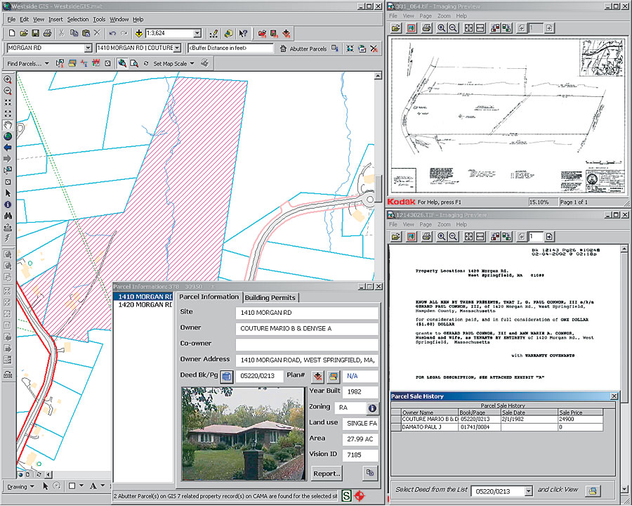
The town of West Springfield is a small community located in western Massachusetts. Once a quiet agrarian community, it has seen major commercial development over the last few decades. Only 17 square miles in size with a population of 28,000, the town has a mixture of land uses—mostly residential with commercial development along the highways and in downtown regions. Like any other town, demand for its municipal services keeps growing as businesses expand and the population grows. Realizing the importance of digital and interactive mapping for tax assessment, public works, planning, emergency management, etc., the town developed a GIS in 1998 using aerial flyovers, field surveys, deeds research, etc. Since then, GIS has been playing an important role in meeting the ever-growing demand on municipal services. Case in PointFor example, in many instances, municipal and property data, though available in digital format, has nonetheless traditionally been spread among and maintained by multiple departments. This made it necessary to visit or call each department or use multiple applications to gather required data, which took time. Therefore, the answers to questions such as Who is the owner of a property? How is the property defined in the deed? Does a lot have any special permits? and Where are the closest fire hydrants? required town employees to "run the gauntlet" to find answers. To solve this problem and bring information to the municipal employees quickly and effectively, an in-house GIS project was initiated so that staff members could spend more time on decision making and less time on searching. Since GIS can serve both spatial and nonspatial data, it was chosen as the medium to tie all databases and documents together. Spatial data is stored in Esri's personal geodatabase to take advantage of object-oriented functionalities and flexible topology. ArcGIS Desktop (ArcView, ArcEditor, ArcInfo) applications were chosen as the development platform for easier customization and seamless integration with other databases, such as Oracle, MySQL, and Microsoft Access. The ArcGIS Desktop products have been customized to provide options such as searching for parcels, closest hydrants, plans, streets, and engineering drawings; viewing sale deeds and drawings; report generation; and creating mail-merged letters for notification. These applications are provided by one platform called the West Springfield Municipal Information System (WSMIS). WSMIS consists of three major components:
The most frequently used application is a customized ArcGIS Desktop ArcMap application with ArcObjects, ActiveX Data Objects, and Visual Basic for Applications codes for seamless integration with other databases. The town's GIS is customized to retrieve updated information, such as owner name and sales history, for any parcel directly from the tax database. It removes the need to create a temporary table to be joined to the parcel layer. Its support for one-to-many and many-to-many relationships solves, for example, condominium issues in which one parcel polygon is linked with many condominium units. In the customized application, users can search and view sale deeds or lot plans, receive them from the Registry of Deeds Office in digital format, and overlay parcels on lot plans instantly. Information Improves EfficiencyEdward D. O'Brien, principal assessor, says, "Through the use of WSMIS, we have enhanced our ability to record real estate deeds from the Registry of Deeds and translate that data into an effective sales recording/valuation system. Assessors always had the data before, but it was not easily retrievable. WSMIS helps not only to retrieve it easily and efficiently but also conveys it to other departments." Knowing whether a parcel has any special permit or variance changes the planning process and is very important for the town planner. Realizing that, all special permits and variances are converted to digital format and stored in a free and open source database called MySQL. Parcel IDs are used to retrieve permits quickly from that database. The town's building inspectors also use WSMIS to find any building, gas, or plumbing permits issued to a parcel, in addition to other information, such as zoning regulations, photos, year building was built, and land use. To explain how important WSMIS is, building inspector Tom Lagodich says, "We turn on WSMIS as the first order of the day, as we deal with hundreds of requests for information. WSMIS has saved this department hours and hours of work by having information at our fingertips. In the past, we would have to go to numerous departments to gather information. The savings in man-hours—not only for the department but also for businesses, developers, builders, and residents of the town that we serve—are immeasurable. We often wonder how we got by before WSMIS." The Department of Public Works, one of the biggest users of the town GIS, recently scanned all plans, field cards, water tie cards, and other engineering drawings and is developing a document-searching application. ArcGIS Desktop has been modified to search and view water tie cards by address and zoom to the parcel, which saves the department a considerable amount of time that would otherwise be spent sorting through piles of cards. Street data with measurements is also linked with a pavement management system for the dynamic display of pavement condition. The West Springfield Fire Department has been using GIS for emergency dispatches for several years. Applied Geographics, Inc., an Esri Business Partner, developed an E911 Incident Map for the town using MapObjects, which is connected to the phone line. It automatically zooms to the incident location when a 911 call comes in and shows locations and distances to nearest fire hydrants. A Microsoft Access-based Fire Inspection Database, with embedded Esri MapControl and a simple interface, lets fire inspectors—without any GIS training or experience—easily add locations of shutoffs, hazardous materials, exit doors, etc., which was never possible before. It exports data to the E911 Incident Map directly so that firefighters can view those locations on the computer instantly when a call comes in. Fire lieutenant Steve Link says, "Utilizing the mapping system enables the firefighters to quickly analyze the area before being dispatched. Being able to preview the location of these features on laptops, we can plan ahead how to approach the situation even while we are on the road." Serving Data to the CommunityThe town always wants to serve the community better. Disseminating public information over the Web means residents and businesses can get required information at their convenience. Two ArcIMS Web sites were developed to provide public access to tax- and survey-related information. To make the system less expensive yet more stable and robust, ArcIMS runs on an open source and free Apache Web server on Linux. Java, Java Database Connectivity (JDBC), and JavaServer Pages (JSP) technology are used for retrieving property information directly from an Oracle database. In addition to public use, ArcIMS sites can also be used by anyone in the town hall, saving the town money on licenses. Kathy O'Brien-Moore, collector-treasurer, says, "Tax collections have been much less difficult as access to the deed is immediate. It has saved on trips to the Assessor's Office and the Registry of Deeds." For more information, contact Mohammed A. Hoque, GIS coordinator, town of West Springfield (tel.: 413-263-3070, e-mail: thoque@west-springfield.ma.us, Web: gis.west-springfield.ma.us). |