Winter 2008/2009
Winter 2008/2009 |
|||||||
|
|
|||||||
Provides GIS and CAD Interoperability
Esri Releases New Version of ArcGIS for AutoCAD |
|||
Highlights
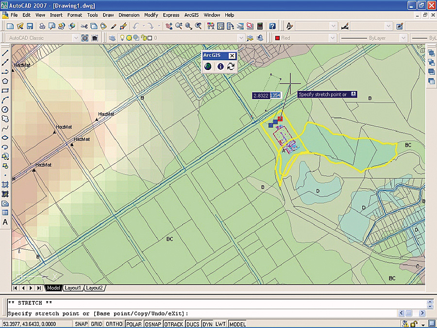
For existing AutoCAD users, ArcGIS for AutoCAD is a simple way to access GIS information and have the results of GIS analysis delivered via ArcGIS Server map services. Through this free, downloadable tool, enterprise GIS information from many public and private sites that publish map service data over the Web with ArcGIS Server can be included in AutoCAD. This is done without transformation of CAD drawings or conversion of GIS data. With the release of ArcGIS for AutoCAD (Build 200) and due to enhancements provided in ArcGIS 9.3, such as improved map service performance, GIS and CAD interoperability can be attained with ease. Interoperability with ArcGIS: The Complete Enterprise GIS
As an ArcGIS Server client application, ArcGIS for AutoCAD has the ability to access map content that was authored with ArcGIS Desktop and served or published as a map service by ArcGIS Server. Furthermore, anyone with a Web browser and access to ArcGIS Server map services, AutoCAD 2007 or higher, and ArcGIS for AutoCAD can pull existing GIS data into their AutoCAD work products. ArcGIS Server map services are automatically projected in AutoCAD based on the coordinate system definition stored in the CAD drawing. This is important to interoperability, because no conversion within the drawing or the CAD data is required. The cartographic and computing power of ArcGIS is provided to the AutoCAD user without the overhead of data management or the need for special data connections, symbology mapping, conversion, or translation. In addition, all vector, raster, and imagery formats that ArcGIS Server supports can be viewed in the AutoCAD environment as part of the map service. With ArcGIS for AutoCAD (Build 200), support is extended to include secure servers and ArcGIS Server 9.3 cached map services. As a result, AutoCAD users can now truly utilize the full capabilities of ArcGIS Online Services, which offer free map services for existing ArcGIS users, as well as subscription services for non-ArcGIS users or for those seeking premium content. Quick access to world imagery, street map data, topographic data, and a growing number of other map services, all within the AutoCAD drafting environment, just became easier. File-Based InteroperabilityThere is a well-defined need to share GIS data with contractors, engineering departments, or other groups within an organization that use AutoCAD. However, in the past, it has been difficult communicating this information between the GIS professional and the CAD user due to inconsistencies in file types. ArcGIS for AutoCAD (Build 200) implements a trusted data encoding strategy to give GIS structure to AutoCAD files as an enhancement to file-based interoperability when working with AutoCAD entities. This encoding strategy developed by Esri, called Mapping Specification for Drawings (MSD), allows users to create, manipulate, and define how CAD data (e.g., the coordinate system, feature class filtering criteria, feature class attribute schema, and feature attributes on entities) is organized and attributed as GIS content. This data encoding technique is based completely on AutoCAD entities within an AutoCAD file, but when used with ArcGIS for AutoCAD or ArcGIS, the data is treated like a native GIS feature dataset. The additional GIS information specified in MSD does not change the behavior of the objects yet adds impressive added functionality. Because they remain as standard AutoCAD entities, the objects can still be utilized and shared by anyone who uses standard AutoCAD files. MSD allows both CAD and GIS groups to work together to organize GIS content according to their existing CAD standards. The end result is AutoCAD files that can be used directly as GIS content in MSD-supported applications, such as ArcGIS, ArcGIS for AutoCAD, or custom AutoCAD applications that have implemented the data encoding techniques. ArcGIS for AutoCAD offers users simple GIS and CAD interoperability with access to enterprise GIS data in the AutoCAD environment and a means to prepare the data for CAD-based design applications in a GIS-ready format. These two new forms of interoperability increase the efficiency of information sharing between both types of users without disrupting individual workflows. More InformationArcGIS for AutoCAD is a free download that requires AutoCAD 2007, 2008, or 2009, as well as access to ArcGIS 9.2 or 9.3 map services. To download this application or to learn more, visit www.esri.com/autocadapp. |