Winter 2008/2009
Winter 2008/2009 |
|||||||
|
|
|||||||
Ghana Project Leverages GIS-Based Title Registration and Microfinance to Alleviate Poverty—Part 2
Geospatial Technology Drives Adjudication |
|||||||||
|
By Peter Rabley, International Land Systems, Inc., and Craig DeRoy, Corporate Initiatives Development Group Highlights
This article is part two of a multipart series. Read Part 1 of this series. Read Part 3 of this series.
In the Fall 2008 issue of ArcNews, the first article in this series introduced a land titling project now under way in the African nation of Ghana. With support from the Clinton Global Initiative (CGI), the project sought to demonstrate how formalization of landownership helps poor people take the first crucial steps out of poverty. One of the key advantages of holding a land title is that it enables the owners to leverage their properties to receive microfinance loans that can assist them in making positive, and often dramatic, changes in their lives, such as starting or growing a small business. Sponsored within CGI by Corporate Initiatives Development Group of California, the project moved into its pilot phase in March 2008. The objective was to develop a land titling process involving the collection of property ownership information, creation of land legal descriptions, and surveys of the properties. The pilot targeted private schools in Ashaiman, one of the poorest sections of Accra, the capital city. Ashaiman is a maze of shacks and shanties, home to approximately 400,000 people, where land titling was little more than a dream. Private schools in Ashaiman were selected for the pilot because one of the project participants, Opportunity International of California, was introducing a microlending program for schools there. Operation of private schools is a growing business in Ghana, and owners are actively seeking small loans to expand their facilities to accommodate additional students. These schools demonstrate the mutually beneficial link that can be made between formalized land registration, microfinance, and poverty alleviation. Building the BasemapInternational Land Systems, Inc. (ILS), a project participant and Esri Business Partner based in Silver Spring, Maryland, spearheaded the pilot program. It faced the difficult task of developing a land adjudication process from scratch in a place where no titling had been done and where cadastral mapping had never been attempted. The stated goal of the pilot was for ILS to deliver this land titling capability in the form of a fully functional and scalable GIS-based land recording and registration system that could ultimately be used by the Ghana government to award official titles.
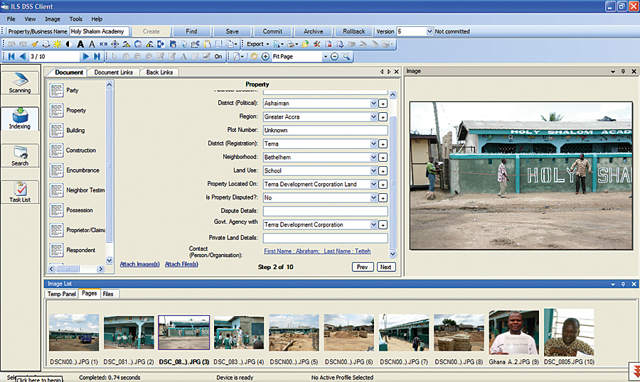
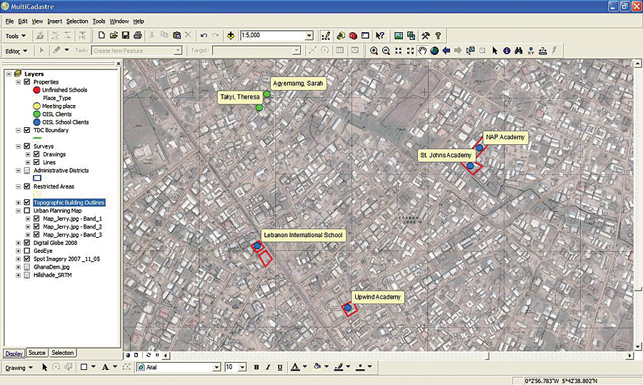
As a provider of international land registration solutions, ILS recognized the immediate need for an accurate parcel cadastre to serve as the foundation to which all landownership information would be linked in a digital environment. To build this foundation, ILS used Multi-Cadastre, an enterprise cadastral management system that it had created with ArcGIS geospatial tools under an OEM agreement with Esri. This commercial off-the-shelf product was designed to manage cadastral data and parcel fabric datasets in support of survey, tax, legal, and other applications. MultiCadastre includes a variety of tools to perform tasks such as data collection, mapping, geoprocessing, and raster catalog creation. It also manages digital text, photographic, video, and geospatial data file formats. In preparation for the pilot, ILS personnel collected as much spatial data as possible for Ashaiman. Through the GeoEye Foundation, GeoEye donated a one-meter-resolution color satellite image of the area. And after searching official archives, the Ghana Ministry of Lands, Forestry and Mines provided a high-quality topographic map created from aerial photography flown in 2003. The team tapped into ArcWeb Services through the ILS MultiCadastre system to access 3D models of the entire country and additional satellite images and data of Accra. "These data layers serve as the basemap for our land registry and parcel cadastre," says Frank Pichel, project coordinator of ILS. "In addition to providing contextual information relating to the locations of streets and buildings, the maps reveal the boundaries of floodplains, which could factor into the land titling process." For the Ghana pilot, the MultiCadastre system is using Microsoft SQL Server Express as the database that holds digital documents, photos, videos, and spatial datasets. The Pilot BeginsILS set up the MultiCadastre system in the Accra offices of SAMBUS Company Ltd., Esri's distributor in Ghana, and began training local loan officers from Opportunity International to collect the landownership and legal description of properties. This information would be needed to award each participating school a paralegal title for use in securing private loans. The term paralegal title is used to indicate that the titling process has been initiated for acceptance by the private sector to jump-start microfinance lending. The entire titling system will be turned over to the Ministry of Lands, which is the only government entity allowed to generate official land titles.
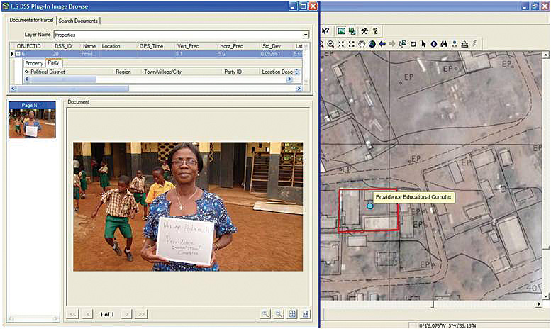
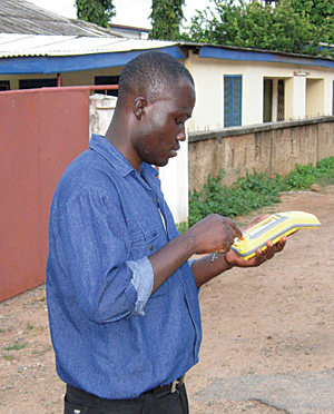
With 51 private schools in the pilot area, the adjudication process evolved quickly as the loan officers became comfortable with the methodology. Early on, they used a printed list of questions when interviewing the school owners. These questions were designed to gather the details needed to establish legal ownership of the property. In some cases, neighbors were also interviewed, and unless boundary disputes arose, ownership was relatively easy to prove. Loan officers also collected copies of any paper documents that helped support the ownership claim. As the loan officers became more efficient with the interviews, ILS personnel entered the questions into a menu-driven digital format that could be accessed on the screen of a Trimble GeoXH, a GPS-based mobile GIS data collection device. Upon completion of the interview with the point-and-click interface on the handheld unit, the loan officer used the device to capture a GPS coordinate at either the front door of the school building or the center of the property. Digital photographs of the property and a digital video of the interview with the owner(s) were taken with a camera linked to the mobile GPS unit. "The mobile GIS device permanently tied all of the interview video data and photographs to the GPS point representing the school's precise location," says Pichel, adding that both OmniSTAR and the wide area augmentation system (WAAS) differential correction systems were used to achieve real-time GPS coordinate accuracy of 2.5 to 0.85 meters. Once the field interview was completed—a process that now takes about 30 minutes—the loan officer delivered the hard-copy and digital documents to SAMBUS headquarters. Team members then scanned the paper files and uploaded the digital information from the Trimble handheld device into the ILS MultiCadastre solution, which handled the scanning, organizing, archiving, and retrieval of all the landownership information. Conducting Parcel SurveysThe Ashaiman pilot has been conducted with the approval and interest of the Ghana Ministry of Lands. This agency understands the benefits of having an automated land titling system that can be used for the processing, recording, and registration of official titles in Accra and around the entire nation. For this reason, the ministry has been monitoring the progress of the pilot with great optimism. As the pilot was nearing completion in October 2008, government officials indicated they were impressed that the process could be carried out so quickly with the automated system. They gave a nod to ILS to perform professional land surveys of the school properties, a key requirement for receiving the official land title. In the latter days of the pilot, survey crews from SAMBUS were dispatched to those school properties for which the paralegal documentation had been completed. The SAMBUS crews are skilled at performing land surveys using traditional equipment, as well as GPS. Having conducted property registration projects in numerous countries, ILS realized the quality of the parcel survey will be a make-or-break aspect of overall project success in the eyes of the government. "The property surveys have to fit accurately into the established land cadastre, or they risk being rejected by the government," says David Horwood, ILS senior consultant. "One of the easiest ways for a cadastral survey to go awry in a project like this is for participants to fail to maintain uniformity among the map datums used in the various cadastral layers." Accra presents a challenging situation because at least three datum grids have been established there. The most prominent, the Accra Datum, was used by the survey teams for much of the pilot. But due to the pre-GPS techniques used to create it, ILS suspects this grid may lose accuracy over distance away from the primary control points.
In conducting the first dozen or so property surveys, the SAMBUS teams used Trimble GeoExplorer ProXH devices. One was set up as a differential correction base station on a known Accra Datum control point, and the other was used as the rover. In this configuration, surveys of the school property boundaries were completed with centimeter accuracy. With hopes of achieving a higher level of accuracy and eliminating datum uncertainty, ILS plans to install a Trimble NetR5 GPS base station at SAMBUS headquarters for use in completing the remainder of the property surveys. The handheld Trimble mobile GIS devices will be capable of achieving real-time survey-grade accuracy in the two- to five-centimeter range once the high-quality RTK (NetR5) base station is available. The accuracy provided by this base station satisfies the survey requirements of the Ghana Ministry of Lands. ILS believes it can establish World Geodetic System (WGS) 84 coordinates for the local control monuments with the base station. The WGS 84 datum is preferable because it is highly accurate and a commonly used GPS standard. Most of the satellite image basemap layers are already projected in this datum. Assuming WGS 84 can be established in Accra, all future property surveys will be performed in that datum. ILS will calculate a datum transformation that can run inside MultiCadastre to convert the initial surveys of some of the existing basemap data to WGS 84. But if WGS 84 can't be established in Accra, Horwood explains that the team would stick with the Accra Grid and make a coordinate conversion to transform all the satellite image data from WGS 84 to the local datum, removing distortions as needed. This conversion model will be programmed into MultiCadastre to ensure that all cadastral basemap and field survey data is presented in the same datum for future applications of the land registry solution. The FutureAs the pilot draws to a close, the participants were confident they had successfully developed a low-cost and extremely powerful land titling and cadastral solution—built with off-the-shelf components—that can be handed over to the Ghana Ministry of Lands for use in quickly and inexpensively providing legal titles to the people of Ghana, regardless of their location or income level. The results of the pilot will soon be officially presented to the ministry. The next article in this series will describe the government's impression of the pilot and plans for how the system will be deployed.
About the AuthorPeter Rabley is president of International Land Systems, Inc., with more than 20 years of experience designing and implementing land information systems around the world. Craig DeRoy is president of Corporate Initiatives Development Group. With more than 20 years of executive management experience, he is expert in designing and implementing services and solutions to meet the challenges and opportunities of emerging markets worldwide. More InformationFor more information, contact Frank Pichel (tel.: 301-587-7531, fax: 301-587-2796, e-mail: fpichel@landsystems.com), or Craig DeRoy (e-mail: craigderoy@cox.net). |