Winter 2008/2009
Winter 2008/2009 |
|||||||
|
|
|||||||
GIS Day 10th Anniversary |
|||||
|
Whether mapping the path of tornadoes and hurricanes, understanding customers' purchasing habits, or analyzing election results, GIS users are finding its uses are ever changing. They are the best champions for educating others about the technology, and GIS Day is the perfect venue for this exchange of ideas to take place. Reflect on GIS Day 2008 successes and see what GIS Day means to GIS users around the world. GIS Day Means Joining a Worldwide Celebration—This year GIS Day was celebrated in 74 countries and on all seven continents. The Corporation of the District of Saanich, Vancouver Island, Canada, celebrated GIS Day for the first time by holding an open house at its municipal hall. The GIS staff utilized GIS Day as a way to educate municipal staff about GIS and explain how it is being used throughout the corporation. GIS staff were on hand throughout the day to talk with people about the value of GIS and to explain the different ways it supports the community. The Universidad Tecnol�gica Nacional in San Miguel de Tucum�n, Argentina, observed GIS Day by organizing presentations of current students' GIS work. University faculty and staff and members from the other engineering departments attended.
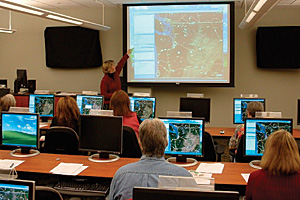
Pulaski Area Geographic Information System (PAgis)—The members of PAgis chose the theme "GIS to the Rescue" for their GIS Day event, based on the tornadoes and flooding that occurred within the state of Arkansas in early 2008. Dan Koch from the Little Rock National Weather Service demonstrated in his keynote address how GIS was used following the tornado outbreak. The mobile command center from the Little Rock Office of Emergency Management was on-site; attendees could take tours and see demonstrations of the unit's mobile mapping software. In addition, two Environmental and Spatial Technology (EAST) labs presented their projects: the Arkansas Natural Heritage Commission Box Turtle Survey and 3D Visual of Arkansas Veterans Cemetery using ArcGIS 9.2. Houston Area GIS Day—The popular expression "Everything is bigger in Texas" holds true for GIS Day. The Houston Area GIS Day event invited hundreds of businesspeople, educators, students, and the general public to partake in two days of products, services, and education centered on GIS. Day one was dedicated to adults and included a keynote message given by Colonel James R. Marrs, commander of the 480th Intelligence Wing, Langley Air Force Base, Virginia. Marrs highlighted how his department employs GIS in daily functions and what a vital component it is to administering homeland security. Following the keynote address, an exhibition hall of more than 20 exhibitors and numerous GIS presenters was open to the public. Day two focused on educating high school students about GIS and the possible degree and career opportunities in the field. With the help of generous sponsors, scholarships were awarded to teachers and college students who wish to advance their education in GIS. Washington State Department of Transportation—The Washington State Department of Transportation (WSDOT) GIS Support Team sponsored several GIS-related events that were open to all state employees. They included two lunchtime GIS seminars and a hands-on workshop concerning "getting your data into ArcGIS Desktop." WSDOT also demonstrated its custom version of ArcGIS Explorer. Events were held at both the WSDOT headquarters in Olympia, Washington, and in the Tumwater office.
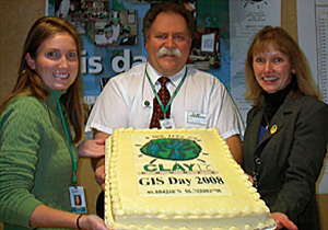
Clay County, Minnesota—"GIS Day 2008 was the best-attended GIS Day ever," says Mark Sloan, Clay County GIS coordinator. The event included demos of ArcGIS 9.3 software and Clay County's GIS Web site, a map/data gallery, and training sessions in the GIS lab. A GIS Day cake was enjoyed by all and gave members of the GIS Department time to talk with fellow county employees about how GIS could be applied in other areas. The event received excellent media attention, as an interview of Sloan was broadcast during two news reports that night. City of Las Vegas—The City of Las Vegas, Nevada, is a longtime GIS Day supporter. Jorge Morteo, GISP, from the planning and development department, has been giving GIS presentations in Spanish to English Language Learning (ELL) students since 2003. During Morteo's 2008 presentation, ELL students from Dell H. Robison Middle School viewed a demonstration of 3D ArcGIS Explorer models. They even got to use 3D glasses to view several 3D stereo view images. "There is a large Hispanic population in Las Vegas, and most of the students arrived in our city from other Spanish-speaking countries," shares Morteo. "As a former ELL student, I like to show students about the geographic location of their new home and about how we use GIS to analyze all types of geographic information data to solve problems. This way, we can have a better community and safe neighborhoods." Being a Hispanic immigrant himself, Morteo also shared his personal and professional background and encouraged students to value their education. Webcasts—Iowa State University, the Houston Area GIS Day, and the United States Army Corps of Engineers are just a few event organizers that utilized webcasts as a way to share their GIS Day events with others. "We decided to provide a webcast in order to reach a larger audience and make the information available to those people who are curious about GIS Day but can't attend the event," says Maria Vera, GIS coordinator, Houston TranStar, and member of the Houston Area GIS Day planning committee. Texas Water Development Board—With 10 years of GIS Day celebration, a tradition was born—GIS Day participants began creating amazing baked goods adorned with the GIS Day logo or GIS-related decorations. In 2008, the Texas Water Development Board had a new take on the tradition. The office recognized GIS Day with a Texas map made from hummus. GIS Day 2009It's not too early to start planning GIS Day 2009—Wednesday, November 18. Visit www.esri.com/gisday for details. |