Winter 2008/2009
Winter 2008/2009 |
|||||||
|
|
|||||||
The New Jersey Audubon Society Helps At-Risk Grassland Birds with GIS |
|||||||||
Highlights
There is little doubt that our grassland birds are in trouble. Partners in Flight (PIF), the coordinated body that monitors large-scale trends in North American land bird populations, recently identified 100 Watch List species, or those in greatest need of conservation attention. More than 20 percent of the species listed are considered grassland associated. Although there is some uncertainty as to what pressures are driving these populations down, likely contributors are the condition and availability of breeding habitats across the United States. In the northeastern region in particular (i.e., New England and the Mid-Atlantic), grassland habitats have undergone dramatic changes over the last century.
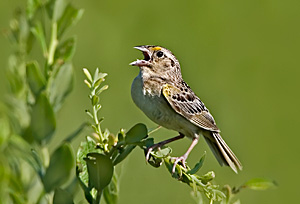
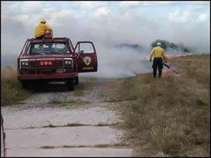
Immediately after European settlement, when woodlands were cleared for pastures and hayfields, grasslands were an extensive and important component of the northeastern landscape. These extensive tracts of land supported large, viable populations of several species of birds. Over the last century, however, the human population in the region has grown astronomically, farming has diminished, and many areas that were previously grasslands have been developed or have reverted to forests. In fact, much of the grassland area that still exists in the northeastern United States is on airfields, military training areas, and a vanishing number of remnant pastures and hayfields. For some grassland bird species, PIF recommends immediate intervention, while long-term planning and management and keeping close watch will be necessary to ensure the survival of others. In the northeastern region, many of these efforts will obviously need to take place on the airports and military lands that now house a large proportion of the region's grassland birds. One such effort was initiated by New Jersey Audubon Society (NJAS); Parsons Brinckerhoff (PB), an Esri Business Partner; and the South Jersey Transportation Authority (SJTA) at the Atlantic City International Airport (ACY) in 2004. The airport, located in the heart of the New Jersey Pine Barrens, supports the largest known breeding population of grasshopper sparrow (Ammodramus savannarum) and second largest breeding population of upland sandpiper (Bartramia longicauda) in the state. Both are high conservation-priority species in the region. The project was designed to mitigate potential impacts to grassland birds from proposed airport development by improving habitat conditions for the two target species on a select area of the airport known as the Grassland Conservation and Management Area (GCMA). To this end, several different mechanical methods, as well as controlled burning, were used to ward off encroachment by woody vegetation. Native grass and herbaceous species were also planted in some areas. The goal of NJAS was to assess the short- and long-term responses of grassland birds to these habitat restoration and enhancement activities by examining the spatial relationships of bird breeding activity to patterns of vegetative structure on the GCMA.
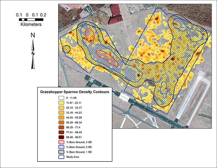
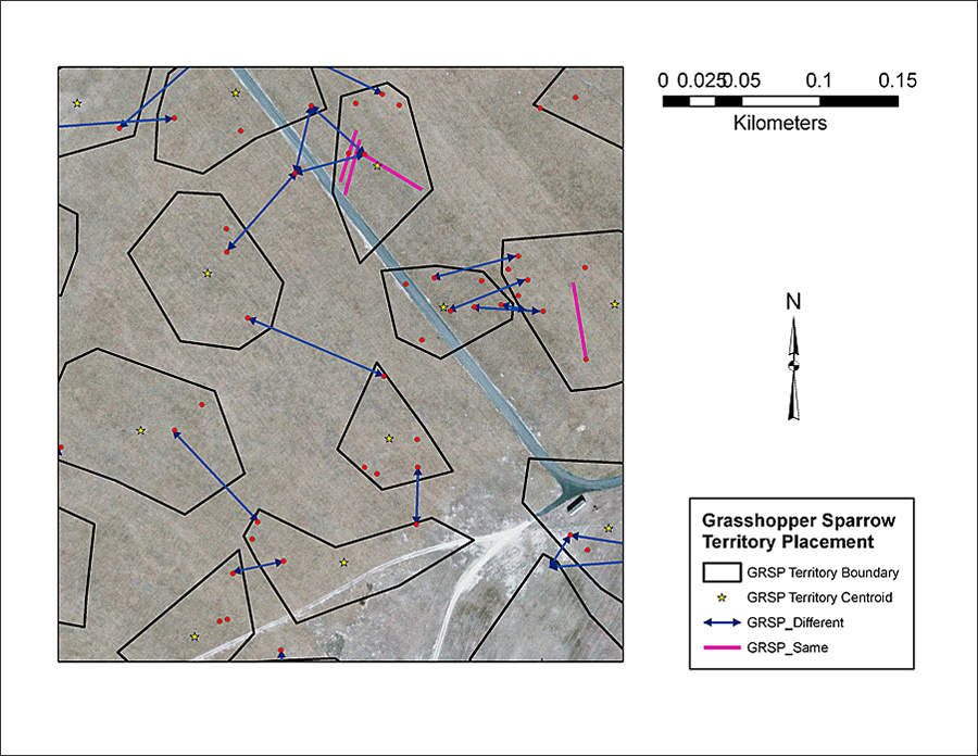
NJAS biologists involved with the ACY monitoring project have extensive experience with ArcGIS Desktop (ArcView) and ArcGIS Spatial Analyst, so use of these tools was the clear choice for conducting spatial analyses of grassland birds breeding at the airport. The spatial evaluations were geared toward six focal species, including grasshopper sparrow and upland sandpiper, and were based on two datasets generated each spring. The first consisted of point location data garnered from territory mapping efforts. Territory mapping entailed an observer recording the locations of territorial (i.e., singing) individuals on georeferenced grid maps. At each grid point, a digital range finder and compass were used to estimate the distance and direction to observed birds, thus generating a "snapshot" of bird activity on that day. Especially important were occasions of simultaneous singing by individuals close to each other, or "countersinging," and flights of birds between two locations. This data would help distinguish the boundaries of adjacent nesting territories and the spatial extent of individual habitat use. The data also could be used to highlight areas of elevated activity, or hot spots, on the study site. The second dataset consisted of basic vegetation data that was collected by PB at randomly placed sample plots around each grid point. Measurements were mainly structural and included average vegetation height, as well as percent ground cover of herbs, grass, and shrubs and percent bare ground. Back at the lab, NJAS biologists used ArcGIS Spatial Analyst to create separate density contours for each species. Contours were interpolated based on territory mapping point theme data from between 14 and 17 survey rounds combined for each breeding season. In this way, species-specific maps were generated that clearly showed areas of the GCMA where a majority of observed locations were concentrated. NJAS also used Spatial Analyst to create density contours for the vegetation data, based on average vegetation values recorded around each point. Then code was constructed to simplify the vegetation contours by converting them to polygon shapefiles depicting areas that had interpolated values that were one, two, and three standard deviations above the mean value for the study site. The biologists then overlaid these vegetation shapefiles on the density contours created for each species and examined habitat associations. Finally, based on observations of countersinging and individual movement, a polygon shapefile depicting estimated territory boundaries for each species was created. Territory centroids were identified using the field calculator in ArcView.
The maps created with ArcView and ArcGIS Spatial Analyst gave NJAS a bird's-eye view of the spatial relationships between birds and vegetation at the airport. It was the first step in conducting a full spatial analysis of the site, which will examine things like habitat use versus habitat availability and changes in bird distribution over time. Ultimately, NJAS will be able to assess the effects that grassland management at airports can have on birds, so that airfield managers can make informed decisions for bird conservation, as well as airport safety. To this day, grasslands remain one of the most rapidly disappearing land-cover types in the northeastern United States. Therefore, the conservation role of airports in this ever-changing landscape is sure to increase, and the ACY project will provide extremely useful information to airport managers well into the future. More InformationFor more information, contact Dr. Kimberly Peters, director of research and monitoring, New Jersey Audubon Society (e-mail: kim.peters@njaudubon.org). |