Winter 2008/2009
Winter 2008/2009 |
|||||||
|
|
|||||||
North Dakota Redesigns Forest Inventory, Assessment Programs Using GIS |
|||||
|
By Peter G. Oduor, Larry Kotchman, Gom Ale, and Jason Vinje Highlights
When the early settlers came to North Dakota, trees were so scarce on the prairies that homes were constructed from sod and heated with buffalo "chips." The homesteaders soon realized unrestricted winds and winter blizzards were not only an irritation but also a constant danger. The lack of trees for housing, fuel, fencing, and protection against the harsh environment quickly motivated them to plant trees. Most forest land back then existed in the Turtle Mountains, Killdeer Mountains, Pembina Hills, and the Devils Lake area and along major riparian corridors. The North Dakota Forest Service (NDFS) was established in 1906 to practice sound land stewardship to enhance and preserve forests, grassland, and wetland ecosystems found within the state boundaries. By 1954, the total acreage for protection plantings was 89,000 acres, earning North Dakota the distinction of having more protection plantings than any other state in the United States. To date, there are slightly more than 824,000 acres of forested land that include windbreaks. NDFS, with the help of the Federal Land and Water Conservation Fund, owns five state forests for hunters, hikers, campers, skiers, mountain bikers, snowmobilers, wildlife viewers, and other outdoor enthusiasts.
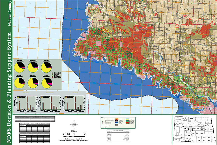
Following a period of technology assessment, NDFS, in partnership with North Dakota State University (NDSU) Department of Geosciences, developed a decision and planning support system using ArcGIS Server, ArcInfo, and Microsoft SQL Server 2005. The system included a geospatial database of all private and public forest land, including windbreaks. The rationale for constructing this system was threefold: to illustrate the driving forces or transition potentials and assess the dynamics of land-cover change; to understand the future economic and environmental implications of current and past conversion processes; and to serve as a means of projecting or forecasting and evaluating the impact of past, current, and future state and federal policy changes. Immediate geospatial benefits included an inventory of georeferenced, delineated stewardship tracts; community fire assessment demarcations; endangered species locations; a rapid database update module and intranet portal designed as a viewer of managed areas; and a direction finder for local and state response plans available to decision-making personnel. The project provided key information concerning not only resource potential and vulnerability but also the extent of professional management occurring around a given tract respecting private property rights and confidential information. Targeted or new landowners may find new opportunities to complement the activities already begun in a geographic area or learn of a need to protect their tracts from a significant vulnerability, such as fire threats or areas prone to soil erosion. The analysis provided an ability to conserve and consolidate forest patch size in critical areas, such as those deemed as high-priority areas. Foresters can now readily identify forest lands of high stewardship potential based either on richness of forest resources or on vulnerabilities, or a combination of the two. They can have enhanced information at their fingertips as they approach and work with landowners. Database DevelopmentWith ArcGIS, historic information regarding specific programs like Forest Resource Management, Wildfire Assessment, Red River Basin Riparian Project, Invasive Species, and Forest Stewardship and pertinent datasets from NDFS and several federal sources were sorted, sifted, and incorporated into the main database with accompanying metadata files. This was done to allow ease of sharing, enhance portability, and build topology. The main geodatabase was designed to maximize information quality, enhance utility, improve objectivity, and show transparency. Base datasets like digital elevation models (DEM), county boundaries, cultural features, public land, soils, public water supplies, streams (perennial and intermittent), priority watersheds and aquifers, riparian areas, forest health (gypsy moth locations), and transportation networks were also added. Accomplishments and Future Prospects
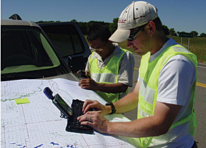
The project deliverables provided NDFS with a consistent methodology (while offering the ability to customize the support system according to future conditions) to spatially display important forest lands (rich in natural resources, vulnerable to threat, or both), existing stewardship tracts, and areas of opportunity to focus future policies. This will aid not only in stewardship plan preparation but also in implementation of conservation program practices. Any future analyses and assessments will lead to informed recommendations, considering the resources and vulnerabilities beyond the boundaries that a drafted recovery or assessment plan may address. From the decision and planning support system, NDFS foresters may recommend to landowners that practices be incorporated to add to conservation efforts within their land due to implemented efforts surrounding their property. Landowners may find new opportunities to complement the activities already begun in a geographic area or learn of a need to protect their tracts from a significant vulnerability, such as invasive insects or fire threats. Forest resource managers using the system will also be able to demonstrate connectivity in resource management efforts and ascertain how they complement other natural resource conservation efforts from federal and/or privately funded programs. Through time, they will be able to track the accomplishment of plan-prescribed activities—especially those in high-priority areas, such as riparian areas—and offer recommendations on areas serving identified critical resource management needs. TrainingA preliminary training workshop was conducted to help raise awareness among NDFS and support staff on the value and uses of the support system as they develop and visually portray North Dakota's forestry assessment and response plan outcomes. The participants from eight state offices, located in Bismarck, Bottineau, Carrington, Fargo, Grafton, Lisbon, Towner, and Walhalla, attended the GIS training session held at North Dakota State University. Most of the attendees currently work with private landowners and public entities interested in managing community, private, and state forest resources. About the AuthorsPeter Oduor is an assistant professor of geology and conducts remote-sensing and GIS research at North Dakota State University, Fargo. Larry Kotchman is North Dakota state forester and head of the North Dakota Forest Service at Bottineau. Gom Ale, currently pursuing doctoral studies, and Jason Vinje were research and field associates. More InformationFor more information, contact Peter Oduor, Department of Geosciences, NDSU (tel.: 701-231-7145, fax: 701-231-7149, e-mail: Peter.Oduor@ndsu.edu). |