Winter 2008/2009
Winter 2008/2009 |
|||||||
|
|
|||||||
Enterprise Platform Improves Planning, Analysis, and Emergency Response
Orange County Fire Authority Builds Advanced GIS Capability |
|||
Highlights
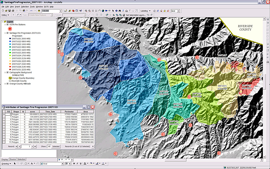
Today's firefighters are more GIS enabled than ever. More and more agencies use GIS to proactively plan and respond to events. One agency, the Orange County Fire Authority (OCFA), located in Irvine, California, stands out with an enterprise capability that impacts all aspects of its organization. OCFA is one of the largest fire departments in the state. Its center of operations, known as the Regional Fire Operations and Training Center (RFOTC), is a 20-acre complex that supports OCFA's community fire stations from a single, centralized location. The state-of-the-art facility includes a 9-1-1 emergency communications center, a vehicle maintenance hub, a material management shop, and a training grounds facility that includes a fire simulation tower. The agency successfully began using desktop GIS in June 1998 as a departmental solution to automate mapmaking methods. Maps have been a centerpiece tool for fighting fires for centuries, but OCFA had a vision to provide a true information platform built using GIS as the foundation. The goal was to use the enterprise architecture to bring people, processes, and workflows together in the same fashion it seamlessly linked data and applications from multiple sources.
"Spatial data is central to most of our services performed," says Joe Mangiameli, GIS manager, OCFA. "OCFA initially acquired GIS technology in a desktop solution without solid infrastructure support or a master plan for enterprise deployment. Our vision involved streamlining, standardizing, and centralizing GIS so we could ultimately make spatial data and applications available throughout the organization." "Service to our community drives everything we do," says Katherine Litchfield, information technology manager, OCFA. "We develop technology for strategic and tactical purposes by considering what our fire personnel need to get the job done and how we can best serve the public. Our mission is to protect life and property. GIS helps us carry out this mandate." The OCFAOCFA is composed of six divisions and eight battalions and serves 22 cities and unincorporated areas. OCFA operates 61 fire stations staffed with 841 career firefighters and 390 reserve firefighters. It maintains a service area covering 550 square miles and 120,000 acres of wildland and serves roughly 1.3 million people. The OCFA Operations Department provides regional emergency response to all fires, medical aids, rescues, hazardous materials incidents, and wildland fires, as well as aircraft fire and rescue services to John Wayne Airport. The agency implemented GIS and it flourished, but as growth occurred, the need for a more comprehensive GIS plan quickly arose. "We had an environment that consisted of limited GIS functionality, multiple platforms, and no GIS standards," explains Mangiameli. "There were also disparate spatial datasets and workflows, redundant layers of spatial information, and no central repository for spatial data. Many of the mapping products were produced in a legacy system that had limited information and inaccurate spatial data. There was a lot of work to do from a strategic, long-term standpoint." The agency developed a master plan for technology that included the Enterprise GIS Strategic Plan. The plan formed the road map to take the organization from its initial set of circumstances to the position of being able to leverage the full array of benefits that GIS technology has to offer. GIS Across the AgencyOCFA uses its enterprise GIS platform for planning, analysis, emergency response, and cartographic business needs. The agency uses the full suite of ArcGIS 9.3 software, including ArcInfo and ArcView, along with ArcGIS Network Analyst, ArcGIS 3D Analyst, ArcGIS Spatial Analyst, and Map Production System—Atlas (MPS-Atlas). In addition, ArcIMS and ArcGIS Server Advanced Enterprise are used for Web GIS capability. Esri Professional Services performed a number of implementation and consulting duties. Approximately 80 spatial data layers are maintained within the enterprise GIS environment. Included among these are land parcels; address points; streets; hydrants; jurisdictional boundaries; fire history; fire hazard severity zones; fuel modification zones; trails; and wildland and urban interfaces, which depict where flammable vegetation and homes are adjacent. GIS maps and analysis help determine the locations for new fire stations by mapping incident locations and response times to determine areas that require better service. The analysis weighs variables such as road networks, traffic congestion, and incident frequency. OCFA generates much of its own data but also gets GIS data from city and county departments, such as planning, public works, and utilities, as well as other public safety agencies, and generates maps depicting buildings, hydrants, streets, address locations, incident locations, and other data. Once these separate data layers are brought together and visualized, commanders can assess risks and prepare preincident plans. This may include adding extra hydrants, improving internal building protection systems, or increasing the number of vehicles and air support craft operating during a specific time period. This type of preplanning raises OCFA's preparedness capabilities and increases the probability of a successful response. GIS is deployed to provide OCFA staff with incident trend identification and to enhance the organization's performance. This is accomplished by providing maps and reports generated from computer-aided dispatch and a GIS-driven automated vehicle location (AVL) system. When fire trends within an area increase beyond normal predetermined benchmarks, fire officers can begin to examine causal factors. They can also observe if response times are within expected performance goals. OCFA also uses GIS to plan wildland fire defense strategies, perform fuel modification and inspection programs, plan for evacuations, and more. Better Serving the Community Now and into the FutureAccording to OCFA, the benefits from implementing the infrastructure, capabilities, and functionality of enterprise GIS go beyond the usual data sharing and improved efficiencies. They include streamlining and elimination of redundant activities, reduction of the time it takes emergency response vehicles to arrive at an incident, the ability to provide GIS data and tools to improve fire incident management during emergencies, and improvements in planning and risk management. "GIS maps and analysis help transform data into useful information," says Mangiameli. "GIS helps commanders and others quickly assess information integrated and rendered visually in a map for better decision making. This helps us better serve our citizens, and that's at the core of everything we do." Within OCFA's Enterprise GIS Strategic Plan, 46 GIS-related business needs were established. To meet these business needs, 23 GIS applications were identified, which include emergency incident pattern analysis, chemical hazard data mapping, inspection workload assignment, and arson analysis. More InformationFor more information, contact Joe R. Mangiameli, GIS manager, Orange County Fire Authority (e-mail: joemangiameli@ocfa.org, tel.: 714-573-6447). |
 While nothing will ever replace the single most important asset for fighting fire—people—advances in technology give today's firefighter more capability to protect life and property. And the new generation of firefighters is also the most tech savvy. Mobile computers, Web-enabled phones, virtual social networks: it's an integrated, multimedia world where technology and daily life are merging.