Winter 2008/2009
Winter 2008/2009 |
|||||||
|
|
|||||||
Netherlands Consulting/Engineering Company Debuts Environmental Information System Based on ArcGIS Server
Organizing Geographic Site Information in Six Languages |
|||
|
By Laurent Bakker, Tauw Group; Sandip Roy, RMSI; and Gaurav Verma, RMSI Highlights
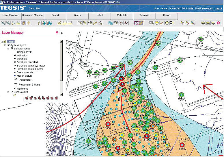
Tauw Group B.V., the Netherlands-based consulting/engineering company—and Business Partner of Esri Nederland B.V., Esri's distributor in the Netherlands—claims expertise in the natural environment, especially in water. Tauw calls on decades of water management experience to assist communities and companies to adapt to climate change and the resultant flooding and drought. The company's roots go back to 1928, when it began designing and constructing pumping stations in the polders (dike-surrounded low-lying tracts of land) of the Netherlands. Tauw has offices sprinkled throughout western Europe and affiliate relationships in more than 50 countries through the CAT Alliance of international environmental business consultants. In short, when something has to be built, Tauw is often called on for environmental consultancy and the monitoring of environmental quality.
In recent years, Tauw clients have been involved in even more geographically distributed remote sites in multiple regions having varied language bases. In response, Tauw developed the Tauw Enterprise Geographic Site Information System (TEGSIS) to provide easy and secure access to site information relating to, for instance, risk and liability asset management, compliance care and permits, and subaqueous soil and groundwater quality. TEGSIS is a Web-based GIS that organizes and shares information at the site level. Prior activities on many proposed industrial sites may have led to contamination of soil and/or groundwater. There is often a history of quality as described in soil and groundwater investigations. As soon as new buildings or other company activities are planned, the quality of the soil and groundwater needs to be assessed. It's clear that overview of data from existing investigations is necessary, together with activities that might endanger the quality of the soil. TEGSIS is a software tool that offers this needed worldwide access to environmental data. Tauw Enterprise Geographic Site Information SystemTauw originally had a desktop application that had its own database for every user. This led to severe management and data-sharing issues for various users of TEGSIS across the globe. Tauw had to invest considerable time and money in managing the data upgrades and data sharing. The old system required individual clients to use independent installations of the analytical software to get access to the dedicated database to support soil quality analysis. To overcome the above challenges, Tauw partnered with RMSI Private Limited, the India-based global geospatial and IT development company, to jointly lay out a road map and develop TEGSIS Web—a Web application based on ArcGIS Server technology. The application uses central storage of business and spatial data for all the business sites with authorized access to information through a three-tiered security model. RMSI was chosen as a preferred partner for development of TEGSIS based on the Indian company's proven experience in land parcel information systems and land-use planning. In addition, Tauw recognized that technology would be just one aspect of a solid solution, citing RMSI's staff for a reputed ability to meet deadlines and work in partnership. In its proposal, RMSI suggested ArcGIS Server for this project because of past experience with the technology. The resultant TEGSIS Web provides easy and secure access to site information. TEGSIS organizes information at site level with authorized access in six languages—English, German, French, Italian, Spanish, and Dutch. The site-specific reference frameworks, regional restrictions, and environmental obligations and legislation are constantly monitored to provide the legal compliance level of all the sites and individual boreholes and monitoring wells. Now, as soon as any authorized user accesses TEGSIS, the system provides thematically rendered site compliance information for all the accessible sites. A site can now be analyzed for various reference frameworks with spatial analysis for concentration of various chemical substances in the (sub)soil. With the integration of ArcGIS Server and real-time Web access, soil and groundwater parameters reported for boreholes and monitoring wells can be analyzed and monitored. The two-dimensional topographic reporting diagrams of boreholes and monitoring wells representing field observations and chemical properties can be viewed and printed. Timescale-based line graphs of chemical properties enable better decision making regarding possible remedial actions, temporary measures, or soil excavation works. Tauw's state-of-the-art expertise on content and understanding of local context were utilized to resolve the scientific, legal, and localization needs of a variety of clients through a single subscription-based platform. The borehole and monitoring well data can be either uploaded directly by clients through specially developed spatial and nonspatial data import tools (field GIS) or can be requested to be done through Tauw. This feature provides the analysis results of the latest soil and groundwater scientific data. Various spatial features can be associated with a privilege-enabled document management system that provides extensive information and acts as a ready reckoner. TEGSIS customers now have one solution for many of their spatial and scientific needs, as TEGSIS allows addition of pluggable modules made available through the subscription. About the AuthorsLaurent Bakker is director of the Industries, Soil, and Groundwater Department, Tauw Group. Bakker is a member of the management team of Tauw in the Netherlands and responsible for the innovation and knowledge exchange program regarding soil services within the Tauw Group. Sandip Roy is assistant general manager, SW Division, RMSI Private Limited. Gaurav Verma is project manager, SW Division, RMSI Private Limited. More InformationFor more information, visit www.tauw.com; contact Laurent Bakker, Tauw Group (tel.: 31-0-570-699622, e-mail: laurent.bakker@tauw.nl); visit www.rmsi.com; or contact Sandip Roy, RMSI Private Limited (tel.: 91-120-251-1102, e-mail: Sandip.roy@rmsi.com), or Gaurav Verma, RMSI Private Limited (tel.: 91-120-251-1102, e-mail: Gaurav.verma@rmsi.com). |