Winter 2009/2010
Winter 2009/2010 |
|||||||
|
|
|||||||
Mapping the Spread of White-Nose Syndrome with GIS
Disease Causing Steep Decline of Bats |
|||||
|
By Mylea Bayless, Bat Conservation International, and Zachary Wilson Highlights
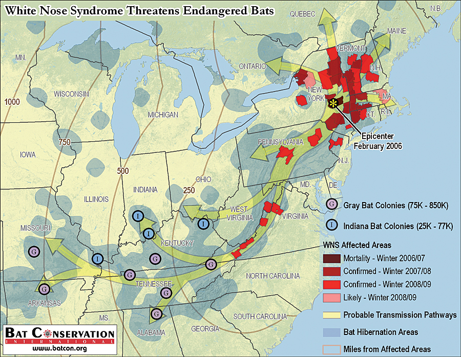
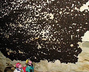
Caves have become graveyards for what biologists estimate as more than one million bats, the victims of a devastating disease known as white-nose syndrome (WNS).
Building on the work of its partners, Bat Conservation International (BCI) is using GIS to create a geodatabase of critical hibernation sites and map the probable spread of the disease. Understanding how WNS has spread and is expected to spread in the future will help biologists respond to the disease using surveillance and conservation actions. The first case of WNS in hibernating bats was discovered in a cave near Albany, New York, in February 2006. Since then, the disease is known to have killed bats in Connecticut, Massachusetts, New Hampshire, New Jersey, Pennsylvania, Vermont, Virginia, and West Virginia. Named after a cold-loving white fungus found on bats' muzzles and wings, WNS is linked to damage on wing membranes, excessive loss of limited fat reserves during winter, and death from starvation before spring. Since the disease was first discovered, WNS has spread rapidly across the eastern United States and affected six species of insect-eating bats (one of which, the Indiana bat, is federally endangered), causing mortality approaching 100 percent at some hibernation sites. The current losses are staggering, but biologists believe even larger numbers of bats and additional endangered species are at significant risk in the path of WNS. Why We Need to Protect BatsBCI, a nonprofit organization based in Austin, Texas, is committed to conserving bats and their ecosystems through worldwide partnerships, research, management, education, and outreach. Most North American bat species feed on night-flying insect pests that impact forests, agriculture, and human health. Globally, bats provide countless millions of dollars of ecosystem services, including insect/pest management, pollination, seed dispersal, and growing ecotourism appeal. Bats exist in every biome on earth except the extreme Arctic and Antarctic regions and are vital to maintaining balance in ecosystems. More than 1,100 species of bats worldwide account for nearly 20 percent of all mammal species, yet they are poorly studied and often neglected in conservation planning, leaving many bat species endangered or threatened with extinction. Now bats face another threat, WNS, which is causing the most precipitous decline of North American wildlife in recorded history. Such losses alone are expected to have unprecedented consequences on ecosystem health throughout North America, with unknown economic consequences. GIS—An Essential Tool for Understanding WNSGIS technology is helping biologists better understand the spread of WNS. Spatial analysis of currently affected areas and potential future spread is necessary for focusing efforts to raise awareness and promote preparedness. For example, states within the path of WNS will likely develop WNS surveillance plans and adjust their budgets to plan for the cost of a WNS response. BCI has a long history of working with state and federal agencies planning bat conservation activities but has never had in-house GIS capabilities. A few past projects have focused on developing geospatial datasets, but no long-term plan was in place for establishing GIS as part of day-to-day operations. In October 2008, BCI applied for and received an Esri conservation grant for ArcGIS software to support its new strategic plan to spatially enable the organization.
As WNS has progressed, Cal Butchkowski of the Pennsylvania Game Commission has used GIS to compile reports into a comprehensive map showing WNS-affected counties across the northeastern United States. Affected sites have been aggregated at the county level to protect sensitive cave and mine location information. Butchkowski's maps clearly show the spread of WNS across the landscape. BCI's conservation mission led to additional questions about the future spread of WNS and the threat it posed. BCI became concerned that WNS could reach hibernation sites housing the largest numbers of endangered Indiana (Myotis sodalis) and gray (Myotis grisescens) bats in the United States, but the organization did not have the data necessary to visualize the potential risk. Colleagues at the Pennsylvania Game Commission, U.S. Fish and Wildlife Service, West Virginia Department of Natural Resources, and others, provided data on the hibernation sites that housed the largest numbers of endangered bats. Using ArcGIS, BCI created an integrated geodatabase of critical hibernation sites and mapped the probable routes of future transmission of WNS based on georeferenced band recapture and radio telemetry studies. The resultant maps of the spread of WNS—created entirely using ArcGIS Desktop software's ArcMap application—have been widely distributed and were used in the congressional joint oversight hearing on WNS held June 4, 2009, which focused on increasing awareness about the current status of WNS and threats posed by its future spread. The maps helped illustrate that WNS is no longer a regional issue but has quickly become a national crisis and has the potential to affect bats internationally. Based on the testimony of bat experts during the hearing, it became apparent that current funding for WNS research and monitoring is inadequate. GIS capabilities at BCI enabled researchers to clearly articulate the urgency and ecological risk of WNS. GIS will also help BCI raise money to achieve its conservation mission. Geospatial data and maps have a growing value in securing funding for nonprofit conservation work. Proposal applications are often limited to one or two pages of narrative to capture the need and planned use of potential grants. The addition of maps allows BCI to convey the scope of the problem and work area at a glance without exceeding space constraints for the proposal text. The future opportunities GIS will bring to BCI are exciting, both to explore conservation issues and articulate BCI's mission. About the AuthorsMylea Bayless is a conservation biologist who focuses on white-nose syndrome, southeastern rare bats, and bats in bridges. Zachary Wilson is an independent GIS consultant. More InformationFor more information, contact Mylea Bayless (e-mail: mbayless@batcon.org). BCI graciously acknowledges the support and investment of its many partners and funders—including the Beneficia Foundation, the Department of Defense Legacy Program, Disney's Rapid Response Fund, the Kabcenell Foundation, the National Fish and Wildlife Foundation, the National Park Service, the Nina Mason Pulliam Charitable Trust, the U.S. Fish and Wildlife Service, the U.S. Geological Survey, the Wallace Global Fund, Esri, and other numerous state and federal agencies responsible for managing our nation's wildlife. The following links provide the latest information on white-nose syndrome: www.batcon.org/wns, www.fws.gov/northeast/white_nose.html, www.nwhc.usgs.gov/disease_information/ white-nose_syndrome, and www.fort.usgs.gov/WNS. |