Winter 2009/2010
Winter 2009/2010 |
|||||||
|
|
|||||||
Enterprise GIS Connects Utility's Many Divisions |
|||||||||
Highlights
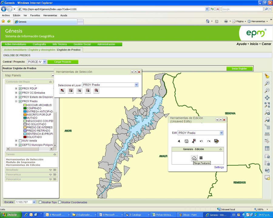
Nestled in Colombia's Aburr� Valley, a northern region of the Andes Mountains, is the city of Medell�n, with a population of 2.4 million and a greater metropolitan area with more than 3.2 million inhabitants. As Colombia's largest public service company, Empresas P�blicas de Medell�n (EPM) provides the area with water, natural gas, subscription television, wastewater treatment, and telecommunications services. The energy generation department of EPM is responsible for electric generation and marketing in Colombia's wholesale power market. The company operates 21 generating plants—19 hydroelectric, 1 thermal by gas, and 1 wind—and is developing two more hydroelectric projects. For more than a decade, each division of EPM has worked independently, analyzing and processing business information with GIS tools. However, separate efforts have led to fragmentation of information, resulting in inconsistencies, redundancy, difficulties in data sharing, lack of data integrity, little or no use of standards for data management, and insufficient security schemes for information management. EPM decision makers realized that the company's information needed to move to a cohesive geographic information center that would allow integration, data sharing, interaction between processes, and an IT environment that spans all divisions in the organization. With ArcGIS technology from Proc�lculo Prosis S.A., Esri's distributor in Colombia; consulting services from a local firm, Integral-Servinformaci�n; and the support of Universidad de Antioquia, EPM designed and is now implementing an enterprise GIS. The project includes an enterprise geodatabase, customized applications for all business processes, data conversion and loading, standards creation, policies and procedures for information acquisition and management, and management of cultural impact on users.
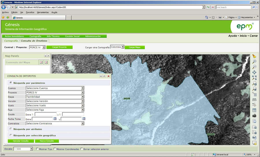
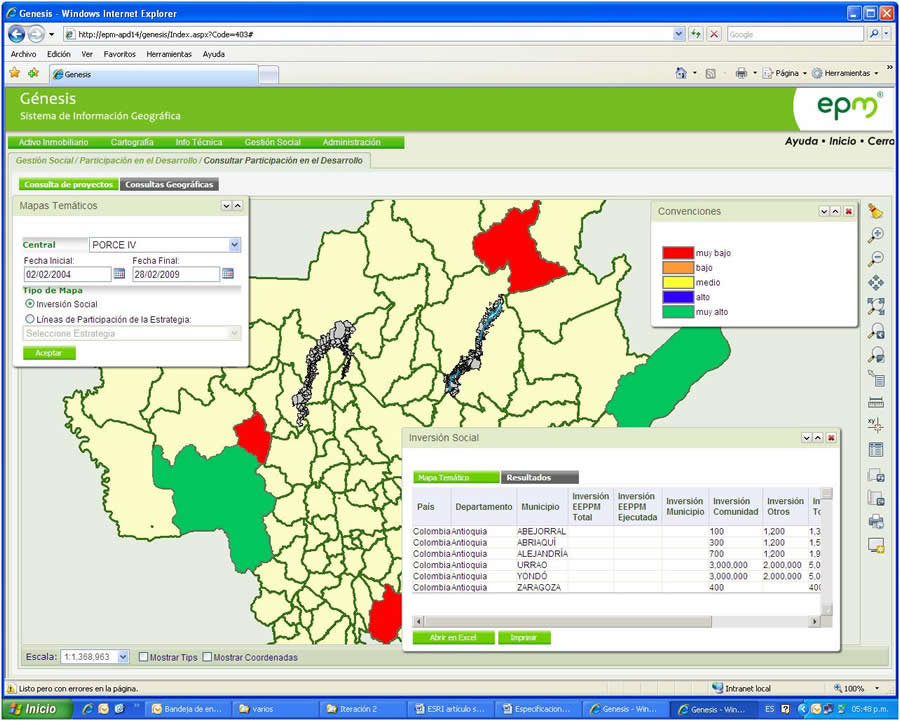
Before starting the GIS implementation, EPM posed some important questions. What are the current and future geographic information needs? What is the quality, amount, and relevance of existing information to support business operation and expansion? How should standards, policies, and procedures be defined considering the organizational culture and the need to share information between divisions? What is the best technological architecture—equipment, programs, applications, and procedures—with which to implement GIS so that the various existing platforms and applications can be integrated? What is the quickest way to get users to learn the new tools and assimilate into the new system? Following an intensive evaluation, EPM chose ArcGIS, then chose to bring the system into operation in stages, gradually giving users the functionality and geographic information they required. Thus far, users have benefited from access to reliable data that is consistent with the company data model, designed according to power generation requirements. Through customized applications, information is automatically updated and made available between divisions in line with EPM's set standards, procedures, and guidelines. Users have access to a workflow that allows information management, editing, and querying via the Web. Since upgrading to enterprise GIS, EPM is starting to see a reduction in the cost of information acquisition, updates, and maintenance. The objective of EPM's enterprise GIS is to support users across the company. Many departments now rely on base and thematic mapping for the regions of Central America, South America, and Colombia to view projects and assets geographically. Maps include data such as streets, natural resources, electric lines, cadastral information, community requirements, and infrastructure. The company has also enhanced basemaps with aerial photographs, satellite imagery, and orthophotographs.
EPM is using ArcGIS Desktop tools, including the ArcGIS Spatial Analyst extension, for asset and vegetation management, as well as routing and planning. With so much data shared across the enterprise, including historical information, EPM will be able to respond quickly to claims and work in the field. The GIS further allows sharing of data with agencies such as regional autonomous corporations, municipalities, and the Department of Antioquia, allowing cost and time savings. New-Generation DevelopmentIn new-generation development, EPM will rely on GIS for the entire project life cycle. In site location, EPM will use ArcGIS to define flood areas for new reservoirs and identify hazards or threats. With GIS-based cadastral management, EPM is able to optimize the prioritization process and land acquisition tracking based on the project's construction progress. This reduces the risk of unnecessary purchases and makes it easier to determine which parcels should be bought and when to buy them. Within GIS, decision makers perform comparative analysis of land prices based on land area, build area, enhancements, slopes, and crops. EPM will also employ ArcGIS software-based models and maps to help reduce risk in case of floods, earthquakes, landslides, and material deposits. The company is prepared to make better decisions in a catastrophic event because GIS enables rapid determination of risk sources and identification of evacuation alternatives. EPM can easily find data such as population, census, and affected properties assessments.
Land management, including parcel appraisal and property control, is now completed in a Web environment through a customized GIS application. With GIS-based modeling, project design and construction maps can quickly account for technical and environmental aspects. Further support of environmental management is achieved through predictive analysis and impact simulations. EPM monitors each project's zones of influence through forest applications, land-use changes, species studies, and environmental impact reports. More InformationFor more information, contact Mar�a Victoria Uribe, systems analyst, Empresas P�blicas de Medell�n (e-mail: maria.uribe@epm.com.co, Web: www.epm.com.co). |