Winter 2009/2010
Winter 2009/2010 |
|||||||
|
|
|||||||
Boulder County Parks and Open Space Creates Innovative GIS-Based Tool
Managing Agricultural Water Resources Successfully |
|||||
|
By Kristi VanDenBosch, Boulder County, Colorado, Parks and Open Space Department Highlights
The Boulder County, Colorado, Parks and Open Space (BCPOS) program began in 1975 as a single property—the 101-acre Bald Mountain Scenic Area. Since that first acquisition, the BCPOS program has grown to more than 97,000 acres, including directly owned properties and conservation easements held over private property. These properties range from subalpine ecosystems along the Continental Divide to the agriculturally productive lands of the high plains. This land investment is worth more than $317 million, paid for by the citizens of Boulder County. In addition to the land, BCPOS has purchased numerous water rights. These water resources have a value in excess of an additional $60 million. The BCPOS program has the responsibility to manage these resources for diverse, and sometimes competing, purposes, including preserving critical ecosystems and natural resources, the agricultural heritage of Boulder County, and historic and archaeological landmarks; sustaining scenic vistas; maintaining urban shaping between or around municipalities; and providing public recreational opportunities.
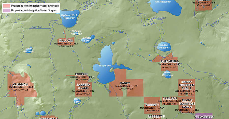
The largest use of water in the open space system has been, and is likely to remain, the agriculture program, which encompasses 45 percent of the fee-owned property and uses. The agricultural program operates by leasing lands and water to local private farmers. These farmers, within the framework defined by Boulder County, make production decisions: which crops to produce, which products to apply, and when and how much to irrigate. The county's responsibility is to provide sufficient resources to allow farmers to maximize their production and to offer technical assistance, guidance, and oversight. Making decisions about the management of water resources for agricultural production requires a thorough understanding of complex information, including climatic conditions, natural and artificial water systems, agricultural practices, and legal conditions. BCPOS recognized that with a better understanding of the spatial distribution and relationships of these resources, managers could make better decisions. For example, knowing where water supply is insufficient for production can help staff make decisions about which water to add to the water portfolio or where to focus irrigation conservation methods. This information can also help clarify agricultural water resources decision intricacies for nonexpert decision makers by clearly laying out methodologies and representing results in a graphic format. The AgHydro ApplicationSince 1987, GIS technology from Esri has become an integral part of almost all Boulder County's governmental functions: property assessment; land-use and zoning issues; road construction and maintenance; emergency and law enforcement; snowplowing; open-space acquisitions, operations, and management; wildfire mitigation; health concerns; and precinct delineation. In recent years, BCPOS designed a GIS, named AgHydro, to better inform the human decision-making process for managing the water resources of Boulder County. The system was created using ArcGIS 9.3 software. The GIS integrates data from various formats, locations, and spatial scales. Spatial data used in the GIS is primarily vector data, such as the agricultural field delineations and hydrological features. All spatial data is housed in ArcGIS Server. This enables BCPOS to control the editing process to ensure quality data through versioning. Tabular data resides mainly in Oracle relational databases, with some data stored as geodatabase tables. BCPOS has an existing agricultural database that tracks information on all the agricultural management activities that occur on open-space properties. Information in this database includes the types of crops planted; amount of irrigation water, fertilizer, and pesticides applied to these crops; and crop yield at harvest. The crop type is used to determine the irrigation water requirement for each field and property. BCPOS also maintains an Oracle database designed to inventory and manage property, mineral and water rights owned by the county, and agricultural leases administered by BCPOS. Using the analytic tools available in ArcGIS Desktop, such as the ArcGIS Network Analyst and ArcGIS Geostatistical Analyst extensions, the BCPOS AgHydro GIS enables decision makers to better understand the real-world elements and complex relationships of a given problem or scenario. The AgHydro application increases the level of understanding of the components comprising the county's land and water resources. Understanding the individual components allows managers to better understand the effect that the components have on the irrigation system and agricultural processes as a whole. Other variables that are not included in the GIS may need to be considered, such as the price and availability of water, Boulder County community values, and legal constraints. Highland Ditch
The most valuable information that resulted from the spatial analysis was the amount of water available for supply and the calculated water demand for each property in the Highland Ditch study area. BCPOS staff members were aware that there was an irrigation water deficit on the properties irrigated under the Highland Ditch, but the ArcGIS software-based AgHydro showed these properties to be even more depleted than the general perception—over 100 acre feet short in some cases. Knowing both that these properties are water short and the extent of that shortage, as well as the effect of different agricultural and water management approaches, will help staff make better management decisions, such as fully evaluating an opportunity to purchase additional water or installing infrastructure to maximize the irrigation water potential. AgHydro enables the BCPOS data to be combined in many ways to provide further insight into agriculture and water management, whether it is examining data at different scales or running different scenarios to examine the various outcomes. For example, additional information, such as ditch run dates, the price per unit of water, and the potential properties that a given unit of water can serve, can give further insight into prioritizing potential water purchases in the future. Subsets of data can be isolated so that managers can examine results between years, within selected water systems, or for a given crop. Gut Instincts Can Fail"The GIS proved to be a valuable tool in increasing our understanding of the agricultural water distribution system and increased the quality of our decision-making process," says Rob Alexander, agricultural specialist at BCPOS. "Our confidence in decisions about where to allocate our budget and how to manage our irrigation water resources is now based on a much greater foundation of accurate information. In many cases, our educated �gut instincts' can be way off. We thought that our on-the-ground knowledge after 13 years would be sound and that decisions based on that knowledge would be good ones. Turns out we were wrong. In some cases, we were not even close." Based on these results, BCPOS plans to expand the project from the current pilot project area to cover the water distribution systems countywide. About the AuthorKristi VanDenBosch is a GIS analyst with the Boulder County Parks and Open Space Department with an M.S. in GIS and watershed science and nine years of GIS experience. More InformationFor more information, contact Kristi VanDenBosch, Boulder County Parks and Open Space Department (kvandenbosch@bouldercounty.org). |