Winter 2009/2010
Winter 2009/2010 |
|||||||
|
|
|||||||
Government Seeks 100 Percent Electrification in Urban Areas, 60 Percent in Adjoining Areas
Restoring Angola's Electricity Network |
|||||
Highlights
Angolans have suffered three decades of civil war, and only in recent years have they been able to begin the slow process of reclaiming their nation by rebuilding both the physical and social infrastructure necessary for peace, security, and economic growth. A critical component of this progress is the restoration of the electricity network. The government of Angola has set a goal to provide 100 percent electrification in urban areas and 60 percent electrification in adjoining areas by 2012. The U.S. Agency for International Development (USAID) is assisting Angola's government in reaching this target. A pilot project is under way to address the electrification goals, piloting innovative methods to improve electrification in the adjoining areas.
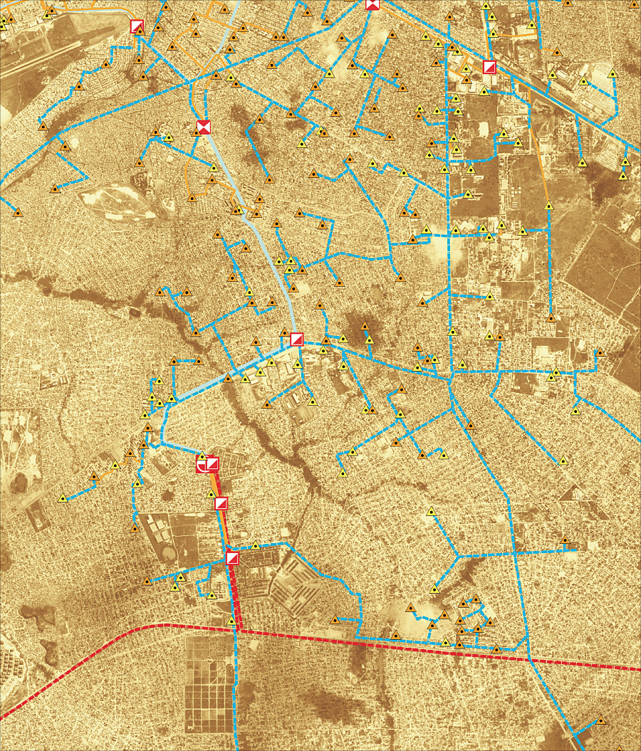
To address this need, the Academy for Educational Development (AED), a leading nonprofit organization working globally to improve education, health, civil society, and economic development, is working with Empresa Distribuidor de Electricidade (EDEL), Angola's national electricity distribution company, and two municipal governments to provide training in urban planning, engineering, and capacity building through the USAID-funded Angola Electricity Support Program (AESP). Closing Information GapsUp-to-date maps are essential for planning and managing municipal infrastructure. Cadastral maps are critical for granting land titles and acquiring data necessary to establish an electricity connection. Prior to the launch of AESP, the most recent cadastral maps available in Angola dated back to 1989, a serious barrier to the design and implementation of electricity access programs. "Providing electricity to homes and businesses requires more than just installing poles and stringing cable," says Joao Baptista Borges, the chief executive officer of EDEL, which provides service to more than 7 million people in and around Luanda. "Maps, census, customer, and infrastructure data—which are outdated or nonexistent in Angola—are fundamental in planning for and providing electricity." One of the first activities under AESP was the systematic gathering of information about community resources, households, and infrastructure already in place in the pilot areas. AESP employed ArcView software to introduce its Angolan counterparts to GIS in order to develop accurate baseline information on residences and businesses in the municipalities of Kilamba Kiaxi and Viana. The information collected through surveys and site visits was added to geographic data and maps to create the most up-to-date geographic information systems for the two municipalities. AED selected ArcView based on Esri's reputation and because the software is easy to use for inputting and manipulating data for utility, governmental, and community use. The newly created maps contain information on land plots and existing electric networks and are providing EDEL with vital information, such as street addresses, meter numbers, and where houses are connected to the electrical system. That information will help EDEL deliver more accurate electricity bills, provide better customer service, and extend the network.
A further breakdown of the layered datasets provides information detailing the extent of electrical infrastructure. With this information, AED and local stakeholders were able to gather and analyze trend information and establish a concrete understanding of who was benefiting from electricity, differentiating between legal and illegal connections and identifying which households were not electrified. A Sustainable InterventionIn addition to upgrading the quality and type of information available, there is a capacity-building component to AESP. To date, EDEL and municipal government staff have been trained on the use and application of ArcView software and GIS principles. The training was so successful—and the software so useful—that EDEL has secured its own ArcView software licenses. As this project continues, training has been expanded to local stakeholders, including small businesses, civil servants, and residents. Within a forum of open dialog and transparency, municipal governments will have increased opportunities for iterative planning, flexibility, and adjustment. This will lead not only to improved electrical infrastructure but also to increased capacity through collective engagement, planning, and improved governance practices. Community members in the AESP pilot areas place a high value on the information that has become available to them through the application of GIS. Equipped with information, community groups and individual households are better able to communicate their needs to EDEL and advocate improved service. GIS has forged new paths and shed new light on underutilized power sources, forecasting, and long-term capital planning. AESP has increased access to electricity or improved electricity service for more than 6,500 households. Another 25,000 households will be supplied with electricity in 2009. More InformationTo learn more about the Angola Electricity Support Program, contact Mary Worzala, director of energy programs, AED (tel.: 202-884-8034, e-mail: mworzala@aed.org). |