Winter 2009/2010
Winter 2009/2010 |
|||||||
|
|
|||||||
Vegetation Management Goes Mobile |
|||||||
Highlights
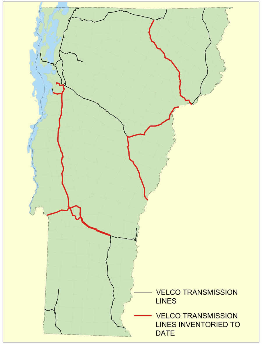
The Vermont Electric Power Company's (VELCO) 688 miles of high-voltage electric transmission lines and 12,000 acres of rights-of-way share space with a wide and colorful variety of plant life. There are ferns, azaleas, holly, laurels, blackberry bushes, cedars, maples, and oak trees—more than 75 different types of vegetation. All of it needs to be managed, and any vegetation that exceeds a mature height of 12 feet needs to be removed. VELCO developed an innovative vegetation management program that is saving the company hours of work, assisting in compliance, and significantly improving accuracy of treatment on its rights-of-way. Located in Rutland, Vermont, VELCO was formed in 1956 when local utilities joined forces to create the nation's first statewide, transmission-only company in order to share access to clean hydroelectric power and maintain the state's transmission grid. VELCO's Vegetation Inventory Program (VIP) creates orthophotographs and field data, making information seamlessly accessible to workers in the field and the office. The company's integrated vegetation management plan recently received a "superior practice" designation from the Transmission Owners and Operators Forum (TOOF). TOOF was established in 2008 by the North American Electric Reliability Corporation (NERC) as a roundtable for transmission owners and operators to exchange information on best practices for reliable operations. The VIP solution started to take shape when VELCO's team lead for CAD/GIS, Jarrod Harper, was asked to assist in evaluating and recommending a vegetation management system for the utility based on GIS technology. The decision to develop a customized system led Harper to Esri's ArcPad, which provides field crews with the ability to capture, edit, analyze, and display geographic information. Esri's ArcPad Application Builder served as the development framework for the customized VIP ArcPad application for mobile GIS.
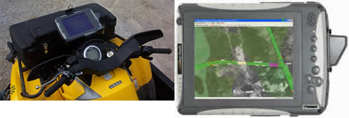
Once VELCO was equipped with the necessary technology, Harper spent several hours with the company's rights-of-way manager, Jeff Disorda, to understand the vegetation management team's workflow. When Harper returned to the office, he started writing code. Within a month, the VELCO VIP system was implemented. "We tailored the vegetation management system to specifically fit the workflow for our crew in the field," Harper says. "Crews had been limited to working with handwritten sheets and did not have access to environmentally sensitive data while out in the field. With the GIS application, they now can get very specific about where there is a need to use an herbicide or manually cut a tree." Harper also performed a technology evaluation to determine what crews needed in the field. The crews wanted access to orthophotographs for VELCO's entire system without having to do data swaps, so VELCO invested in Tablet PCs. Orthophotographs are aerial photographs that have been geometrically corrected to remove distortion caused by camera optics, camera tilt, and differences in elevation. An orthophotograph has the positive attributes of a photograph, such as detail and timely coverage, along with the positive attributes of a map, including uniform scale and true geometry. The Tablet PCs offered both a larger viewing screen and more storage capacity, which the data and orthophotographs required. Within ArcPad, Harper was able to create a tool that automatically loads orthophotographs wherever the user clicks the screen, without requiring the user to browse through a directory of images for the correct file. "The orthophotographs contained within VELCO VIP provide crews with an accurate reference to what is on the ground," Harper explains. "As crews walk the rights-of-way, they have an idea of how it will look as they move forward, which helps them navigate more effectively." VIP allows the vegetation management team to map the rights-of-way areas that are to be treated, which helps maintain VELCO's high reliability. The collected field data is downloaded from the Tablet PCs to ArcGIS Desktop to create map books. The use of map books enables VELCO to facilitate communication with contractors and expedite the State of Vermont's herbicide permit process.
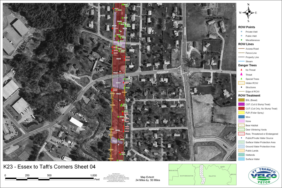
"Within the GIS-based map book, we are able to identify all the environmentally sensitive areas, and we can show the state regulators precisely how our rights-of-way will be treated," Harper says. Information in the map books includes environmental layers, such as rare, threatened, and endangered plant species; deer and bear habitats; wetlands; surface waters; and public or private well locations. Rights-of-way access roads are also shown to ensure that vegetation contractors have proper access. Each mapped polygon has an accompanying code that corresponds with a data table detailing height class, vegetation type, treatment type, restrictions, comments, area in acres, and transmission line number. Dangerous trees—trees that must be cut—show up in red on the map, along with a data table that includes diameter class, species, longitude, latitude, altitude, and line number. The VIP system can be queried to reveal a tree's treatment type, whether and by which method the tree has been marked, whether it's a threat, and whether GPS points have been logged. A green tree is the designation for special trees—those in the rights-of-way that are allowed to grow up to 12 feet, such as Christmas and fruit trees. For public and private water wells, the application automatically adds a 100- or 200-foot buffer.
Although the VELCO VIP system was designed for the company's vegetation management department, it has been adopted by other VELCO departments. VELCO VIP is also being used for company work with helicopter line patrols, telecommunications, and the line crew. "VELCO VIP has far exceeded our expectations and is a powerful tool that helps VELCO continue to serve as Vermont's transmission reliability resource," Harper concludes. More InformationFor more information, contact Jarrod Harper, team lead for CAD/GIS, VELCO (e-mail: jharper@velco.com, tel.: 802-770-6223). |