A Better Way to Protect Schools
City of Rancho Cucamonga, California, Builds Its Own Tactical Response Application
Highlights
- The Emergency Operations Center application uses ArcGIS Server for .NET and ArcGIS API for Flex.
- With GIS as a bridge, fire and police leadership can take full advantage of the tools available.
- GIS layers include streets, schools, parcels, city facilities, fire stations, police stations, banks, hospitals, commercial buildings, industrial buildings, and parks.
No matter how safe a city may be, it's never safe enough, especially when it comes to schools.
The City of Rancho Cucamonga is a premier city in the Inland Empire of Southern California. Located roughly 35 miles east of downtown Los Angeles, Rancho Cucamonga maintains a population of roughly 180,000, which includes thousands of students at more than 30 different schools. Rancho Cucamonga is also one of the safest cities in the country, according to the Uniform Crime Report, released annually by the FBI. And the city is growing. Recently, the California Retail Survey identified the city as the ninth-fastest-growing retail market in California.
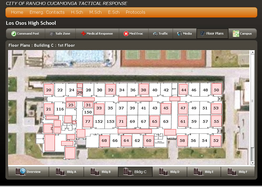
Detailed floor plans gives responders an accurate understanding of the layout.
In an effort to ensure that Rancho Cucamonga remains one of the safest communities in the country and, most importantly, continues to provide the best protection possible to its student population, city staff developed a program to deal with school campus emergencies. The goal was to make critical information available quickly and easily when an emergency strikes.
The result is a tactical response application known as Active Shooter.
The idea originally came from the city's police department. Looking for ways to better protect students, the agency learned about the use of technology to capture and maintain tactical emergency response information—such as school building plans, road networks, and emergency exits—in a digital environment. That information could then be linked to live data feeds and used immediately, and more effectively, in the event of an emergency.
After looking at different vendor offerings, the city had some difficult issues to address. First, none of the offerings provided exactly what the city wanted. Second, there were cost issues.
In 2008, the city formed a committee to look at solutions used in other cities and to make recommendations for its own solution. The committee also considered application interface design, with the key stakeholders being responders and not technology professionals, as well as deployment methods, training procedures, and cost and funding issues.
After an unsuccessful attempt to obtain a federal funding grant, the committee proposed building an in-house application.
"We didn't have any money to spend, so we built the application using the software and tools we already had," says Ingrid Y. Bruce, GIS/Special Districts manager, City of Rancho Cucamonga. "Plus, we have an outstanding GIS staff and resources, and we had active partners who could show us exactly what they needed to be successful."
"Other cities had Web architecture designs," says Solomon Nimako, GIS/fire analyst, City of Rancho Cucamonga. "We wanted something stand alone, independent of connectivity issues, or even something that could be used in the vehicles. Ease of use was very important."
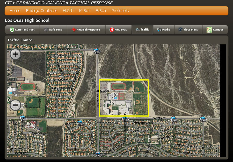
Staff can integrate aerial photography with other data. Here a traffic control perimeter is created.
Los Osos High School was chosen for the pilot project. The committee visited the school and met with the principal and safety staff.
With participation and buy-in from all the right stakeholders, the city, led by GIS staffers Bruce and Nimako, designed and developed Active Shooter. Training provided by the sheriff's department was then made available to both field staff and personnel working in command centers.
The Active Shooter application has two different versions—one for field use and one for use in command centers.
The field version runs from a flash drive and supplies situational maps of school facilities and emergency response plans to law enforcement, fire, and emergency medical services personnel. The maps enable any first responder to pan and zoom to a school floor plan at different levels. The field version also provides digital access to tactical response data in the event of a school emergency, such as a school shooting or hazardous chemical spill.
Field personnel can look at digital maps of the entire high school, including roadways, outdoor facilities, and parking lots. Designated safe zones, medical response and evacuation areas, traffic, and other data are available. They can also view floor plans showing classrooms, hallways, entry points, and more. In addition, preestablished response protocols for all types of emergencies are available through the application.
The Emergency Operations Center (EOC) version of the application is built using Esri server technology—ArcGIS Server for .NET and ArcGIS API for Flex. The server application lets staff perform query and search activities, draw notification zones, export information using a simple Web interface, and more. The application has a GeoRSS feed that is linked to the dispatch center database to supply a live feed of incidents.
For instance, if an emergency call comes in reporting a toxic gas release, EOC staff can view the emergency call and the location of the reported incident on campus, as well as live camera feeds, weather data, traffic data, any established safe zones, and feeds from personnel responding to the event, whether they are fire, police, or emergency medical services.
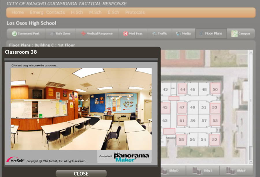
A panoramic view of a classroom is just one of the visual data types accessible using Active Shooter.
Prior to the development of the Active Shooter application, data management was paper-based. Binders containing all school emergency response protocols were kept in the watch command's office and the trunks of law enforcement vehicles. City officials updated the binders once a year with new, static images.
"We had limited information, and it was in a cumbersome format," says John Gillison, assistant city manager, City of Rancho Cucamonga. "GIS gives us the ability to access more information, faster. And now we can do more with it using analysis and visualization."
The application provides first responders with a common operational picture (COP), enabling multiple first responders to communicate using the same information while en route to an incident. The detailed floor plans of schools can be combined with panoramic photo views of classrooms and other buildings. This gives responders both an in-classroom understanding of the area of concern as well as a macrolevel understanding of the school layout. It also allows every agency—whether it's fire, police, emergency medical services, school, or others—to view any road closure or specific medical response information available.
GIS layers include streets, schools, parcels, city facilities, fire stations, police stations, banks, hospitals, commercial buildings, industrial buildings, and parks. The city's GIS division creates and maintains the layers. The system allows staff to create additional operational layers if needed during an incident. In addition, contact information of key persons and standard protocols are available with the touch of a button.
"Any deputy sheriff can access vital school layout data and identify the location of the call," says Joe Cusimano, captain, San Bernardino County Sheriff's Department. "More importantly, it supplies the same single common operating picture to all emergency responders."
With the initial success of Active Shooter at the Los Osos campus, the city is looking to expand the application to include all schools—including elementary and middle school.
In partnership with the San Bernardino County Sheriff's Department, Rancho Cucamonga Fire Protection District, and 5 school districts that serve the area, the city applied for and was subsequently awarded a federal COPS grant to implement the Active Shooter Response Program in 11 Rancho Cucamonga schools, including all the high schools and middle schools, which are especially susceptible to school violence. The grant includes funding for all the necessary field equipment, technology, and personnel to implement the program into these schools, enhancing the safety of 16,800 students. City staff is currently seeking additional grant funding to implement the application into the remaining schools in Rancho Cucamonga.
With new funding, the expanded application could then move to other locations, such as city hall, city courthouses, major shopping centers, sports facilities, parks, and other high-value locations.
"This program has opened the door to a new level of collaboration between historical silos in the public safety arena," says Mike Bell, fire chief, Rancho Cucamonga Fire District. "With GIS as a bridge, fire and police leadership can take full advantage of the tools available and leverage them for maximum benefit for their responders in the field."
For more information, contact Ingrid Bruce, City of Rancho Cucamonga (e-mail: Ingrid.Bruce@cityofrc.us).