eCoastal Program Fosters an Enterprise Approach to Data Management
United States Army Corps of Engineers Protects 12,000 Miles of U.S. Coastline
Highlights
- Program users search by keyword or category, then load data directly from their own or other Corps districts.
- ArcGIS software-based applications support the development of enterprise GIS in and across coastal divisions.
- The eCoastal program gives districts the analytic tools, best practices, and data structure they need.
From the beaches of Hawaii to the harbors of Maine, the United States Army Corps of Engineers protects and restores the shoreline many people call home and even more call the ![]() perfect vacation spot. Though images of peaceful waters and pristine sand may be fixed in our minds, the more than 12,000 miles of U.S. coastline are fragile and ever changing.
perfect vacation spot. Though images of peaceful waters and pristine sand may be fixed in our minds, the more than 12,000 miles of U.S. coastline are fragile and ever changing.
As they address issues such as coastal flooding, navigation, regional sediment management, erosion, and hurricane damage, Corps districts, like the Mobile (Alabama) District, collect unique data to support engineering, environmental, and economic decisions. Their projects require information such as regional coastal mapping data, the date and time shoreline imagery is collected, detailed designs of coastal structures, and much more.
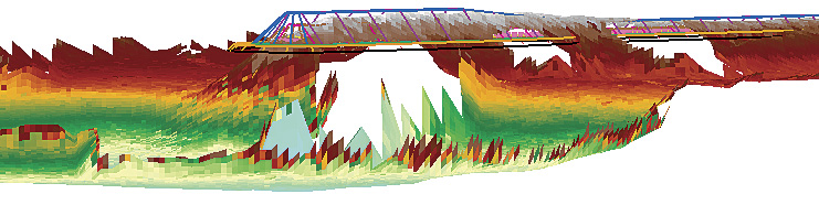
A 3D wireframe representation of a jetty in East Pass, Florida, is combined with survey data showing that the structure has degraded.
Historically, as the Corps districts in these areas collected data for coastal projects, it remained siloed in the confines of the project. "An engineer might not ever know the data she needs already exists, even if she sits five cubicles away from the person who has it," says Rose Dopsovic, eCoastal project manager, U.S. Army Corps of Engineers, Mobile District, Spatial Data Branch.
To improve data sharing and acquisition, the Mobile District developed the eCoastal program-the letter e stands for enterprise. It focuses on optimizing data access in each district, preferably in a geodatabase. The program utilizes Corps spatial data standards and implements national policy to provide a customized framework for spatial data standards, geodatabase structure, and ArcGIS software-based GIS applications that supports the development of enterprise GIS in and across coastal divisions.
"Now, regardless of which project data was collected for, if it's indexed and archived properly, anybody who's interested in the data can find it and apply it to his own project," says Dopsovic. "We tried to put together a standardized architecture to allow people to find the data they need-even if they didn't pay for it themselves."
The program also addresses the requirements of districts that don't have GIS experts in-house. It gives districts the analytic tools, lessons learned, and data structure they need to effectively use their geospatial information.
Coastal Customization
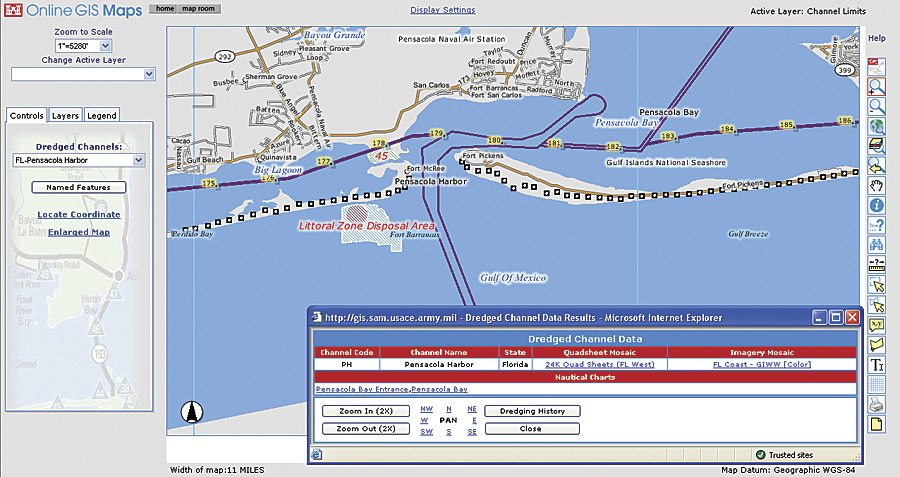
The eCoastal Online Map Viewer allows Corps engineers to select a navigation channel and view dredged channel information, including historical data.
Generally, Corps engineers use the Department of Defense's spatial data standard, known as the Spatial Data Standard for Facilities, Infrastructure, and Environment (SDSFIE). The standard includes hundreds of data models, but only a few are relevant to coastal engineers. To make it easier for coastal engineers to access the models they use, the eCoastal program isolates the pertinent portions.
The Mobile District also requested changes to the Spatial Data Standards committee. For example, coastal engineers need to include the intricacies of CAD drawings in GIS. Historically, a coastal structure would look like a simple line in a GIS. The data model now supports integration of those drawings, giving engineers geometry that accurately represents coastal structures so they can analyze them effectively.
In addition to providing data models, eCoastal includes a suite of custom tools. For example, the eCoastal Datapicker tool allows a user to easily find and connect to needed data. With the ArcGIS Desktop software-based tool, users can search by keyword or category, then load data directly from their own or other Corps districts.
The Coastal Structures Condition Assessment (CoSCA) tool, developed by the Mobile District and the Corps's Engineering Research and Development Center's Navigation Research and Development Program, allows users to make 3D models of structures, such as jetties. A 3D CAD drawing is overlaid on survey data to calculate composition of and damage to structures. Then, engineers can calculate repair costs.
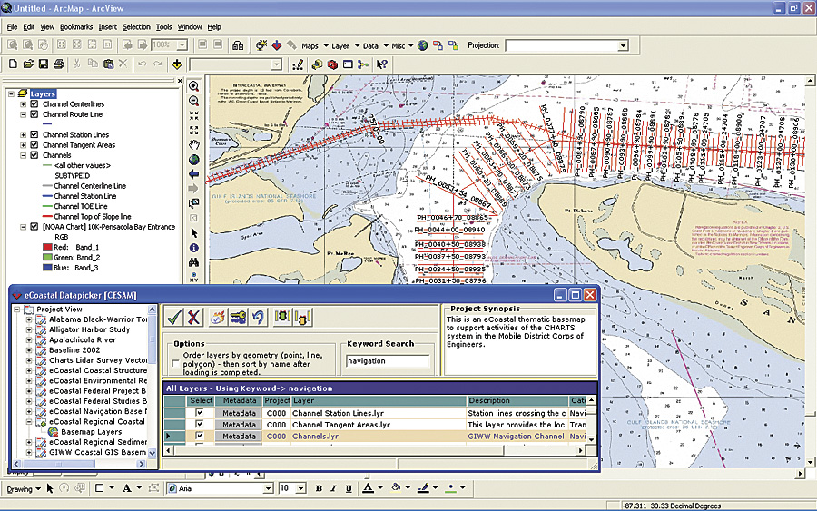
The eCoastal Datapicker tool allows users to easily search a Corps district for data and related metadata.
The Mobile District freely shares the eCoastal documentation and source code with other districts, as well as entities outside the Corps, such as the Florida Department of Environmental Protection, universities, and the public. Much of the complimentary material is available on the Web site at ecoastal.usace.army.mil. However, if an organization would like help setting up its GIS, it can access experts from the Mobile District.
Many districts are taking advantage of this program, adopting all or part of the suggested framework. Buffalo, New York; San Francisco, California; New Orleans, Louisiana; and Charleston, South Carolina, have implemented the full eCoastal architecture. Those that have implemented some elements of the program include Honolulu, Hawaii; New York, New York; Los Angeles, California; Philadelphia, Pennsylvania; and Jacksonville, Florida.
For more information, contact Clint Padgett, chief, Spatial Data Branch, Operations Division, U.S. Army Corps of Engineers, Mobile District (e-mail: Clint.Padgett@usace.army.mil).