Esri Empowers SharePoint Users with ArcGIS Mapping
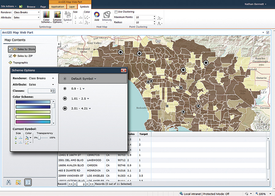
Map symbology can be easily modified to help reveal patterns and relationships within the data.
ArcGIS Mapping for SharePoint enables Microsoft SharePoint users to add maps and GIS analytic tools to their SharePoint content. ArcGIS Mapping for SharePoint works with SharePoint 2010 and allows administrators to quickly add rich, interactive mapping capabilities with which SharePoint users can share maps and tools.
GIS Applications Transcend Department Silos
GIS departments can share their work by delivering maps and GIS analytic tools within SharePoint for use throughout the organization. An organization that uses SharePoint to track and share performance metrics, such as a retail enterprise investigating sales by region or store, can display those statistics graphically on a map. Symbology can be selected to display each store as a low-, medium-, or high-performing location based on preselected values. This mapped data reveals patterns and trends not visible in tabular data, making it a powerful but easy-to-use analytic tool. For example, a map may reveal where stores are competing with one another, negatively impacting sales for both locations. Another map might expose where a business' best customers exist and identify other locations to reach similar demographic markets.
Executives can now independently access mapping tools and perform advanced analysis on their data in SharePoint, gaining greater insight into their businesses. A common, shareable view enables widespread efficiencies and successful collaboration, as users access existing maps, workflows, and content in their individual projects, then share them with the enterprise.
Empowering SharePoint users to create their own maps reduces demands on an organization's GIS professionals while increasing the opportunity to benefit from enterprise-wide use of mapping. ArcGIS Mapping for SharePoint includes tools that enable SharePoint users to create revealing maps, such as heat maps, that can be used for actionable results.
Lightweight, Extensible Framework
Built on ArcGIS API for Microsoft Silverlight/Windows Presentation Foundation (WPF), extensions can be developed through an included flexible extensibility API. This allows developers to create Silverlight extensions to interact with the map, display other content inside the Web part, and communicate with Web services and other external components.
ArcGIS users can now bring the advanced spatial analysis capabilities of their existing geoprocessing workflows and tools to SharePoint. Geoprocessing services allow the automation of repetitive GIS tasks that may be simple or complex, such as buffering features on a map. The real strength of geoprocessing services is their ability to perform advanced spatial analysis in an efficient way. The ability to deliver ArcGIS geoprocessing services in SharePoint allows non-GIS users throughout the organization to more thoroughly analyze their data.
ArcGIS Mapping for SharePoint includes a basemap gallery that provides a variety of map types—aerial, topographic, street, and hybrid—so the most effective type of map for a project is readily available. Additionally, an easy-to-use interface with ArcGIS.com allows users to search for, describe, save, or create a map.
ArcGIS Mapping for SharePoint is available as a download and is easy to deploy to a SharePoint installation. To download ArcGIS Mapping for SharePoint or to get more information, visit esri.com/sharepoint.