Providing Building Blocks for Haiti Reconstruction
The Salvation Army Brings GIS into the Streets to Plan Transitional Shelters
Highlights
- Using ArcPad, the data is captured and can be edited and displayed while out in the field.
- The team performs a damage risk assessment once data from field assessments is compiled.
- Maps and reports created from this information are shared throughout the Salvation Army and with other NGO staff.
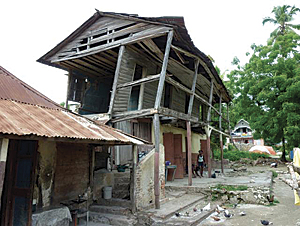
![]() Headquartered in London, England, the Salvation Army was founded in 1865 and is known for its charitable work in more than 121 countries. Providing humanitarian aid beginning with emergency response, the organization was one of the first responders to the magnitude 7.0 earthquake that rocked Port-au-Prince, the capital of Haiti, on January 12, 2010. The earthquake caused major destruction to buildings and extensive loss of life. Salvation Army property in the city was severely damaged, including a children's home and the divisional headquarters. This did not stop personnel from responding immediately; the organization's administrative compound was used as an Emergency Operations Center, with people sleeping in the parking lot.
Headquartered in London, England, the Salvation Army was founded in 1865 and is known for its charitable work in more than 121 countries. Providing humanitarian aid beginning with emergency response, the organization was one of the first responders to the magnitude 7.0 earthquake that rocked Port-au-Prince, the capital of Haiti, on January 12, 2010. The earthquake caused major destruction to buildings and extensive loss of life. Salvation Army property in the city was severely damaged, including a children's home and the divisional headquarters. This did not stop personnel from responding immediately; the organization's administrative compound was used as an Emergency Operations Center, with people sleeping in the parking lot.
Today, the Salvation Army serves as a UN-designated "lead agency" for approximately 20,000 Haitians who are living in tents within a soccer stadium near the organization's Port-au-Prince headquarters. The Salvation Army is making it a priority to transition refugees from this camp into temporary shelters and has established a New Recovery and Development Office in Haiti, hoping to better match international assistance with local need. This office will continue the work the planning group of the Salvation Army World Service Office Incident Management team has been doing for the past eight months. GIS has been a main tool used to ensure that the transitional shelters are built.
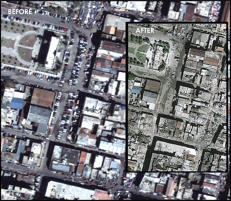
The 7.0 earthquake that rocked Port-au-Prince on January 12, 2010, caused major destruction to buildings, as seen in these before and after images.
This team began a Haiti Earthquake Transitional Shelter project to assess the need for shelter around the area of Jacmel, a city on the Caribbean coast in southeast Haiti, about 86 kilometers south of Port-au-Prince. Jacmel serves as the capital city of the southeast department, one of 10 in the country.
In March of this year, the team completed a 12-day shelter site assessment, logging 400 assessments in the townships of Jacmel, Cay Jacmel, Bainet, and Decouze. Later, in May, the planning group returned to the country to begin construction of the shelters. This fall, the group returned once again to complete construction of 1,500 more temporary shelters.
Using GIS on the Ground for Disaster Relief
A significant aspect of the field assessment was to accurately map and record shelter site locations. The team used high-performance GeoXT/Nomad Trimble data collectors combined with ArcPad to digitally record transitional shelter site locations. Assessment teams have two members: an interpreter and an interviewer.
The interpreter records the GPS location of the home site and photographs the people present, as well as the home, to assess condition and need. The interviewer obtains host family information, such as who the owner is; the number of people present; and demographics, including whether amputees or single women live at the home site. Other important information the team captures is the distance to freshwater sources and latrines. This data helps disaster recovery unit members decide which site to attend to first.
"The teams were effective in gathering information because they successfully established key relationships with community leaders, kazaks, and other humanitarian aid workers," says Finn Dahl, GIS director at DES, Inc. Dahl is responsible for managing GIS operations in Haiti for the Salvation Army Transitional Shelter Project.
Using ArcPad, the data is captured and can be edited and displayed while out in the field. The data from these field assessments, along with other GIS data layers, is then compiled using ArcGIS in the evenings back in a makeshift office. From this, the team performs a damage risk assessment. Homesteads that belong to women with young children and structures that have sustained significant damage and either no longer exist or are dangerous to inhabit are put at the top of the list. Maps and reports created from this information are shared throughout the Salvation Army and with other NGO staff to plan shelter construction.
Colorado Pine in Haiti
Construction began in May with lodgepole pinewood from the Colorado forests. The lumber has been milled by Intermountain Resources, LLC, in Montrose, Colorado, from trees killed by the mountain pine beetle. The beetle is the size of a grain of rice and affects trees in northern and central Colorado. As long as the tree that has been affected is cut down within 8 to 10 months of dying, the wood's integrity is preserved, and it is structurally sound. Using this lumber provides an environmentally conscious solution for the use of the wood, and milling it has opened up job opportunities in the state of Colorado.
The earthquake severely damaged property in Port-au-Prince.
The transitional shelters are composed of two rooms, house five people, and are able to withstand winds of up to 30 miles per hour. Raised wooden floors prevent Haitians from risking disease by using water flowing through their homes for hygiene or cooking. In many instances, these homes provide a safer and more structurally sound environment than has been available traditionally to the people in Haiti.
The Salvation Army trains crews and hires local workers in Haiti to construct the shelters, which not only creates jobs through cash-for-work programs but also provides technical skills, such as carpentry, for Haitians to use in future construction projects.
Lyle Laverty, a volunteer with the Salvation Army and former assistant secretary of the interior for Fish, Wildlife and Parks, along with a technical working group, designed the frame specifications and a proposal for what the shelter should look like, as well as what construction materials were needed.
A model was built in one day and used to demonstrate the construction process to U.S. Agency for International Development (USAID). It is hoped that construction of transitional housing will be complete by the end of the year. This is an optimistic goal, as almost the whole city of Port-au-Prince has been demolished, and many estimate it will take a year just to clear the rubble.
Viewing Field Data in the Home Office—in Real Time
This fall, the team will be bringing some heavy GIS artillery out into the field—many licenses of GIS software that will send data as it is collected to those who need it, all over the world. The Salvation Army is using BlackBerry devices donated by Research in Motion—a company based out of Ontario, Canada, that designed and manufactures the BlackBerry smartphone—to provide the mobile access necessary to publish GIS data directly from the field. Working in concert with the Trimble devices, the smartphones are equipped with Freeance, a Web mapping application from Dayton, Ohio, Esri partner TDC Group, Inc.
Freeance allows the assessment teams to work directly with those not out in the field by making the GIS data available to everyone, regardless of their location. Assessment team members use their BlackBerry handsets to browse their local GIS data stored on ArcGIS Server, as well as reading and writing to custom forms that have been created. Freeance Mobile uses GPS location to ensure that the data position is accurate. GIS applications display live data on a map as the data is logged by the assessment teams, displaying live map features and the location of field crews and providing users with the ability to search records created in the field.
Dahl created a Web-based Silverlight application using the ArcGIS API for Microsoft Silverlight to ensure that people can easily browse the data that is collected and to save money and time by providing the data online instead of relying on printed maps to convey information. "This provides the transparency that countries need to ensure that the donation monies provided are put to good use," says Dahl.
Providing Transparency from the Ground Up
Transparency is an important issue in the United Nations and its umbrella organization, the International Organization of Supreme Audit Institutions (INTOSAI). INTOSAI, based in Vienna, Austria, is an autonomous and nonpolitical organization that works with the United Nations Economic and Social Council (ECOSOC) to set forth policy recommendations for promoting higher standards of living around the world.
"Our study on transparency, accountability, and the audit of the tsunami-related aid in Indonesia made us realize that there is added value in using geospatial data for the planning, coordination, monitoring, accountability, and audit of disaster-related aid," says Egbert Jogsma, Netherlands Court of Audit. "INTOSAI concluded that, in order to ensure long-term accountability and transparency, geospatial data should be immediately included in the information structure of agencies involved in the reconstruction of Haiti."
The Salvation Army is taking advantage of Esri's Nonprofit Organization Program, which is designed to bring humanitarian organizations an affordable means of acquiring ArcGIS software and services. "Before," adds Jogsma, "the Salvation Army had to rely on consultants to provide it with the necessary GIS software. This program will allow us to build up our capacity around the world and more efficiently share the data we collect with Salvation Army headquarters."
For more information, contact Daniel Starrett, executive director, Salvation Army World Service Office (e-mail: Dan_Starrett@USN.salvationarmy.org).