URISA Proposes a Local Government GIS Capability Maturity Model

"Managing GIS"
A column from Members of the Urban and Regional Information Systems Association
By Greg Babinski, GISP, Finance and Marketing Manager, King County GIS Center
One Saturday shortly after moving into my first house, I awoke to hear a drip, drip, drip sound coming from the bathroom. "Honey," my wife said, "there's a leak in the bathroom sink." "No problem," I replied, even though I had never repaired plumbing before. "I'll git 'er done right after breakfast."
Six hours later, after a bumped head; scraped knuckles; and three trips to the hardware store for tools, fittings, and gaskets, I had "got 'er done." The next time I had a leak, the repair process went much faster, because I applied my previous experience.
Local Government GIS Capability Maturity Model.
I didn't realize it, but I had just progressed through the first two stages of a process capability maturity model (CMM). My first effort was ad hoc and chaotic. I advanced to a repeatable process, recalling and applying steps I had used to fix the problem before.
Homeowners manage complex systems that provide shelter and safety; a means to store and cook food; and a place to rest, socialize, and recreate.
As local government GIS managers, we operate and maintain systems that are more complex than our abodes and represent huge investments supporting a wide range of government business needs. The maturity level of our processes relates directly to the effectiveness of our GIS.
What Is a Capability Maturity Model?
A capability maturity model assesses an organization's ability to accomplish defined tasks. The CMM concept originated with the Software Engineering Institute (SEI), which published Managing the Software Process in 1989 to assess software contractors' ability to successfully complete large software development projects.
The CMM concept has since been applied to system engineering, project management, risk management, and information technology services. A CMM assesses an organization's maturity level based on how it executes individual processes. The maturity levels are usually defined as
- Level 1: Ad hoc (chaotic) process
- Level 2: Repeatable process—Based on the previous successful methodology
- Level 3: Defined process—Successful processes documented to guide consistent performance
- Level 4: Managed process—Documented processes measured and analyzed
- Level 5: Optimized process—Defined and managed processes refined by ongoing process improvement activities
GIS Development Life Cycle: When Is GIS "Complete"?
GIS development ideally progresses toward full maturity. Often begun as a project to create the "best GIS possible" with limited funds, GIS program development involves frequent compromises. Components of an ideal GIS program are often deferred to go operational quickly and start delivering return on investment (ROI) for the agency. The end of a GIS implementation project does not mean that the agency has a complete or mature GIS.
Managers usually know their GIS could benefit from refinement, but funds, staff, or time for further development are difficult to acquire. Enhancements may be developed as part of GIS operations but rarely on a systematic basis with a desired end goal.
GIS Benchmarking Studies and Maturity Assessments
Benchmarking studies compare an agency's GIS with other peer organizations. They can identify industry best practices, resource and service-level imbalances, and process improvement areas. Because of the significant time and cost required, benchmarking studies are rare.
Maturity assessments are not well developed within the realm of local government GIS, but the National States Geographic Information Council (NSGIC) is developing a statewide Geospatial Maturity Assessment (GMA).
Why Develop a Local Government GIS Capability Maturity Model?
An old management adage states, "You can't manage what you don't measure."
For any local government GIS program, ROI increases as the process capability maturity level of the GIS staff increases. If we accept this hypothesis, a GIS CMM can provide an indication of the ability of local agencies to realize the potential benefits from their GIS investments.
Many of the processes that have had the CMM approach applied in the past are themselves components of GIS. It is useful to think about a GIS operation in theoretical terms, then analyze and measure individual GIS operations against this ideal end state. A GIS CMM allows local GIS operations to gauge their capability and maturity levels against a variety of measures, including
- A theoretical end state of GIS data, hardware, and software infrastructure
- A theoretical end state of GIS organizational development
- The maturity level of other peer GIS organizations, either individually or collectively
- The maturity level of the subject organization over time
- The maturity level of the organization against an agreed target
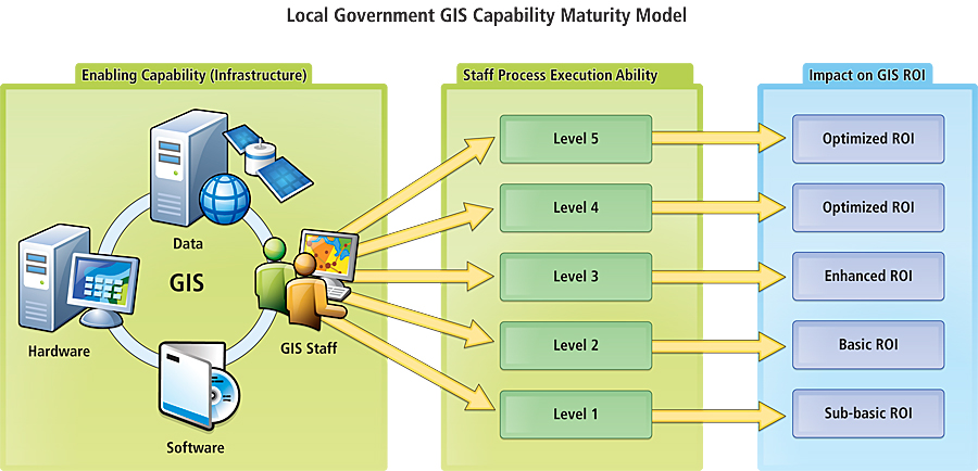
URISA's Proposed Local Government GIS Capability Maturity Model
URISA's proposed model indicates progress by an organization toward GIS capability that maximizes the potential for the use of state-of-the-art GIS technology, commonly recognized quality data, and organizational best practices appropriate for local agency business use. The URISA GIS CMM assumes two broad areas of GIS development: enabling capability and process execution ability.
The GIS CMM assumes that mature agencies have well-developed enabling technology and resources and that their processes maximize the effectiveness of their GIS infrastructure. Enabling capability includes technology components, data, professional GIS staff, organizational structure, and other resources and infrastructure. Execution ability is the competence of the staff to use the available capability and provides an indication of the potential for increased ROI.
The enabling capability assessment includes 21 components with a scale modeled after the NSGIC GMA. Because GIS-enabling capability is dependent on resource availability, the GMA scale (with its resource-commitment focus) is well suited to indicate capability.
The execution ability assessment includes 14 components and is modeled after the typical CMM process-based, five-level scale. Because the execution ability of a GIS depends on its process performance, the typical CMM assessment scale (with its focus on process execution) is well adapted to measure ability.
Current Activity and Next Steps
URISA's draft GIS CMM was completed in 2009 by 12 counties and 19 cities in Washington state. Results were presented at the 2009 URISA Annual Conference and at GIS conferences in Oregon and Washington in 2010. A three-hour GIS CMM workshop was held at GIS-Pro 2010 in Orlando, Florida. Feedback has been solicited and agencies invited to complete the assessment to expand the base of knowledge about the maturity level of local government GIS.
NSGIC has been informed of GIS CMM development, and there is interest in utilizing local agency GIS CMM assessments to inform state-level GMAs. The GIS CMM was presented to the National Geospatial Advisory Committee (NGAC) in Washington, D.C., in September 2010. NGAC is interested in the development of metrics for the National Spatial Data Infrastructure (NSDI) and sees potential for the GIS CMM, the GMA, and the Coalition of Geospatial Organizations' (COGO) proposed National Geospatial Technology Report Card to provide the means for measuring development of the NSDI.
The URISA Board has indicated its support of further development of the GIS CMM. Future refinement of the model itself and a means of institutionalizing the model are needed. One suggestion is to use an approach similar to the Green Building Council's LEED Certification program. For the GIS CMM, this might mean the submission by local agencies of a portfolio with the self-assessment for a peer-based review process to certify an agency's maturity level.
URISA is currently considering a means of refining the model and developing recommendations for implementing it on a sustainable national basis.
To see the current version of the model, visit tinyurl.com/GISCMM.
About the Author
Greg Babinski, GISP, is the finance and marketing manager for the King County GIS Center in Seattle, Washington, where he has worked since 1998. Previously, he worked for nine years as GIS mapping supervisor for the East Bay Municipal Utility District in Oakland, California. He holds a master's degree in geography from Wayne State University, Detroit, Michigan. Babinski is the president-elect of URISA, to become president in October 2011.
For more information, contact Greg Babinski, GISP, finance and marketing manager, King County GIS Center, and URISA president-elect (tel.: 206-263-3753, e-mail: greg.babinski@kingcounty.gov).