 The Magazine for
Esri Software Users
|
|
|
County Integrates
Property Data and Maps
on the Web
By Michael Wentworth, GIS and Mapping Supervisor
Brevard County Property Appraiser's Office
Brevard County, home of the Kennedy Space Center, is situated on Florida's east coast. The County stretches 72 miles in a north-south direction and covers 22 miles east to west. Located just 40 miles to the east of the Orlando metropolitan area, Brevard County has experienced a steady growth rate of about 3 percent a year. The population now totals nearly 500,000.
Brevard has had an active GIS program since 1988. Like many other GIS programs started in the late 1980s, Brevard's program evolved not only in terms of hardware and software but also in terms of focus. The first four years were spent developing the property parcels base layer. However, those funding the project needed something to show for the money spent, so application and map product production became the primary focus of the program.
Early GIS Development
Most applications added additional layers of information, such as planning, zoning, utilities, street, and resources, to the GIS system or were created in response to specific departmental needs. It became apparent to the GIS staff and to the County property appraiser that a great deal of work was needed to improve the accuracy and quality of the basemaps. In 1995, the GIS program was under the Brevard County Board of County Commissioners. An agreement between the County manager and the property appraiser moved the core GIS staff to the Property Appraiser's Office so efforts could be concentrated on improving the accuracy of the basemap. Since the move, the GIS staff have continually improved the mapping base through the use of GPS technology and COGO and have worked to get GIS information into the hands of the user community.
Initially, efforts to expand the use of GIS were through the development of an ArcInfo program named Mapper that allows staff to easily manipulate GIS property data with other overlay information such as zoning, soils, flood zones, wetlands, and aerial photographs. Written in ARC Macro Language (AML), the program was a success and has been in use for more than two years.
The Brevard County Property Appraiser's Office faced the challenge of disseminating this type of information to the general public. Though a prototype ArcView GIS application was developed for public access, maintenance and training costs were prohibitive given the available budget and staff resources. While this application was being developed, the rise of the Internet pointed the way to a possible solution to this problem.
Developing the Web Site
In mid-1997, the Property Appraiser's Office developed a text-based Web site in conjunction with the Brevard County Library System as a way of disseminating information about the functions of the Property Appraiser's Office. Initially, this consisted of just a few pages of information. Subsequently, a decision was made to purchase a dedicated server and develop a database searching mechanism to provide access to property information for staff and the public. Initial planning focused on the use of the Internet database for typical types of property appraisal analyses. During this phase, the GIS staff contacted several real estate appraisal firms and real estate agencies for their input. Mark Johns, a private sector appraiser who is now an appraisal specialist with the Property Appraiser's Office, was one of those contacted. "What appraisers and real estate professionals need are tools to quickly access and research similar properties," said Johns. "Such a system needs to allow the user many ways at getting to the data."
Funds for a Dell PowerEdge 4200 server were budgeted and a consultant was contracted to develop the database search engine. The consulting firm, Coleman Technologies Inc. (CTI), of Orlando, Florida, was hired because of the firm's previous experience in developing the Orange County, Florida, property appraiser's Web site. By August, the application and server were in place for testing. The existing Web site was transferred to the new server and the database application was installed. After a month of testing and tweaking the site and application, the site was put online to the public.
The database search criteria developed for use on the site are powerful but simple. The site allows for advanced searches of the property database through multiple user-selected parameters. Advanced searches can be made using criteria specific to residential, commercial, and vacant land properties.  Sales analysis of properties using parameters such as use code, year built, and square footage can pinpoint comparative sales. Properties can even be searched for by specific site amenities such as river or golf course frontage. Sales analysis of properties using parameters such as use code, year built, and square footage can pinpoint comparative sales. Properties can even be searched for by specific site amenities such as river or golf course frontage.
The use of drop-down menus throughout the site limits the user's response to correct combinations of input parameters and speeds the query process. Depending upon how frequently item selections are updated, the drop-down selection items are stored either directly in the Active Server Page (ASP) code used throughout the site or in a Microsoft Access database as a separate table.
The interface also uses a disclaimer filter page to ensure that users have seen the data and mapping disclaimer. This also prohibits the user from bookmarking the record search area and bypassing the disclaimer information. This was accomplished by using cookies and setting a time limit for the active user session. While the use of cookies has caused some users to complain, it was necessary to limit exposure to liability.
Mapping Enchancements
Not content to provide the public with database information, Jim Ford, Brevard County's property appraiser, authorized expansion of the Web site capabilities to include a mapping component. "As an elected official, I feel it is my duty to provide the taxpayers of this County with as much information as possible at the least amount of cost to them," stated Ford. "Our Web site allows us to do that at minimal cost to our citizens."
Planning for the mapping enhancement began in November 1998. Since the database application had been completed with more than satisfactory results, CTI was again chosen to develop the mapping interface. Brevard County's GIS program uses ArcInfo in a Sun/UNIX environment. The decision to develop the Internet and mapping application using Esri's MapObjects and Visual Basic meant changing to Microsoft Windows NT platform. This was a major departure from the previously all-UNIX environment and required that staff assigned to the project undergo training and perform additional system integration tasks.
This was CTI's first Web-based mapping application, and it presented the company with unique development challenges in addition to learning MapObjects. Brian Rasche, a software engineer with CTI, integrated the existing data server with the mapping server, which proved to be less of a challenge than originally anticipated. 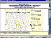 According to Rasche, "Integrating the map server with the data server was the easiest part of the project. The user is simply transferred back and forth using hyperlinks. The trickiest part of the application was being able to generate the map image in the desired target response time of less than three seconds." According to Rasche, "Integrating the map server with the data server was the easiest part of the project. The user is simply transferred back and forth using hyperlinks. The trickiest part of the application was being able to generate the map image in the desired target response time of less than three seconds."
Interface Design
Much time and effort was put into the design of the mapping interface. It was a collaborative effort between the Property Appraiser's GIS and Mapping Supervisor, the Property Appraiser, the Property Appraiser's Chief Deputy, and CTI. Bits and pieces from other property-related Web mapping sites were incorporated in the design. The resulting mapping application interface uses Web frames. The top frame is the page title and navigation bar. The middle frame contains the mapping application. The bottom frame displays query results. Though the size of each frame is determined as a percentage of the user's total screen size in pixels, the display was optimized for an 800 by 600 pixel screen resolution.
In keeping with the look and feel of the database application, the mapping application employs drop-down selection lists. This allows many selection criteria to be placed in a relatively limited screen area. Users can just click on the Brevard County map and instantly zoom to an area of interest, or they can select by parcel ID, name, address, or tax account number fields. The type of information displayed in the query results frame is controlled by a drop-down selection that presents various parcel information summaries. Another drop-down list allows users to instantly zoom to cities or other familiar areas of the County by selecting a named area. The x,y coordinates for the map extents for named areas are stored in an Access database. In response to a query, the coordinates for the appropriate area are retrieved and graphically displayed in the mapping frame.
A mapping server was included in the operating budget, but hardware specifics had not been fully studied when application development began. Based on the advice from Esri staff and other agencies that had implemented MapObjects applications, a second server was configured to handle the map requests. A Dell Windows NT-based server with 1 GB of RAM, two Pentium III 500 MHz processors, and an enhanced graphics accelerator card was ordered.
A prototype mapping interface was in place and being tested on a developmental server at CTI headquarters in Orlando by the end of May 1999. Several map-related concerns had to be resolved before the application was introduced to the public. The application uses a shapefile that combines all the GIS section maps. Brevard County originally digitized each section separately and was in the middle of a map enhancement and edgematching program. Consequently, many maps did not line up with adjacent maps. "The Web made us acutely aware of some of the areas that needed our immediate attention," stated Dave Jordan, the senior GIS analyst assigned to oversee the correction tasks. The worst areas of overlap and misalignment were targeted for rapid adjustment before release to the public. A concentrated effort by all GIS staff from June through July 1999 corrected these problem areas.
A decision regarding the type of information that should be available to the public was needed. Initially, the site would include not only property data but a wide range of overlay information such as soils, zoning, and wetlands. While these layers could be displayed, possible errors in map interpretation and digital misalignments might lead the public to draw erroneous conclusions about individual parcels. As a result, only property and physically locatable information was included in the final release.
Public Reaction
The site went online on August 22, 1999. The mapping Web site enhancement was available just in time for the annual Truth in Millage (TRIM) notice mailing that had a section devoted to the new Web site features. Response from the public has been very positive, and the site now records approximately 30,000 hits a day and over 4,000 maps are served each day.
The mapping enhancement added a new dimension to the Web site. Now users can access any property in Brevard County through a database query or directly on the mapping interface. Users can view property information and perform radius analysis from a chosen point. Sales analysis queries performed on the database server can be automatically displayed on the map.
Eventually, additional layers of information will be incorporated into the Web-mapping site. Work continues on addressing problems caused by map misalignment. A derivative version of the existing mapping functions will be developed for internal Intranet usage. This version will incorporate the layers available in GIS that affect property valuations such as zoning, future land use, soils, and flood zones.
The goal of the project�to allow public access to the Property Appraiser's records and maps--has been realized through this technology. The Web has provided the means to finally get GIS data into the hands of users in a simple and affordable interface.
The Brevard County Property Appraiser's Web site can be accessed at www.appraiser.co.brevard.fl.us.
 For more information, please contact
Michael Wentworth
E-mail: mike.wentworth@brevardpropertyappraiser.com
Tel.: 407-264-6957
About the Author
Michael Wentworth, GIS and mapping supervisor for the Brevard County Property Appraiser's Office, has been involved in the planning, development, and implementation of GIS systems in Brevard County since 1985. He has a master's degree in computer resources and information management from Webster University and a bachelor's degree in geography from the University of Florida. His professional interests include Web development and computer systems analysis.
| |
