 The Magazine for
Esri Software Users
|
|
|
Fire Hydrant Maintenance
Using GPS and GIS
By David Allen,
GIS Manager
City of Euless, Texas
Editor's Note: A joint project developed by the Fire Department and GIS staff of the City of Euless, Texas, leverages existing GIS data and GPS technology to benefit both groups as well as other City departments. Euless, a midsize city with a population of 44,000, is located midway between Dallas and Fort Worth.
Fire hydrant maintenance is a chore performed by the Fire Department. Firefighters visit each hydrant in the City to check its general condition. Sometimes they trim the weeds, grease the caps, or exercise the valve. However, because not all of the hydrants appear on the map, and not every hydrant is correctly located, the real purpose of this exercise is to familiarize firefighters with hydrant locations.
To improve incident reporting and computerize response preplanning, the Fire Department acquired a new management software called Firehouse. This software allows external data to be imported. Address data that had been tested and used by the City's GIS Department for the last 10 years was imported into Firehouse. Addresses for all of the City's homes and businesses were now available from a pick list on the incident report screen.
Next the Fire Department requested fire hydrant data, specifically a unique identifier and latitude/longitude coordinates for each hydrant. Before the GIS staff members imported anything into Firehouse, they wanted to perform an inventory to account for all hydrants. Since identifying and locating hydrants would be a lot of work, the staff decided to collect additional information on hydrant condition and manufacture date.
 Coincidentally, the GIS Department had acquired a GPS system for use in a utility collection project. The plan was to collect location data for visible features of the water, wastewater, and storm drain systems. The system, made by Tripod Data Systems, allows collection interface customization and uses built-in virtual reference station technology for on-the-fly data correction that gives real-time differentially corrected GPS readings accurate to one meter. This lightweight system is fully inclusive on the range pole and requires no backpack or bellybag. Coincidentally, the GIS Department had acquired a GPS system for use in a utility collection project. The plan was to collect location data for visible features of the water, wastewater, and storm drain systems. The system, made by Tripod Data Systems, allows collection interface customization and uses built-in virtual reference station technology for on-the-fly data correction that gives real-time differentially corrected GPS readings accurate to one meter. This lightweight system is fully inclusive on the range pole and requires no backpack or bellybag.
Cooperation Pays Off
While considering how to implement both the hydrant and the utility project, the GIS staff realized that fire hydrants are visible features of the water system. The GIS staff realized that firefighters could use the GPS receiver purchased for the utility project to collect latitude/longitude coordinates and other hydrant features. However, there were a whole host of fields in the Firehouse database that the Fire Department wanted to populate. Inputting data for all these fields would be far too much for a firefighter standing in the hot sun.
This was when the spirit of cooperative effort paid off. If the firefighters collected some data in the field, the GIS staff would populate the remaining Firehouse fields using information available from the water system map. 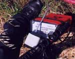 The field data to be collected included year of manufacture (which is cast into the side of the hydrant's base), make; general condition, the name of the street the hydrant faced, a memo describing what maintenance was performed, verification that the blue reflector was correctly placed in the street; and (of course) the location of the hydrant captured using the GPS unit. Firefighters would also rivet a metal tag stamped with the hydrant's unique identifier to the barrel of the hydrant. The field data to be collected included year of manufacture (which is cast into the side of the hydrant's base), make; general condition, the name of the street the hydrant faced, a memo describing what maintenance was performed, verification that the blue reflector was correctly placed in the street; and (of course) the location of the hydrant captured using the GPS unit. Firefighters would also rivet a metal tag stamped with the hydrant's unique identifier to the barrel of the hydrant.
Training the Fire Department staff to use the GPS proved to be extremely simple. The original plan was to team firefighters with the GIS staff for the first day and supply follow-up training as needed. After collecting data at three or four hydrants, the firefighters were comfortable using the system and needed no further training.
Combining the hydrant attribute data collected in the field with additional data that existed in the GIS, and the water system map data, supplied all the desired information. The hydrant information now included a unique ID, a street address, size of the feeder main, fire response zone, hydrant model, fire district, nearest station, and the latitude/longitude translated from the State Plane coordinate system. In all, 18 fields were populated and transferred to Firehouse.
Added Benefits
Not only was useful data added to the Fire Department's software but the GPS location of the hydrant helped increase the accuracy of the water map. New hydrants were added, bogus hydrants were removed, and most of the other hydrants were shifted slightly to correctly represent their true location. The same procedure will be performed on the valves to increase the accuracy of the City's water maps. New hydrants were added, bogus hydrants were removed, and most of the other hydrants were shifted slightly to correctly represent their true location. The same procedure will be performed on the valves to increase the accuracy of the City's water maps.
In addition to these benefits, the project has the potential to help in other ways.
- The Public Works Department describes the location of hydrants that are being taken out of service for water line repairs to police and fire dispatchers. Prior to the hydrant survey these descriptions were often limited to "the one in front of the third house on the left north of the intersection." Dispatch was often confused about exactly which hydrant was out of service. Now hydrants are referenced by the unique identifier. It is clear which hydrant is down.
- The Public Works Department is also using ArcExplorer to look up hydrant ID numbers by street address or graphic selection. This test project lets staff identify hydrants that require maintenance that the Fire Department would not normally perform.
- The latitude/longitude coordinates for locations in the City can quickly be approximated based on the nearest hydrant. The Fire Department may provide hydrant coordinates to the Care Flight helicopter ambulance so that it can find locations more quickly.
About half of the City has been inventoried. The full value of the project has yet to be realized, but the payoff is already apparent and the future can only bring more benefits. Next, the GIS staff will coordinate with the Public Works Department to collect location points for the remainder of the visible features of the water system, the sewer system, and finally the storm drains. The firefighters will wrap up their project soon and are searching for additional uses for GPS. Actually they just had too much fun playing with this cool new technology!
For more information, please contact
David Allen
GIS Manager, City of Euless
201 N. Ector Drive
Euless, Texas 76039
E-mail: dallen@ci.euless.tx.us
Special Thanks
The author thanks Matt Lehman of Tripod Data Systems for the use of a GPS unit during his Esri user conference presentation. Thanks also go to Chief Kountz and Scott Parsley of the Euless Fire Department for their help in making this project a reality and to Dan McLean, manager of information services, for prying free the money to purchase the GPS receiver in the first place!
| |
