|
GIS-Based Warning System Keeps Business on Track
By Clive F. Reece, Doug P. Chenevert, and Greg C. Liknes, DTN Weather Services
All modes of transportation--plane, train, automobile, or ship--can be adversely affected by weather conditions. For railroads, weather-related derailments can result in injury or death to workers, destroy tracks, and cause losses that range from tens of thousands to millions of dollars. The ability to briefly delay trains threatened by weather events can minimize hazard and loss. A weather-related accident involving a moving train can be 10 times more costly than one involving a stationary train.
| |
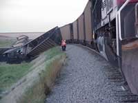
Delaying trains briefly can limit hazards and damage.
|
|
|
The Union Pacific Railroad (UPR), the largest railroad in North America, operates 6,847 locomotives and manages 38,654 miles of track in 23 states. UPR links every major West Coast and Gulf Coast port, serves four major gateways to the east, and is the primary rail connection between the United States and Mexico and interchanges traffic with the Canadian rail system.
To keep down costs and protect people and property from weather-related train accidents, UPR needed reliable, reasonably priced weather data that covered its vast area of operation. UPR also needed to be able to focus on specific locations and weather events. Decisions to stop or delay trains require real-time weather information and the ability to determine the proximity of weather events to track segments and rail cars. A GIS-based system that processed this type of weather information could fulfill many of UPR's needs.
Developing a Solution
DTN Weather Services, a division of Data Transmission Network, is the world's leading supplier of weather solutions, providing GIS-ready data, forecast services, accurate real-time weather, and display systems to more than 20,000 customers. In 2000, DTN Weather Services, an Esri business partner, offered customers the ability to convert up-to-the-minute weather information directly into Esri GIS formats on-the-fly using MetWork-GIS FileServer. The MetWork-GIS FileServer is a weather data ingest and file management system that runs on Windows NT. It supports standard Internet communications protocol and various network configurations.
Using MetWork-GIS and ArcView GIS 3.2, DTN Weather Services created a custom GIS-based track-warning network, the Union Pacific Railroad Weather Alert Notification (UPWAN) system, that helps UPR protect its employees from injury and its equipment from damage while ensuring timely service to its customers.
"I worked very closely with the DTN development team during every stage of the process," said Kevin Crowe, manager of Systems Development and Support at UPR's Harriman Dispatch Center. "They listened to what we had to say and incorporated it into the design. The end result was a product that not only matched our current needs, but also will grow and expand with Union Pacific. We recently had a situation in Oklahoma where DTN alerted us to approaching high winds. The dispatcher stopped the train, and a short time later we received notice that 21 of the cars had blown over and were lying on their sides. If the train had been moving, the loss would have approached $1,000,000 and the track itself would have sustained severe damage. Because the dispatcher was alerted in time, the track was still usable and the overall damage was minimal."
With DTN GIS-based weather data, UPR can monitor specific geographic locations for important weather conditions. When very exact, predetermined weather conditions take place on a particular section of track, the dispatcher responsible receives an immediate, fully automated alert. The dispatcher must then acknowledge that alert within a short time or the alert moves to the next stage. At that stage, the supervisor on duty is notified. Ultimately the system can be shut down. Such steps may sound drastic, but winds, torrential rains, flash floods, and tornadoes can cause significant damage, delays, injuries, and even deaths. These hazards can all be minimized or even eliminated with advanced warning. The networked PC-based system can accommodate more than 100 separate users with text and imagery to monitor the entire UPR system. The data can also be archived for a permanent record for future review or reports.
Design Issues
The time available to dispatchers for evaluating weather data is limited. Consequently, it is best to alert them only to weather events that are relevant to the track segments they are responsible for rather than having them extract information from a large volume of data covering a large geographic extent. In other words, a system was required that provided only information about threatening weather conditions relevant to specific geographic areas, and one that provided this information in a timely and reliable fashion. The system should generate proactive alerts for decision makers (i.e., push rather than pull data) and respond to industry-specific threshold weather events.
| |
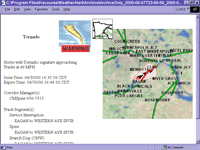
UPWAN provides advanced warning of severe weather conditions.
|
|
|
Stopping trains before a weather-induced accident occurs is the primary goal of the UPWAN system. The specific weather events that threaten trains fall into three main categories: conditions that produce high winds, inundation of a track segment with water, and temperature extremes that could expand or contract rails causing them to warp. After identifying the types of events that create these threatening conditions, UPR outlined the following specific criteria for generating an alert message.
- A tornado warning, flash flood warning, or severe thunderstorm warning issued by the National Weather Service
- Temperatures lower than 0º F or higher than 105º F
- Wind speeds in excess of 50 miles per hour
- The presence of a tornadic vortex signature identified by National Weather Service Doppler Weather Radar (NEXRAD) that is likely to impact a Union Pacific track within seven minutes
UPWAN System Description
The UPWAN system makes use of DTN Weather Services' extensive access to real-time weather sources and experience in graphical analysis of geographic data and processing of weather-related data. Weather information is processed at DTN Weather Services' headquarters in Burnsville, Minnesota. Dispatchers located in offices throughout the Union Pacific network receive weather alerts that are produced by DTN Weather Services.
Use of commercial, off-the-shelf (COTS) software is a cost-saving alternative to proprietary software. Using COTS software can drastically accelerate the development/test cycle by saving time. However, it is often difficult to find COTS software that will provide the exact functionality a project requires or it may be difficult to integrate the COTS software with existing proprietary hardware or software. Both COTS and proprietary software are used in the UPWAN system. The UPWAN design solution required three main components: MetWork-GIS FileServer, ArcView GIS 3.2, and Microsoft Message Queue Server (MSMQ).
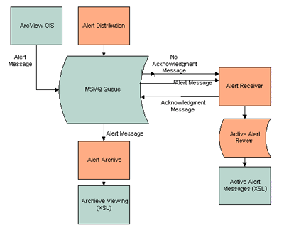
Figure 1: The UPWAN System
MetWork-GIS FileServer
Weather data is brought into the UPWAN system by MetWork-GIS via an I960 card and satellite downlink. Each time new data arrives, a request table is queried to see if any MetWork-GIS clients have requested that data. If so, information about the data is passed to the GIS-Convert Server that formats the data in an Esri-compatible format (in this case, a shapefile).
ArcView GIS
ArcView GIS is used as the GIS-processing engine. Avenue scripts process the shapefile-formatted weather data on the MetWork-GIS FileServer. Shapefiles containing weather data are queried for the UPR-defined threshold weather events. The resulting selection is intersected with a UPR track buffer polygon so that significant weather events that fall within a specified distance of a track can be identified. With respect to the integration of ArcView GIS with other UPWAN system components, COM interfaces cannot be called directly from ArcView GIS. However, DLL-resident exported functions can be accessed using Avenue. By calling DLL functions, ArcView GIS generates and sends XML messages.
Microsoft Message Queue Server
MSMQ routes messages from the server in Burnsville to the dispatchers distributed throughout the country. MSMQ is a store-and-forward service that is freely available to licensed Windows NT server users in the Windows NT Option Pack. The server in Burnsville is set up as a Primary Site Controller (PSC) and a computer in Omaha serves as the Primary Enterprise Controller (PEC). Dispatcher desks are connected via a LAN to the PEC and are configured as independent clients in the MSMQ enterprise.
Software that exploits MSMQ capabilities was developed specifically for UPWAN. Figure 1 shows the relationships between the components listed below.
- Alert Distribution
- This component accepts notification messages from Avenue scripts and passes them along to the Alert Presentation component via MSMQ. It also monitors the dispatcher's acknowledgment, and escalates the notification if no acknowledgment is received. All notifications, acknowledgments, and failures to acknowledge are logged via MSMQ journals.
- Alert Receiver
- When the notification message arrives at the dispatcher's desk, this component initiates an on-screen dialog for the dispatcher's acknowledgment. The same component is also used for notification messages to the other users (i.e., the Dispatch Corridor Manager and the Service Interruption desks). This notification includes both the original alert message and, for the Service Interruption desk, the nonacknowledgment notification message. Alert Presentation also saves the notification data locally as long as the alert is active, so it is available for further review.
- Active Alert Review
- After closing the initial notification dialogs, the end user sometimes needs another look at the weather problem. Active Alert Review allows the user to view currently active messages saved locally by Alert Receiver. It is implemented as an eXtensible Stylesheet Language (XSL) style sheet.
- Alert Archive
- Periodically, the logged messages in the MSMQ journals must be archived to disk files and deleted from the journals. The disk files allow review of the historical alert message activity and can be saved on removable storage media if necessary. The Alert Archive can also be used to generate an archive image without deleting the messages from the MSMQ journals.
Reusability of System Components
The idea of weather alert notifications is a logical extension of DTN Weather Services' current business. With this in mind, the design of the system should facilitate the reuse of components as much as possible. DTN Weather analyzed which system requirements would likely be common to similar installations versus the unique requirements of specific customers (or types of customers) that would necessitate customization.
Figure 2: Characteristics Affecting Reuse of UPWAN Components
| Common Characteristics | Unique Characteristics |
| Geographic analysis of affected areas | Specific threshold values for determining significant weather events |
| Significant weather thresholds | Weather conditions considered relevant to end users |
| Spontaneous notification of users | The criteria for nonacknowledgment notification (e.g., each dispatcher must acknowledge vs. at least one dispatcher must acknowledge). Conventions used for identifying end users (e.g., subdivision name, IP address). |
| Multiple user notification for a single event | The information used in identifying the location of weather condition (for UPWAN this would be track segments and subdivisions of the railroad. |
| Option of required acknowledgment | The specific type of information communicated with notification Type of message delivery transport mechanism used such as e-mail, MSMQ, or phone message |
| Notification via graphical user interface | The mechanism used for getting attention of end user such as a flashing light or audio signal |
Summary
The ability to merge GIS-ready weather information using MetWork-GIS FileServer with ArcView GIS provides the framework for a powerful decision support system. The automated weather alert notification system developed for UPR, while a specific implementation, contains system components that can easily be reused or extended to provide solutions for other transportation clients or other industries. For further information on GIS-based decision support using weather data, please contact
Clive F. Reece, Ph.D.
Manager, GIS Weather Solutions
DTN Weather Services
11400 Rupp Drive
Burnsville, Minnesota 55337
Tel.: 952-890-0609
Fax: 952-882-4500
E-mail: clive.reece@dtn.com
|