|
GIS Provides Critical Support for
Wildfire Response
By Timothy E. Clark, Senior Technical Analyst, Esri–Boulder
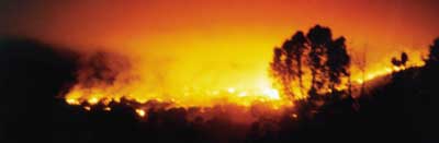 |
More than 5. 9 million acres in the western United States were burned by wildfires as of September 2000. At one point during the summer of 2000, 84 fires, involving more than one million acres, were active in Arizona, California, Idaho, Montana, Nevada, Oklahoma, Texas, Utah, and Wyoming, according to the National Interagency Fire Center (NIFC) in Boise, Idaho. In response to these devastating wildfires, federal firefighting agencies and private industry created the Geospatial Multi-Agency Coordination (GeoMAC) group. |
This project developed an Internet application based on ArcIMS and ArcSDE that provides decision support for prioritizing the use of wildfire suppression resources and critical information for public and firefighter safety. The GeoMAC team was assembled quickly. Business and functional requirements were developed on the fly concurrently with the actual application development efforts. In a period of less than two weeks, the GeoMAC project progressed from conception to full implementation.
| |
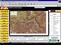
GeoMAC provides decision makers and fire managers with an overview of the current fire situation.
|
|
|
The GeoMAC project is hosted by the United States Geological Survey (USGS) Rocky Mountain Mapping Center in Lakewood, Colorado. Government personnel from the Bureau of Indian Affairs (BIA), Bureau of Land Management (BLM), National Park Service (NPS), U.S. Forest Service (USFS), USGS, National Oceanic and Atmospheric Administration (NOAA), and the NIFC, as well as private partners that include Esri, IBM, and Sun Microsystems, have worked on GeoMAC.
A New Paradigm
GeoMAC represents a new paradigm in the world of wildland fire suppression. It uses information technology to augment traditional firefighting methods. The application provides fire managers and other decision makers with an overview of the current fire situation. This overview includes the location and representative spread of all active fires, the proximity of fires to populated places, and basemap and terrain information. Macroscale resource decisions can be made based on this information.
"The initial goal of the GeoMAC project was to implement a strategic level Internet-based mapping application to aid in the allocation of firefighting resources to the most critical fire incidents in the Great Basin region of western Montana, Idaho, Oregon and Utah," said Robert Plantrich, incident commander for the GeoMAC incident team. "These maps will enable fire personnel to obtain a quick snapshot of near real-time fire hazards."
The GeoMAC project rapidly evolved and a variety of different data sources were identified, prioritized, and processed into suitable formats and made available over the Internet. The data available over the Web included course resolution fire location data from several sources including NIFC's Incident Management Situation Report (Sit Rep), thermal patterns representing potential fire hot spots from processed Advanced Very High Resolution Radiometer (AVHRR) data, and additional potential fire locations identified from visible light data extracted from Defense Meteorological Satellite Program (DMSP) sources.
Adding to the Scope of GeoMAC
As the value of the GeoMAC Web application was realized, the project rapidly expanded from the initial strategic level incident mapping application to include other levels of functionality. Almost immediately, the value of disseminating the information to the general public became apparent. The geographic area covered by GeoMAC was expanded as fire communities in other western states recognized the value of providing data via the Web.
| |
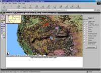
Almost immediately, the value of disseminating this information to the general public became apparent.
|
|
|
Other Web-based mapping applications were subsequently developed. One of these applications gives fire managers more highly detailed data at the incident level. Links to fire weather stations, 1:100,000-scale digital line graph (DLG) roads and hydrography data, hydrologic units, aviation hazards, and digital raster graphics (DRG) 7.5-minute USGS quad data are included in this application.
Another application supports tactical aircraft use. The Temporary Flight Restrictions (TFRs) application uses the Internet to disseminate and update TFRs from the fire incident command center. It is a significant improvement over current operating procedures. The TFR application uses NOAA flight navigation sectional maps to provide background images.
As the initial wildland fire situation eased, the GeoMAC team shifted the focus to supporting Burned Area Emergency Rehabilitation (BAER) teams by providing spatial data online. With this data BAER team members could see old fire perimeter data and the 1:24,000, 1:100,000, and 1:250,000-scale quad indexes at the same time and evaluate which quads were needed to perform standard BAER analysis. BAER team members could use the Web application to directly order the appropriate data via the Internet.
Building GeoMAC
ArcIMS 3 and ArcSDE 8.0.2 for Oracle 8i formed the basis for the GeoMAC project applications. ArcSDE served the data to ArcIMS. ArcIMS served the maps on the Internet. The project used two Sun quad processor 300 MHz UltraSPARC-II Enterprise 450 servers for ArcIMS, Oracle, and ArcSDE, and an IBM Netfinity 5500 quad processor Pentium III Xeon NT server used for additional ArcIMS and the public access pages. A third Sun dual processor 300 MHz Enterprise 450 housed the Netscape Enterprise 3.6 Web server software.
This multiple platform/server configuration was necessary to accommodate Web services accessed internally by the fire community and externally by the public. The allocation of system resources had to be balanced between several categories of users. The internal GeoMAC application and the external public pages were each served data from ArcSDE on separate Sun servers. Security and Internet access also mandated the use of multiple servers. Duplicate Oracle 8i databases and ArcSDE instances were created to serve vector data to the Web applications. Data processed in ArcInfo 8.0.2 that was made available to ArcIMS and loaded into ArcSDE.
Customizing ArcIMS-HTML Viewer, a book that is part of the standard ArcIMS documentation, was used as the guide for modifications made to the HTML Viewer that comes with ArcIMS. Standard HTML and JavaScript editing tools were used to achieve the look and feel of the GeoMAC site. The application had to be functional yet easy to use. These customizations made these maps accessible to people with varying degrees of GIS experience.
Database Preparation and Implementation
In addition to balancing the needs of different users, the application had to integrate information from many agencies. Accessing point data from the NIFC Sit Reps required the creation of an Oracle database link between the primary GeoMAC database instance and the NIFC Oracle database located at the U.S. Department of Agriculture Kansas City Computer Center. Oracle database views were created using the database link to select the fields from the NIFC Sit Rep database needed for the GeoMAC application.
The Oracle views also facilitated the conversion of fire location data stored in latitude/longitude as degrees, minutes, and seconds (DMS) to decimal degrees (DD). Oracle date fields were converted into character format in the Oracle views to support better interaction with ArcIMS functionality. Subqueries were also applied in the views to separate active and inactive fires into two separate ArcSDE layers.
ArcInfo AML scripts were developed to process the Oracle views into ArcSDE point layers. The AML scripts were added as system processes that would be executed automatically every 12 hours to reflect periodic updates to the Sit Rep data. AML processes also automated the output of several HTML components of the GeoMAC Web application. A drop-down box at the upper lefthand side of the interface contains a pull down list of active fire that can be zoomed to directly. The names for these fires are generated by the AML and use geographic locations extracted from the Oracle views. Status pages, displaying the currency of the data and data processing dates are also output using AML scripts and added automatically to the GeoMAC Web pages.
Course-scale fire location polygons were extracted from both AVHRR data and DMSP satellite data. The AVHRR derived polygons were appended to the appropriate ArcSDE layer after each satellite pass over the GeoMAC area of coverage. Attribute items were recalculated and displayed based on rotating 12- and 24-hour periods. The most current data is displayed in red with older fire polygons displayed in more subdued colors. This presented fire managers with a generalized look at the relative spread of fires. Fine-scale fire perimeter data was also uploaded from field offices and processed manually into a single ArcSDE layer. A significant amount of manual processing is required to aggregate fire perimeter data into a single layer, but this data gives fire managers an accurate representation of the actual fire locations.
Next Evolution
The need to quickly implement GeoMAC meant that not all of the functionality of ArcIMS was utilized in the development process. The application will benefit from the ArcIMS-based Geography Network and additional functionality in ArcIMS. The initial GeoMAC application made use only of the Image Server. The Image Server reads data that can come from shapefiles, ArcSDE layers, or a variety of image formats, and creates a complete map image that is sent to the Web browser client.
Future applications will be able to make use of ArcIMS Feature Server. This server streams vector data down to the client Web browser. A Java applet on the client's side renders the map locally. Using the vector streaming lets the client application see the data as though it were available from local drive or an ArcSDE instance. ArcInfo 8.1, Arc Editor 8.1, and ArcView 8.1--soon to be released components of ArcGIS--can all be clients for an ArcIMS server. This will dramatically increase the ability for field units to have direct access to a wide range of remote data that will dramatically increase their ability to perform advanced analysis.
The increase in available data provided by ArcIMS Feature Services and the Geography Network will significantly decrease the need for local storage. Federal, state, and local organizations that use or provide real-time wildfire information will have the ability to share that data much more efficiently. ArcIMS also supports feature extraction to the client system allowing direct save functionality to the local host. This benefits sites having minimal bandwidth. These sites can extract data during nonpeak hours to a local storage device. For more information, visit the GeoMAC site at wildfire.usgs.gov.
The author thanks Jeff Baranyi of Esri-Boulder and John Guthrie of the USGS Rocky Mountain Mapping Center for their assistance with this article.
|