|
Information on Rivers Flows Using GIS
By Monica Pratt, ArcUser Editor
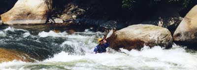
Depending on the river chosen, paddle sports such as kayaking, canoeing, or rafting can be either the most exciting and adventuresome of activities or a relaxing way to explore and appreciate scenery and wildlife. Regardless of the attraction--thrills or tranquility--the number of people who enjoy these water sports in the United States is increasing. The recent growth in membership in the American Canoe Association (ACA), an organization that has been promoting these activities since 1880, illustrates this point. The ACA has grown from 5,000 members in 1993 to more than 45,000 in 2000.
| |
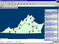
Riverbrowser.com answers the question "Where should we go this weekend?" for whitewater enthusiasts.
|
|
|
The key to enjoying paddle sports is knowing where to go for good water. River conditions are in constant flux so up-to-date information is vital. Neither superior equipment nor advanced paddling skills can overcome the lack of suitable river conditions. Whitewater enthusiasts at TerraLogic, Inc., decided to use GIS to answer the question, "Where should we go this weekend?" According to Daniel Shaffer, president of TerraLogic, "We had guide books and Web pages and by the time you figured out where you were going it was too late in the day to do much. We saw the need to bring this information together."
Located in the Shenandoah Valley in Virginia, TerraLogic is a privately held applications service provider for GIS and AM/FM. The company's experience developing online GIS-based Internet applications that did things such as compare schools based on standardize test scores or track the occurrence of diseases led to the decision to develop this solution as a Web application. Though the application was originally devised simply to give people at the company a better way to plan trips, it has found a much larger audience.
| |
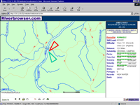
After a river and run are selected, the application displays a map of the area with current river conditions.
|
|
|
The result was Riverbrowser.com, a GIS-enabled Web site that helps whitewater enthusiasts learn about current and forecasted conditions for rivers throughout Virginia. The application TerraLogic developed demonstrates the power of GIS data integration married with the Internet. All the information for planning a trip is available from a single map interface.
The interactive application uses ArcIMS from Esri with Allaire's ColdFusion. It provides access not only to TerraLogic's whitewater database but links users to data from the Environmental Protection Agency (EPA), the United States Geological Survey (USGS), and the National Oceanic and Atmospheric Administration (NOAA) as well as collecting and displaying information supplied by visitors. Though current information on river levels, weather, and other conditions that affect paddling sports has been available from federal agencies via the Internet for some time, finding out conditions for a specific area can be challenging owing to the sheer volume of data available. Riverbrowser.com uses links directly to pertinent information on a particular basin, river, or run by using geography.
For instance, after choosing the Bent Creek to Wingina run of the James River, clicking on "Forecasts" yields links to the portion of the NOAA Web site containing weather and river forecasts for Appomattox, Nelson, and Buckingham counties, the three counties crossed by this section of the James River. Clicking on "Maps" from the same interface links to the Gladstone, Shipman, and Howardsville USGS quadrangle maps that show the area surrounding this portion of the river. These downloadable scanned copies of quadrangle maps, in Tagged Image Format (TIF), are accompanied by world files for georeferencing the TIF images. These maps can be opened in ArcExplorer or ArcView GIS. Choosing the name of the basin containing the river brings up a section of the EPA Web site that supplies a detailed environmental profile of drainage basin.
Visitors can look up any major river in Virginia or can ask for a list of all rivers that are runable (i.e., currently suitable for whitewater sports). The runs for each river are categorized based on USGS stream flow data. Additional information for each run includes skill level ratings, difficulty classifications for the run generally and for its most challenging section, other suitable uses such as camping or cruising, width, length of the run, number of portages, and any hazards. The site also rates runs for ease of put-in and take-out, scenery, velocity of the river, and ease of rescue.
Though originally built using MapObjects 2, Riverbrowser.com was recreated as an ArcIMS and ColdFusion application shortly after the release of ArcIMS. Said Shaffers, "ArcIMS was the easiest product for us to use. To us it's the best product out there." As TerraLogic already possessed a great deal of expertise with ColdFusion, it was natural for developers to use the ColdFusion Connector to access the ArcIMS Application Server.
| |
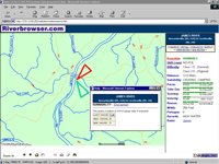
Riverbrowser.com harvests up-to-date stream flow data from the USGS site.
|
|
|
TerraLogic offers Riverbrowser.com as a free service to the public. The response to the site has been overwhelmingly positive. "With this application, I think we hit the nail on the head for whitewater people. I have received e-mails from people in every state asking for the same service," said Shaffers. The public reaction has led TerraLogic to consider expanding Riversbrowser.com nationwide but this will require base mapping and detailed river information on a much larger scale. The company has approached both ACA and the American Whitewater Affiliation to access the river information these organizations have cataloged.
For more information on Riverbrowser, please contact
Daniel Shaffer, President
TerraLogic, Inc.
116 North Central Avenue
Staunton, Virginia 24401
E-mail: shaffer@terra-logic.net
Tel.: 540-2123-2447
Web: www.terra-logic.net
|