|
New Methods for Delivering
Government Services
by Jay Thatcher and Natalie Lane Hoel, Akanda Innovation
Local governments are often squeezed between high public expectations and limited internal resources. The size of operating budgets can limit staffing and increase workloads. Without continued funding, technologies become outdated. This can lead to partially completed projects or solutions for individual departments that address short-term needs in a Band-Aid fashion. Many government operations utilize manual methods or still separate GIS data from business processes and work flow, resulting in significant inefficiencies. Governments vary in the level of collaboration that occurs between departments. Manual interfaces provide limited methods to exchange data.
Taxpayers and private and public sector organizations demand improved access to government and service. Today's government needs to respond to the cry for a "one-stop, self-help" model of enabling government services and integrating information and processes traditionally held by the GIS, tax, building, zoning, and licensing departments. This model addresses the current challenges of government and provides flexible and interactive mediums to deliver services.
A Tale of Two Innovative Cities
The cities of Sarasota, Florida, and Houston, Texas, are developing enterprise solutions using the Collaborative Community Teaming Environment (COLATE) suite from Akanda Innovation that includes embedded Esri technology. These solutions are helping both cities empower staff and citizens to reinvent government services. Akanda Innovation is an Esri business partner and longtime developer with expertise in MapObjects, ArcSDE, Domino, and Oracle. The company has successfully integrated mapping components within collaborative work flow applications to provide map visualization and reporting for users who are not GIS experts.
Sarasota—Integrating Data
Sarasota is a city of 65,000 that is perhaps best known as a winter vacation haven. While residents and visitors to the City were enjoying its beaches and sun, the City's internal operations were not as tranquil. Operationally, the City used COBOL applications for departmental functions such as building permitting and business licensing. Reliance on the data in these applications, compounded by the lack of interoperability with other systems, lack of year 2000 compliance, and support problems, made a strong technical argument for system replacement. In addition, City Information Systems staff wanted a more integrated and sophisticated enterprise system that used GIS and improved work flow and messaging to better manage City responsibilities such as code enforcement and development review tracking. The City envisioned a system in which all departmental applications had the same look and feel and could centrally access data. GIS would be embedded into each application, offering a unified visual interface for the data.
The overall justifications given for replacing COBOL applications with an integrated approach were
- The ability to provide information for integrated decision making
- Faster delivery and higher quality of services
- Provides 24/7 access to services and the ability to handle a higher volume of work
- Reduced cost and lower overhead
Houston—Fighting the Paper Trail
Houston is a much larger city than Sarasota, and it is growing rapidly. With a population of nearly two million, Houston is the fourth-largest city in the United States, and the Houston area is third in growth among the 10 largest metropolitan areas. Houston's growth rate has placed a considerable demand on its internal resources, especially development tracking.
Prior to Houston's move to use the Internet and GIS to provide services, development tracking was isolated from GIS. Tracking of land development was a largely manual process, made worse by a requirement that a decision be made on each development application within nine days of submission. Submitted plats were added to the City's paper map files and were not entered into the GIS database for months. The City's rapid growth caused its GIS database to become out of sync with a "sister" database maintained by Harris County. This mixture of booming land development and inefficient methods provided a strong motivation for change.
Common Themes
Both Sarasota and Houston had outdated technologies that were impeding day-to-day departmental operations and preventing the sharing of information with other departments. Existing applications served a single departmental function with no reference to or operability with enterprise systems. Proponents of GIS adoption wanted the flow of information for applications to parallel the actual work flow and wanted to use a "one-stop, self-help" model for customer service that could be leveraged across developments in a collaborative fashion using Internet technologies. This type of solution could accommodate future growth and demands. Both cities were already users of Esri technology, and both wanted to spatially enable their databases and processes.
Making the Switch to E-gov
| |
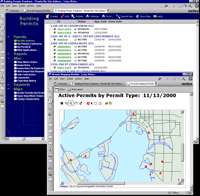
The City of Sarasota developed six applications including the permit and inspection application shown here.
|
|
|
Though Sarasota and Houston faced common problems and had similar goals, the process each used to implement change varied as a result of legacy systems and the new technologies available to each city at the time changes were made. Sarasota had already installed Lotus Note/IBM Domino as its messaging and work flow platform when the project to replace the COBOL departmental applications began. This proved to be very timely because that system laid the foundation for the implementation of Akanda's modules. GIS and departmental process functionality could be added to a Lotus Notes/Domino application. Sarasota had also identified Internet capability as a required longer term goal for the application suite. This requirement could easily be satisfied using the Lotus/IBM architecture. MapObjects would be used to add a spatial dimension to the applications and leverage the City's mapping investment.
Over a span of two years, beginning in 1997, six applications were defined by the City and designed, implemented, and supported by Akanda. These applications handled
- Permits and inspections management
- Code enforcement and complaint management
- Contractor registration management
- Business license management
- Property situs address management
- Fee tracking
Houston was a more recent adopter of Online Collaborative Communities. Project planning began in 1999.
| |
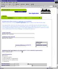
Houston requires that all land development applications be submitted online.
|
|
|
However, in the two years between the project starts for Sarasota and Houston, significant changes occurred in the role of the Internet as a vehicle for delivering services and interacting with the public. Consequently, Houston chose Akanda's Development Review Committee (DRC) tracking solution. Houston was so committed to its E-gov strategy that the City decided to only accept land development applications electronically. Applicants lacking private Internet access would submit applications through City kiosks.
Houston's DRC solution was also built using Lotus/IBM/Esri architecture. This architecture provides an Internet-enabled end-to-end system for accepting online development applications, managing and tracking the application process, and accepting input from outside commenting agencies such as utility companies. The Houston implementation provides a robust solution with the following functionality:
- Land developers can submit development applications online that include the forms and CAD plat drawings.
- City Planning Department staff has a tool that manages the entire development review process, uses rules or the type of case to assign staff or approvals, and generates agendas and content for committee meetings automatically.
- Plats can be marked up online by commenting agencies. Utility companies can assign street numbers, and other commenting agencies can identify changes using a Web browser.
- CAD plat drawings can be entered in the City's ArcInfo database and will be available in the preliminary and final stages.
Houston also chose Akanda's GIS TeamRoom solution to help with GIS database maintenance. As changes are made to the Harris County database, they are automatically noted in a GIS TeamRoom database at the City so that GIS supervisors can evaluate the changes, assign a technician, and track the entire life cycle of a modification request.
Continuing the Move Forward
Sarasota has been using its new solutions since 1998 with ongoing product and technical support from Akanda. Houston's DRC and GIS TeamRoom implementations have been in full swing since the fall of 2000. These two innovative cities are already planning the next steps in making local government work even smarter. Both cities are considering Web enabling other processes including the submission of permit applications, inspection requests, complaints, and license renewals. They are poised on the cutting edge of a technology that will redefine government in ways that allow for greater public access and participation.
Sarasota and Houston have harnessed the benefits of a collaborative approach to local government management. Each city replaced old, inefficient processes with Internet-based approaches to doing business. These solutions create a seamless environment that transcends departmental approaches and provides true enterprise data access. Moving government online is part of a larger movement designed to make all government more efficient and responsive to the increasing demands of the public. For more information about the projects at Sarasota or Houston, please contact
Jay Thatcher, Project Manager
Tel.: 887- 487-5005, ext. 2227
E-mail: jthatcher@akanda.com
or
Natalie Lane Hoel, Program Manager
Tel.: 887- 487-5005, ext. 2226
E-mail: nhoel@akanda.com
About the Authors
Jay Thatcher
Jay Thatcher is a project manager with Akanda Innovation. He is involved with online government solutions and GIS services. He has a master's degree in planning from the University of Guelph, a certificate in GIS from the College of Geographic Sciences, and a bachelor's degree in geography from Lakehead University. Before joining Akanda Innovation, he was a GIS developer and consultant for a Canadian engineering firm and a support analyst with Esri Technical Support.
Natalie Lane Hoel
Natalie Hoel is the Program Manager at Akanda Innovation. She helps develop and implement comprehensive solutions for E-government. She holds a master's degree in geography from Murray State University and a bachelor's degree in geology from the State University of New York College at Fredonia. Prior to joining Akanda Innovation, she was a technical support team leader at Esri.
Acknowledgments
The authors commend the staff members at the cities of Sarasota and Houston for their enthusiasm and commitment. Due to the dedication of the implementation team at the City of Houston, a successful transition to the new environment was accomplished in less than a year.
|